
The United States Census Bureau (USCB), officially the Bureau of the Census, is a principal agency of the U.S. Federal Statistical System, responsible for producing data about the American people and economy. The Census Bureau is part of the U.S. Department of Commerce and its director is appointed by the President of the United States. Currently, Rob Santos is the Director of the U.S. Census Bureau and Dr. Ron Jarmin is the Deputy Director of the U.S. Census Bureau

The United States had an official estimated resident population of 334,914,895 on July 1, 2023, according to the U.S. Census Bureau. This figure includes the 50 states and the District of Columbia but excludes the population of five unincorporated U.S. territories as well as several minor island possessions. The United States is the third most populous country in the world, and the most populous in the Americas and the Western Hemisphere. The Census Bureau showed a population increase of 0.4% for the twelve-month period ending in July 2022, below the world average annual rate of 0.9%. The total fertility rate in the United States estimated for 2022 is 1.665 children per woman, which is below the replacement fertility rate of approximately 2.1.

Manassas Park is an independent city in the U.S. state of Virginia. As of the 2020 census, the population was 17,219. Manassas Park is bordered by the city of Manassas and Prince William County. Manassas Park is a part of the Washington-Arlington-Alexandria, DC-VA-MD-WV Metropolitan Statistical Area.

The City of Northglenn is a home rule municipality located in Adams and Weld counties, Colorado, United States. Northglenn is a part of the Denver–Aurora–Lakewood, CO Metropolitan Statistical Area. As of the 2020 census the city's population was 38,131. It was built as a master planned community in 1959 by Jordon Perlmutter.

Pearson is a city in Atkinson County, Georgia, United States. The population was 1,821 in 2020. The city is the county seat of Atkinson County.

Alma is a city in Bacon County, Georgia, United States, and the county seat. As of the 2020 census, the city had a population of 3,433.
Nahunta is a city and the county seat in Brantley County, Georgia, United States. It is part of the Brunswick, Georgia metropolitan statistical area. The population was 1,013 at the 2020 census. The city is an important crossroad which is intersected by U.S. Route 82 and U.S. Route 301 in its downtown area.

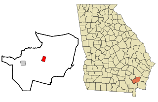
Morgan is a city in Calhoun County, Georgia, United States. The population was 1,741 at the 2020 census. The city is the county seat of Calhoun County.
Evans is an unincorporated community and census-designated place (CDP) in Columbia County, Georgia, United States. It is a suburb of Augusta and is part of the Augusta metropolitan area. The population was 29,011 at the 2010 census, up from 17,727 at the 2000 census.

Hamilton is a city in, and the county seat of Harris County, Georgia, United States. It is part of the Columbus, Georgia-Alabama metropolitan statistical area. The population was 1,680 at the 2020 census, up from 307 at the 2000 census.

Hazlehurst is a city in and the county seat of Jeff Davis County, Georgia, United States. The population was 4,088 in 2020.

Gray is a city in Jones County, Georgia, United States. The population was 3,276 at the 2010 census, up from 1,811 at the 2000 census. In 2020, its population was 3,436. The city is the county seat of Jones County. It is part of the Macon metropolitan area.

Oglethorpe is a city in Macon County, Georgia, United States. The population was 995 at the 2020 census, down from 1,328 in 2010. The city is the county seat of Macon County. It was named for Georgia's founder, James Oglethorpe.

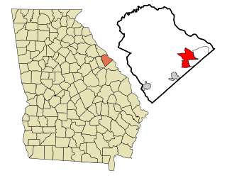
Chatsworth is a city in and the county seat of Murray County, Georgia, United States. It is part of the Dalton, Georgia, Metropolitan Statistical Area. Its population was 4,874 at the 2020 census, up from 4,299 in 2010. The city is the site of the coldest recorded temperature in Georgia, −17 °F (−27 °C) on January 27, 1940.

Paint Rock is a town in and the county seat of Concho County, Texas, United States. The population was 237 at the 2020 census.

Daingerfield is a city and the county seat of Morris County, Texas, United States. The population was 2,560 at the 2010 census.

Handley is a town in Kanawha County, West Virginia, United States. The population was 224 at the 2020 census. Handley was first established in 1877 and known as Upper Creek until July 29, 1881, when its name was changed to Handley for pioneer settlers who farmed the area. Handley has the distinction of bearing a name like no other town in the United States. The town was incorporated November 1972.
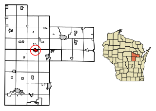
Marion is a city in Shawano and Waupaca counties in the U.S. state of Wisconsin. The population was 1,324 at the 2020 census.

Ascutney is an unincorporated village and census-designated place (CDP) in the town of Weathersfield, Windsor County, Vermont, United States. It is located in the northeastern section of Weathersfield, in the portion of that town adjacent to Mount Ascutney, after which the village is named. As of the 2010 census, the population of the CDP was 540.


