Prairie City, South Dakota

Last updated

Prairie City
USA South Dakota location map.svg
Red pog.svg
Prairie City
Location within the state of South Dakota
Usa edcp location map.svg
Red pog.svg
Prairie City
Prairie City (the United States)
Coordinates: 45°31′52″N102°48′59″W / 45.53111°N 102.81639°W / 45.53111; -102.81639
Country United States
State South Dakota
County Perkins
Township Strool
Area
[1]
  Total1.42 sq mi (3.68 km2)
  Land1.41 sq mi (3.65 km2)
  Water0.05 sq mi (0.13 km2)
Elevation
[2]
2,861 ft (872 m)
Population
 (2020)
  Total25
  Density18/sq mi (6.8/km2)
Time zone UTC-6 (Central (CST))
  Summer (DST) UTC-5 (CDT)
ZIP codes
57649
Area code 605
GNIS feature ID2584566 [2]

Prairie City is an unincorporated community and census-designated place in Perkins County, South Dakota, United States. One of many rural settlements in Perkins County, the town was founded in 1946 by former residents of Strool. [3] The population of the CDP was 25 at the 2020 census. [4]

Contents

History

Prairie City was founded in 1946 by Dutch Stalder, [3] and built up by former residents of Strool. The town of Strool was entirely owned by its founder, homesteader Ben Strool, who rented out land to residents and businesses, but did not sell any of it. [5] Since this meant Strool's residents and business-owners did not own their property, they were reluctant to construct buildings with permanent features like basements, for fear they could lose the buildings they had invested in. [6] Moreover, both a railroad and a highway—which had initially been slated to pass through Strool—were later built several miles away, bypassing the area and making it inconvenient to reach. [5] [6]

By 1946, some residents of Strool had decided to relocate two miles north and form the settlement of Prairie City. [7] Comparatively, Prairie City would be closer to the highway [7] and allow settlers to purchase land. [6] The move to Prairie City was hastened by multiple factors, including the arrival of electrical infrastructure in 1952 (as settlers did not want to install electricity in rented property), Ben Strool's death in 1949, and a subsequent feud over the ownership of the settlement. [6] The relocation was largely complete by 1955, and with so many settlers moving to Prairie City in such a short span of time, Prairie City briefly earned the title of "the fastest-growing town" in South Dakota. [3] [8]

Prairie City's post office was established in 1955. [9] It was first recorded as a census-designated place in the 2010 census. [10]

In 2009, Prairie City's post office was shut down, though the CDP kept its 57649 ZIP code. Its postal services are now handled by the town of Bison. [11] [12]

Demographics

Historical population
CensusPop.Note
2010 23 [13]
2020 25 [4] 8.7%
U.S. Decennial Census [14]

2020 census

Prairie City racial composition [4]
RaceNum.Perc.
White 2080.0%
Black or African American 00.0%
Native American 28.0%
Asian 14.0%
Pacific Islander 00.0%
Other/Mixed 28.0%
Hispanic or Latino 28.0%

At the 2020 United States census, there were 25 people living in Prairie City. The population density was 17.7 people per square mile (6.8/km2), with 18 housing units at an average density of 12.8 per square mile (4.9/km2).

2010 census

At the 2010 United States census, there were 23 people, 9 households, and 4 families living in Prairie City. The population density was 16.2 people per square mile (6.3/km2), with 14 housing units at an average density of 9.9 per square mile (3.8/km2). The racial makeup was 100% white.

There were 9 households, of which 1 (2.3%) had children under the age of 18 living with them, 3 (33.3%) were married couples living together, 1 (2.3%) had a female householder with no husband present, and 5 (55.5%) were non-families. All 5 households were made up of individuals, and 2 (22.2%) had someone living alone who was 65 years of age or older. The average household size was 2.56, and the average family size was 4.50.

The population was spread out, with 9 people (39.1%) under the age of 18, 1 person (4.3%) aged 18 to 24, 2 people (8.7%) aged 25 to 44, 9 people (39.1%) aged 45 to 64, and 2 people (8.7%) who were 65 years of age or older. The median age was 43.5 years. For every 100 females, there were 76.9 males.

Notable people

Related Research Articles

<span class="mw-page-title-main">Wheatland, North Dakota</span> Census-designated place in North Dakota, United States

Wheatland is a census-designated place (CDP) in Cass County, North Dakota, United States. The population was 68 at the 2010 census.

<span class="mw-page-title-main">Hecla, South Dakota</span> City in South Dakota, United States

Hecla is a city in Brown County, South Dakota, United States, located only a few miles south of the North Dakota border. The population was 193 at the 2020 census. State Highway 37 runs along the east side of town.

<span class="mw-page-title-main">Verdon, South Dakota</span> Town in South Dakota, United States

Verdon is a town in southeastern Brown County, South Dakota, United States. The population was 3 at the 2020 census.

<span class="mw-page-title-main">Fort Thompson, South Dakota</span> CDP in South Dakota, United States

Fort Thompson is a census-designated place (CDP) in Buffalo County, South Dakota, United States. The population was 1,282 at the 2010 census, making it the largest settlement on the Crow Creek Reservation.

<span class="mw-page-title-main">Henry, South Dakota</span> Town in South Dakota, United States

Henry is a town in southwestern Codington County, South Dakota, United States. The population was 256 at the 2020 census. It is part of the Watertown, South Dakota Micropolitan Statistical Area.

<span class="mw-page-title-main">Fairburn, South Dakota</span> Town in South Dakota, United States

Fairburn is a town in Custer County, South Dakota, United States. The population was 60 at the 2020 census.

<span class="mw-page-title-main">Hermosa, South Dakota</span> Town in South Dakota, United States

Hermosa is a town near the northern edge of Custer County, South Dakota, United States. The population was 382 at the 2020 census.

<span class="mw-page-title-main">Andover, South Dakota</span> Town in South Dakota, United States

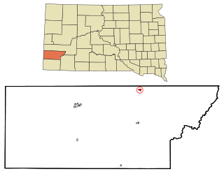
Andover is a town in northwestern Day County, South Dakota, United States. The population was 66 at the 2020 census.

<span class="mw-page-title-main">Clear Lake, South Dakota</span> City in South Dakota, United States

Clear Lake is a city in and the county seat of Deuel County, South Dakota, United States. The population was 1,218 at the 2020 census.

<span class="mw-page-title-main">Gary, South Dakota</span> City in South Dakota, United States

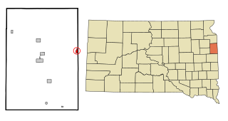
Gary is a city in Deuel County, South Dakota, United States. The population was 240 at the 2020 census. South Dakota Highway 101 serves as the main route of the community. In 2022, the town celebrated its 150th anniversary.

<span class="mw-page-title-main">Timber Lake, South Dakota</span> City in South Dakota, United States

Timber Lake is a city in and the county seat of Dewey County, South Dakota, United States. The population was 509 at the 2020 census.

<span class="mw-page-title-main">Miller, South Dakota</span> City in South Dakota, United States

Miller is a city in and county seat of Hand County, South Dakota, United States. The population was 1,349 at the 2020 census.

<span class="mw-page-title-main">Roswell, South Dakota</span> Census-designated place in South Dakota, United States

Roswell is a CDP in Miner County, South Dakota, United States. The population was 8 at the 2020 census. It disincorporated as a town in 2012.

<span class="mw-page-title-main">Rapid Valley, South Dakota</span> CDP in South Dakota, United States

Rapid Valley is a census-designated place (CDP) and unincorporated community in Pennington County, South Dakota, United States, and a suburb of Rapid City. The population was 8,098 at the 2020 census. Rapid Valley has been a retreat for people living in Rapid City due to its low crime, cheap land, and views of the Black Hills. Rapid Valley is home to many industrial and financial businesses, and is the headquarters for many corporations specializing in transport and engineering.

<span class="mw-page-title-main">Ashton, South Dakota</span> City in South Dakota, United States

Ashton is a city in eastern Spink County, South Dakota, United States. The population was 108 at the 2020 census.

<span class="mw-page-title-main">Doland, South Dakota</span> City in South Dakota, United States

Doland is a city in eastern Spink County, South Dakota, United States. The population was 199 at the 2020 census.

<span class="mw-page-title-main">Iroquois, South Dakota</span> City in South Dakota, United States

Iroquois is a city on the border of Beadle and Kingsbury counties in South Dakota, United States. The population was 292 at the 2020 census. The school building is located in Kingsbury County, while the school parking lot is located in Beadle County. Highway 14 runs directly through Iroquois.

<span class="mw-page-title-main">Overly, North Dakota</span> City in North Dakota, United States

Overly is a city in Bottineau County in the U.S. state of North Dakota. The population was 10 at the 2020 census.

<span class="mw-page-title-main">Auburn, North Dakota</span> Census-designated place & unincorporated community in North Dakota, United States

Auburn is a census-designated place and unincorporated community in Walsh County, North Dakota, United States. Its population was 48 as of the 2010 census.

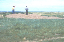
Strool is a ghost town in Perkins County, in the U.S. state of South Dakota. Founded by homesteader Benjamin Strool in 1908, Strool was noted for its thriving culture and baseball team, Jewish community, and practice of renting land rather than selling it.

References

  1. "2020 U.S. Gazetteer Files". United States Census Bureau. Retrieved March 2, 2022.
  2. 1 2 U.S. Geological Survey Geographic Names Information System: Prairie City, South Dakota
  3. 1 2 3 "Prairie City Fast Growing Town in S.D." The Daily Plainsman. Huron, South Dakota. October 4, 1955. p. 6 via Newspapers.com.
  4. 1 2 3 "U.S. Census Bureau: Prairie City CDP, South Dakota". www.census.gov. United States Census Bureau. Retrieved January 28, 2022.
  5. 1 2 Yuill, Camille (January 19, 1956). "The Backlog". The Deadwood Pioneer-Times. p. 3 via Newspapers.com.
  6. 1 2 3 4 Rathbun, Janet Dunlap (2006). "All Roads Led to Strool: The Rise and Fall of One Man's Town" (PDF). South Dakota History. South Dakota Historical Society. Archived (PDF) from the original on February 12, 2022. Retrieved February 11, 2022.
  7. 1 2 "Town of Strool Will Be Moved". Argus-Leader. January 12, 1946. p. 7 via Newspapers.com.
  8. Vanished South Dakota: Towns of Yesterday. South Dakota Public Broadcasting. August 15, 2019. Event occurs at 25:44–28:09. Retrieved February 11, 2022.
  9. "Postal Bulletin" (PDF). United States Post Office Department. December 1, 1955. Archived (PDF) from the original on March 2, 2022. Retrieved March 2, 2022.
  10. "South Dakota: 2010 | Population and Housing Unit Counts" (PDF). United States Census Bureau. p. III-7. Archived (PDF) from the original on January 21, 2022. Retrieved March 2, 2022.
  11. "USPS Postal Bulletin" (PDF). United States Postal Service. December 30, 2010. Archived (PDF) from the original on March 2, 2022. Retrieved March 2, 2022.
  12. Cook, Andrea J. (February 6, 2010). "Prairie City residents fight to get post office reopened". Rapid City Journal. Rapid City, South Dakota. p. 3 via Newspapers.com.
  13. "South Dakota: 2010 | Summary Population and Housing Characteristics" (PDF). United States Census Bureau. Archived (PDF) from the original on January 20, 2022. Retrieved March 2, 2022.
  14. "Census of Population and Housing". Census.gov. Retrieved March 2, 2022.
  15. "Sam S. Marty | South Dakota Historical Legislators". South Dakota Legislative Research Council. Retrieved March 2, 2022.
  16. "Betty Olson | South Dakota Historical Legislators". South Dakota Legislative Research Council. Retrieved March 2, 2022.