History
The Awash River flows through the south and western parts of this Zone, periodically flooding during the June-to-September rainy season. During 1996, the river flooded parts of Bure Mudaytu and Gewane woredas, but a UNDP team dispatched to survey the area failed to find significant damage. [3] However, in August 1999, a planned release of waters from the Koka Reservoir resulted in flooding by the Awash—although an investigation afterwards showed the flooding was caused by dike failures and silting of the Awash, especially around Melka Were. Approximately 5,000 hectares (19 sq mi) of cropland in the Zone, and 12 rural kebeles in Amibara and 3 rural kebeles in Dulecha woredas were affected. [4] The Awash flooded again 16 August 2006, displacing 15,000 people and damaging 400 hectares (1.5 sq mi) planted in cotton, corn, onions and sesame. [5]
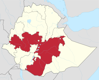
Gewane is one of the woredas in the Afar Region of Ethiopia. Part of the Administrative Zone 3, Gewane is bordered on the south by Amibara, on the west by Bure Mudaytu and Administrative Zone 5, on the north by the Administrative Zone 1, and on the east by the Somali Region; the Awash River defines parts of the boundary with Administrative Zone 5. The administrative centre is Gewane; other towns in Gewane include Meteka.
The Koka Reservoir is a reservoir in south-central Ethiopia. It was created by the construction of the Koka Dam across the Awash River. The reservoir has an area of 180 square kilometers.
A kebele is the smallest administrative unit of Ethiopia, similar to a ward, a neighbourhood or a localized and delimited group of people. It is part of a woreda (district), itself usually part of a Zone, which in turn are grouped into one of the Regions based on ethno-linguistic communities that comprise the Federal Democratic Republic of Ethiopia. Each kebele consists of at least five hundred families, or the equivalent of 3,500 to 4,000 persons. There is at least one in every town with more than 2,000 population. A keftanya, or representative, had jurisdiction over six to twelve kebeles.
In June 2002, the Afar and the Issa Somali, as well as the Afar and the Ittu Oromo, have engaged in armed clashes in Gewane, Amibara and Awash Fentale woredas over grazing resources diminished due to a drought at that time. As a result, the traditional division of work was ignored: women were no longer tending livestock and the men guarded their herds with weapons. Pastoral groups from this Zone concentrated in the Awash lowlands, which forced pastoral groups from Zone 5 to move west and compete with the Argobba. [6]
The Issa are a northern Somali clan, a sub-division of the Dir clan family and is one of the largest clan of the Dir with a large and densely populated traditional territory.
Ittu is one of the divisions of the Oromo people. This group lives dominantly in the present-day Mirab Hararghe Zone. The correct term for the land of Ittus is "Chercher" or "Ona Ituu".
The Argobba are an ethnic group inhabiting Ethiopia. A Muslim community, they are spread out through isolated village networks and towns in the northeastern and eastern parts of the country. Group members have typically been astute traders and merchants, and have adjusted to the economic trends in their area. These factors have led to a decline in usage of the Argobba language.
Demographics
Based on the 2007 Census conducted by the Central Statistical Agency of Ethiopia (CSA), this Zone has a total population of 198,751, of whom 108,995 are men and 89,756 women. While 54,328 or 27.33% are urban inhabitants, a further 24,075 or 12.11% were pastoralists. Seven largest ethnic groups reported in Zone 3 were the Afar (64.78%), Amhara (12.01%), Argobba (10.72%), Wolayta (4.05%), Oromo (2.75%), Hadiya (1.25%), Kambaata (1.19%); all other ethnic groups made up 3.25% of the population. Afar is spoken as a first language by 64.66%, Amharic by 22.25%, Argobba by 5.42%, Wolaytta (2.89%), Oromo (1.51%); the remaining 3.27% spoke all other primary languages reported. 81.3% of the population said they were Muslim, 13.8% were Orthodox Christians, and 4.45% were Protestants. [7]

The Afar, also known as the Danakil, Adali and Odali, are an ethnic Cushitic peoples inhabiting the Horn of Africa. They primarily live in the Afar Region of Ethiopia and in northern Djibouti, although some also inhabit the southern point of Eritrea. Afars speak the Afar language, which is part of the Cushitic branch of the Afroasiatic family.
Amharas also known as Abyssinians, are an ethnic group traditionally inhabiting the northern and central highlands of Ethiopia, particularly in Addis Ababa and the Amhara Region.. According to the 2007 national census, Amharas numbered 19,867,817 individuals, comprising 26.9% of Ethiopia's population. They are also found within the Ethiopian expatriate community, particularly in North America. They speak Amharic, an Afro-Asiatic language of the Semitic branch, a member of the Ethiosemitic group, which serves as the official language of Ethiopia.
The Welayta, Wolayta or Wolaitta are an ethnic group and its former kingdom, located in southern Ethiopia. According to the most recent census (2007), the people of Wolayta number 1.7 million, or 2.31 percent of the country's population, of whom 289,707 are city-dwellers. The language of the Wolayta people, similarly called Wolaytta, belongs to the Omotic branch of the Afro-Asiatic language family. Despite their small population, Wolayta people have widely influenced national music, dance and cuisine in Ethiopia.
The 1996, the national census reported a total population for this Zone of 150,346, of whom 82,657 were men and 67,689 women; 36,929 or 24.56% of its population were urban dwellers at the time. The major ethnic groupings in 1996 were 70.8% Afar, 10.43% Amhara, 6.43% Argobba, 3.82% Oromo, and 3.14% Welayta. Of the school-age school-age children, 7.35% (8.22% male and 6.29% female) were currently attending school, which is higher than the Regional average; 19.84% of the total population over the age of 10 (22.75% male and 16.33% female) are reported to be literate. [8]

The Oromo people are an ethnic group inhabiting Ethiopia. They are one of the largest ethnic groups in Ethiopia and represent 34.5% of Ethiopia's population. Oromos speak the Oromo language as a mother tongue, which is part of the Cushitic branch of the Afro-Asiatic language family. The word Oromo appeared in European literature for the first time in 1893 and then slowly became common in the second half of the 20th century.

Oromia Zone is one of the zones in the Amhara Region of Ethiopia. Oromia is named for the Oromo people, who settled along the edge of the Ethiopian highlands that form this Zone. Oromia Zone is bordered on the southwest by Semien Shewa, on the northwest by Debub (South) Wollo and Argobba special woreda, and on the east by the Afar Region. Kemise is the administrative center of the Zone; other towns include Bati.

Administrative Zone 1 is one of five Zones of the Afar Region of Ethiopia. This zone is bordered on the south by Administrative Zone 3, on the southwest by Administrative Zone 5, on the west by the Amhara Region, on the northwest by Administrative Zone 4, on the north by Administrative Zone 2, on the northeast by Eritrea, and on the east by Djibouti.
Amibara is one of the woredas in the Afar Region of Ethiopia. Part of the Administrative Zone 3, Amibara is bordered on the south by Awash Fentale, on the west by the Awash River which separates it from Dulecha, on the northwest by the Administrative Zone 5, on the north by Gewane, on the east by the Somali Region, and on the southeast by Oromia Region. Towns in Amibara include Awash Arba, Awash Sheleko, Melka Sedi and Melka Were.
Awash Fentale is one of the woredas in the Afar Region of Ethiopia. Part of the Administrative Zone 3, Awash Fentale is bordered on the south by the Oromia Region, on the west by the Amhara Region, on the north by Dulecha, and on the east by Amibara. Towns in Awash Fentale include Awash Sebat Kilo and Sabure.
Dulecha is one of the woredas in the Afar Region of Ethiopia. Part of the Administrative Zone 3, Dulecha is bordered on the south by Awash Fentale, on the west by the Argobba special woreda, on the north by the Administrative Zone 5, and on the east by the Awash River which separates it from Amibara. The largest settlement in Dulecha is Dulecha.
Bure Mudaytu is one of the woredas in the Afar Region of Ethiopia. Part of the Administrative Zone 3, Bure Mudaytu stretches along a narrow band covering the marshy lowlands along the Awash River, with the Administrative Zone 5 to the west and Gewane to the east. The administrative center of this woreda is Debel.
Were Babu is one of the woredas in the Amhara Region of Ethiopia. This woreda is named for one of the "Houses" or subgroups of the Wollo Amhara that used to govern the area and is still located there. Part of the Debub Wollo Zone, Were Babu is bordered on the south by Kalu, on the west by Tehuledere, on the north by the Mille River which separates it from the Semien Wollo Zone, on the east by the Afar Region, and on the southeast by the Mio River which separates it from the Oromia Zone. The administrative center of Were Babu is Bistma; other towns include Arabati and Bokeksa.
Kalu is one of the woredas in the Amhara Region of Ethiopia. Part of the Debub Wollo Zone, Kalu is bordered on the west by Dessie Zuria, on the north by Were Babu, on the south and east by the Oromia Zone, on the southeast by Argobba special woreda, and on the southwest by Abuko. The administrative center for this woreda is Harbu; other towns in Kalu include Ancharo, Gerba and Degan. A highway linking Kombolcha and Afar bisects Kalu to two parts.
Debre Sina now it is called Borena is one of the woredas in the Amhara Region of Ethiopia. Part of the Debub Wollo Zone, Debre Sina is bordered on the south by Wegde, on the west by the Abbay River which separates it from the Misraq Gojjam Zone, on the north by Mehal Sayint, on the northeast by Sayint, and on the east by Legambo. The administrative center is Mekane Selam; other towns in Debre Sina include Amsale Genet.
Kewet is one of the woredas in the Amhara Region of Ethiopia. Part of the Semien Shewa Zone, Kewet is bordered on the southwest by Termaber, on the northwest by Menz Mam Midir, on the north by Efratana Gidim, and on the east by Afar Region. The major town in Kewet is Shewa Robit.
Termaber is one of the woredas in the Amhara Region of Ethiopia. Located at the eastern edge of the Ethiopian highlands in the Semien Shewa Zone, Termaber is bordered on the south by Ankober, on the southwest by Basona Werana, on the west by Mojana Wadera, on the northwest by Menz Mam Midir, on the northeast by Kewet, and on the southeast by the Afar Region. Towns in this woreda include Debre Sina and Doqaqit.
Menjarna Shenkora is one of the woredas in the Amhara Region of Ethiopia. It is named in part after a historic district of Shewa, Menjar, which was the southernmost district of Shewa and near the location of the modern woreda. Located at the southern end of the Semien Shewa Zone, Menjarna Shenkora is bordered on the east, south and west by the Oromia Region, on the northwest by Hagere Mariamna Kesem, and on the northeast by Berehet; the Germama river forms the boundary between this woreda and Hagere Mariamna Kesem and Berehet. The administrative center of this woreda is Arerti; other towns in the woreda include Balchi and Eranbuti.
Chefe Golana Dewerahmedo was one of the 105 woredas in the Amhara Region of Ethiopia. Part of the Oromia Zone, Chefe Golana Dewerahmedo was bordered on the south by Artuma Fursina Jile, on the southwest by the Semien Shewa Zone, on the west by the Debub Wollo Zone, on the north by Bati, and on the east by the Afar Region. Towns in Chefe Golana Dewerahmedo included Bora and Kemise; the villages of Shonke and T’ollaha were also located in this woreda, and notable as being communities where the Argobba language is spoken. Chefe Golana Dewerahmedo was divided for Dawa Chefe and Dawa Harewa woredas and Kemise town.
Bati is one of the woredas in the Amhara Region of Ethiopia. Part of the Oromia Zone, Bati is bordered on the south by Dawa Harewa, on the southeast by the Argobba special woreda, on the west and north by the Debub Wollo Zone, and on the east by the Afar Region. Towns in this woreda include its administrative center, the market town of Bati. The towns of Degan and Gerba was administratively part of Bati prior to the 2007 census but was then transferred to Kalu woreda.
Fentale is one of the woredas in the Oromia Region of Ethiopia. Part of the Misraq Shewa Zone located in the Great Rift Valley, Fentale is bordered on the southeast by the Arsi Zone, on the southwest by Boset, on the northwest by the Amhara Region, and on the northeast by the Afar Region. The administrative center of Fentale is Metehara; other towns include Haroo Adii.
Moyale is one of the woredas in the Oromia Region of Ethiopia. It is named after the administrative center of the woreda, Moyale. Located in the southeast corner of the Borena Zone, Moyale is bordered on the south by Kenya, on the west by Dire, on the northwest by Arero, on the north by the Dawa River which separates it from Liben, and on the east by the Somali Region.
Argobba is one of the woredas in the Amhara Region of Ethiopia. Because Argobba is not part of any Zone in the Amhara Region, it is considered a Special woreda, an administrative subdivision which is similar to an autonomous area. This woreda is named for the Argobba people, whose homeland lies in this district. Argobba is bordered on the west by the Debub Wollo Zone, and on the east and south by the Oromia Zone. Argobba was created mainly from Kalu woreda with smaller parts from Chefe Golana Dewerahmedo woreda.