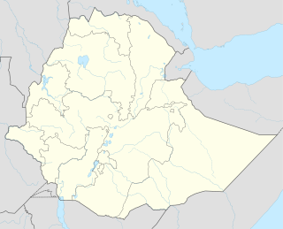
The Afar Region, formerly known as Region 2, is a regional state in northeastern Ethiopia and the homeland of the Afar people. Its capital is the planned city of Semera, which lies on the paved Awash–Assab highway.

Awsi Rasu is a zone in Afar Region of Ethiopia. This zone is bordered on the south by Administrative Zone 3, on the southwest by Administrative Zone 5, on the west by the Amhara Region, on the northwest by Administrative Zone 4, on the north by Administrative Zone 2, on the northeast by Eritrea, and on the east by Djibouti.

Gabi Rasu is a zone in Afar Region of Ethiopia. This zone is bordered on the south by the Oromia Region, on the southwest by the Amhara Region, on the west by the Administrative Zone 5, on the north by Administrative Zone 1, and on the east by the Somali Region.
Asayita is one of the Districts of Ethiopia, or woredas in the Afar Region of Ethiopia. Part of the Administrative Zone 1, Asayita is bordered on the south by Afambo, on the west by Dubti, then on the north by the Awash River which separates it from Elidar, and on the east by Djibouti. The major town in Asayita is Asayita.
Afambo is a woreda in Afar Region, Ethiopia. It is named after Lake Afambo, located at the border of this woreda with Asayita, near the international border with Djibouti. Part of the Administrative Zone 1, Afambo is bordered on the south by the Somali Region, on the west by Dubti, on the north by Asayita, and on the east by Djibouti. The largest town in this woreda is Afambo.
Mille is a woreda of Awsi Rasu within Afar Region, Ethiopia. It is named for the Mille River, a tributary of the Awash River. Mille is bordered on the south by the Administrative Zone 3, on the southwest by Administrative Zone 5, on the west by the Amhara Region, on the northwest by Chifra, on the northeast by Dubti, and on the southeast by the Somali Region. Towns in Mille include Mille and Eli Wuha.
Elidar is a woreda in Afar Region, Ethiopia. Part of the Administrative Zone 1, Elidar is bordered on the south by the Awash River which separates it from Asayita, on the west by Dubti, on the northwest by Kori, on the north by the Administrative Zone 2, on the northeast by Eritrea, and on the east by Djibouti. Towns in Elidar include Bure, Diche Oto, Elidar and Manda.
Chifra is a woreda in Afar Region, Ethiopia. Part of the Administrative Zone 1, Chifra is located near the base of the eastern escarpment of the Ethiopian highlands and bordered on the south by Mille, on the west by the Amhara Region, on the north by the Administrative Zone 4, and on the east by Dubti; the Logiya River defines part of the boundary with Zone 4. The administrative center of Chifra is Chifra.
Berahle is a woreda in Afar Region, Ethiopia. Part of the Administrative Zone 2, Berahle's territory includes part of the Afar Depression. This woreda is bordered on the south by Afdera and Abala, on the southwest by the Tigray Region, on the west by Koneba, on the north by Dallol, and on the northeast by Eritrea. Towns in Berahle include Berhale and Tiyarabora.
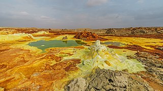
Dallol is a woreda in Afar Region, Ethiopia. This woreda is named for the former mining settlement of Dallol, which set the record for the hottest inhabited place on Earth, with an average temperature of 34 °C. Located at the northernmost point of the Administrative Zone 2, Dallol's territory includes part of the Afar Depression. This woreda is bordered on the south by Koneba, on the west by the Tigray Region, on the north by Eritrea, and on the east and south by Berhale. Detailed information is not available for the settlements in this woreda.
Afdera is one of the Districts of Ethiopia, or woredas, in the Afar Region of Ethiopia. It is named after the saline Lake Afdera, located in the southern part of the Afar Depression. Part of the Administrative Zone 2, Afdera is bordered on the southwest by the Administrative Zone 4, on the west by Erebti and Abala, on the north by Berhale, on the northeast by Eritrea, and on the southeast by Administrative Zone 1. The largest town of this woreda is Afdera.
Amibara is a woreda in Afar Region, Ethiopia. Part of the Administrative Zone 3, Amibara is bordered on the south by Awash Fentale, on the west by the Awash River which separates it from Dulecha, on the northwest by the Administrative Zone 5, on the north by Gewane, on the east by the Somali Region, and on the southeast by Oromia Region. Towns in Amibara include Awash Arba, Awash Sheleko, Melka Sedi and Melka Were.
Awash Fentale is one of the Districts of Ethiopia, or woredas in the Afar Region of Ethiopia. Part of the Administrative Zone 3, Awash Fentale is bordered on the south by the Oromia Region, on the west by the Amhara Region, on the north by Dulecha, and on the east by Amibara. Towns in Awash Fentale include Awash Sebat Kilo and Sabure.
Dulecha is one of the Districts of Ethiopia, or woredas, in the Afar Region of Ethiopia. Part of the Administrative Zone 3, Dulecha is bordered on the south by Awash Fentale, on the west by the Argobba special woreda, on the north by the Administrative Zone 5, and on the east by the Awash River which separates it from Amibara. The largest settlement in Dulecha is Dulecha.
Bure Mudaytu is one of the Districts of Ethiopia, or woredas in the Afar Region of Ethiopia. Part of the Administrative Zone 3, Bure Mudaytu stretches along a narrow band covering the marshy lowlands along the Awash River, with the Administrative Zone 5 to the west and Gewane to the east. The administrative center of this woreda is Debel.
Teru is one of the Districts of Ethiopia, or woredas, in the Afar Region of Ethiopia. Part of the Administrative Zone 4, Teru is bordered on the south by Aura, on the southwest by Gulina, on the west by Yalo, and on the north and east by the Administrative Zone 2. The major settlement in this woreda is Alelo.
Telalak is one of the Districts of Ethiopia, or woredas, in the Afar Region of Ethiopia. Part of the Administrative Zone 5, Telalak is located near the base of the eastern escarpment of the Ethiopian highlands, and bordered on the south by Dewe, on the west by the Amhara Region, on the north by the Administrative Zone 1, and on the east by the Administrative Zone 3. The largest settlement in this woreda is Namelafen.
Dewe is one of the Districts of Ethiopia, or woredas, in the Afar Region of Ethiopia. Part of the Administrative Zone 5, Dewe is located near the base of the eastern escarpment of the Ethiopian highlands, and bordered on the south by the Borkana River which separates it from Dalifage and Hadele Ele, on the west by the Amhara Region, on the north by Telalak, and on the east by Administrative Zone 3. The major settlement in this woreda is Wedarage. Dewe was the seat of the Sultanate of Dewe, one of the Afar's traditional sultanates in the Afar Region.
Simurobi Gele'alo is one of the Districts of Ethiopia, or woredas, in the Afar Region of Ethiopia. Part of the Administrative Zone 5, Simurobi Gele'alo is located near the base of the eastern escarpment of the Ethiopian highlands, and bordered on the west by the Amhara Region, on the north by Hadele Ele, and on the east and south by the Administrative Zone 3; the Awash River defines a part of the southern end of the eastern boundary of this woreda with Administrative Zone 3. The major settlement in this woreda is Kumame.
Gewane is a town in north-eastern Ethiopia. Located in Administrative Zone 3 of the Afar Region, it has an elevation of 618 meters above sea level. Gewane is locally known as New Gewane, 2 kilometers east of the original settlement known as Old Gewane; the town was relocated astride the main, all-weather highway. It is the administrative center of Gewane woreda.