
Mahendra Bir Bikram Shah Dev was King of Nepal from 13 March 1955 until his death in 1972, which was due to heart attack as told in an interview by his personal physician Dr. Mrigendra Raj Pandey. Following the 1960 coup d'état, he established the partyless Panchayat system which governed the country for 28 years until the introduction of multiparty democracy in 1990. During his reign, Nepal experienced a period of industrial, political and economic change which opened it to the rest of the world for the first time after the 104-year-long reign of the Rana rulers, who kept the country under an isolationist policy, came to an end in 1951.

Chitwan District is one of 77 districts of Nepal, and takes up the southwestern corner of Bagmati Province. Bharatpur, largest city of Nepal after Kathmandu, is its administrative centre. It covers 2,238.39 km2 (864.25 sq mi), and in 2011 had a population of 579,984 people. Bharatpur is the commercial and service centre of South Central Nepal and a major destination for higher education, health care and transportation in the region. Chitwan lies in the Terai region of Nepal. It is in the drainage basin of the Gandaki River and is roughly triangular, taking that river as its meandering northwestern border, and a modest watershed border, with India, as the basis of its southern limit. Local government: Bharatpur Metropolitan, Rapti Municipality, Ratnanagar Municipality, Kalika Municipality, Khairahani Municipality, Madi Municipality, Ikshyakamana Gaupalika

Saptari, a part of Madhesh Province, is one of the seventy-seven districts of Nepal. Its district headquarter is Rajbiraj. Saptari is an Outer Terai district. This district covers an area of 1,363 km2 (526 sq mi) and has a population (2011) of 639,284 which makes it the 10th most populated district of Nepal. Saptari is renowned for its agricultural output, and is bordered on the east by the massive Sapta Koshi river.

Mahendranagar, officially known as Bhimdattanagar, is a municipality in Kanchanpur District of Sudurpashchim Province, Nepal. The city and the municipality were named Mahendranagar in honour of the late King Mahendra of Nepal. After becoming a republic in 2008, the Mahendranagar municipality name was changed to Bhimdatta municipality in honour of the revolutionary farmer leader Bhimdatta Panta. It is surrounded by Bedkot Municipality in the east, Dadeldhura District in the north, Shuklaphanta National Park in the south and Uttarakhand, India in the west.
Triyuga is one of eight municipalities of Udayapur district of the Koshi Pradesh of Nepal. Gaighat is the headquarter of the municipality. At the 1991 Nepal census, it had a population of 55,291. The 2011 Nepal census counted 87,557 inhabitants. According to the 2021 Nepal census the initial population of the municipality is 104,375. It is divided into 16 wards. Triyuga Municipality was established on B.S. Chaitra 13, 2053. It was named after Triyuga River. A river which flows through the town. Triyuga is the 3rd largest municipality in Nepal and 1st largest in Koshi Pradesh in term of size (area). The total area of the municipality is 547.43 square kilometres (211.36 sq mi)

Koteshwor is a place, located in Kathmandu District. In 1991, Kathmandu Metropolitan City was expanded by incorporating Koteshwor as Ward No. 32. It encompasses 395 hectares and is bounded by the Manohara river in the east and south, the Bagmati river in the west, and share borders with Gothatar in the north, Madhyapur Thimi municipality of Bhaktapur District in east and Lalitpur metropolitan city in the south. With respect to basic services, almost all homes in the ward have access to electricity, but the same cannot be said about drinking water. At the time of the 1991 Nepal census it had a population of 5,787 living in 1,154 households. The ward contains 8,716 households. The population in 2001 was 35,184.
Mirchaiya formerly known as Ramnagar Mirchaiya is a municipality in Siraha District in the Madhesh Province of south-eastern Nepal. The municipality was established on 18 May 2014 by merging the existing Rampur Birta, Malhaniyakhori, Radhopur, Ramnagar Mirchaiya, Phulbariya, Sitapur PraDa and Maheshpur Gamharia Village Development Committees. At the time of the 2017 municipality records, it had a population of approx. 52,000 people living in approx 8,496 individual households. This is one of the main business markets for Katari and the southern part of the Siraha district. Raw material produced here includes padday, miazem, and sugar cane.
Nargho is a village development committee in Saptari District in the Sagarmatha Zone of southeastern Nepal. At the time of the 1991 Nepal census it had a population of 4640 people living in 960 households. Different caste people like jha, yadav, mandal, sha, ram, karn, paswan, sharma, dom, shada etc., used to live in village. It consists of four subvillages. It has three small bazaars but it does not have good road facility. Most of the people are farmers and they grow paddy, wheat, pulses, vegetables, etc. Some of the people used to depend on animal husbandry and fishery to survive.
Beldandi is a rural municipality in Kanchanpur District in Sudurpashchim Province of southwestern Nepal named after the former Village Development Committee. At the time of the 1991 Nepal census the VDC had a population of 9301 people living in 1483 individual households. According to the Nepal census 2011 the municipality had 3022 individual households and a population of 21,959. In the north and west, Beldandi is surrounded by Suklaphatha national park. To the east lies Belauri Municipality. On the south, it borders India.
Meghauli is a village and former Village Development Committee that is now part of Bharatpur Metropolitan City in Bagmati Province of central Nepal.
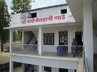
Naya Belhani is a village development committee in Nawalparasi District in the Lumbini Zone of western Nepal. At the time of the 1991 Nepal census it had a population of 9786 people living in 1795 individual households. Naya Belhani is divided into 9 wards, among which ward number 9, Arunkhola is the center of the VDC, which is considered one of an emerging business market of the Nawalparasi district. The VDC's main interesting factor is divided into two parts by Aarungkhola river and East West highway. The river is partition 6, 7 & 9 ward east region and 1,2,3,4,5,8 west region.

Kawasoti (Nepali: कावासोती) is a municipality in Nawalpur District, Gandaki Province, Nepal. It is 31 km (19 mi) west of Bharatpur and 85 km (53 mi) east of Butwal, approximately on the middle of Mahendra Highway. The Naryani River flows south of it, and the Mahabharat Range is north of it.

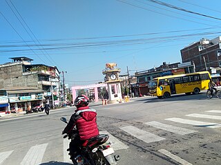
Arunkhola is a town situated on the bank of the river Arun before as Naya Belhani VDC Ward No. 8 of Nawalparasi, but now as Madhyabindu Municipality, ward no. 10, Nawalpur District of Western Nepal. It is also known as Aarungkhola, Aarunkhola(Nepali: आरुणखोला) and Bhagra. It is an emerging business hub of the district.
Gaindakot is a municipality in Nawalpur District in the Lumbini Zone of southern Nepal. It became a municipality in May 2014 by merging the existing Mukundapur, Amarapuri, and Gaindakot VDCs. It was again expanded by merging Ratanpur VDC. It is situated on the shore of Narayani River in the lap of Maula Kalika temple. So this place has a great possibility of tourism development. At the time of the 2011 Nepal census, it had a population of 58,841 and 13,623 individual households according to 2011 Nepal census. Contributed in the article by Prashant Subedi
Kathauna Bazar is a city in Shambhunath Municipality Ward No. 6, in the Saptari district of Nepal. It is 20 km east of Lahan Municipality, and is the central city of Shambhunath Municipality. Shambhunath municipality's head office is located at Kathauna Bazar. At the time of the 1991 Nepal census it had a population of 5167 people, living in 933 individual households.

Dakneshwori Municipality is located in Saptari District in Madhesh Province of Nepal. It was formed in 2016 occupying current 10 sections (wards) merging previous Kabilasha, Hariraha, Tarhi, Bhuthi, Pato, Aurahi, Brahampur, Gamahariya Parwaha, Patthargada and Banaula VDCs. It occupies an area of 69.11 km2 with a total population of 44,782. Dakneshwori Municipality is named after the famous temple Dakneshwori Bhagwati located at ward no. 5, Pato.
Khadak Municipality is located in Saptari District in the Province 2 of Nepal. It was formed in 2016 occupying current 11 sections (wards) merging previous Siswa Belhi, Banarjhula, Pansera, Khojpur, Kalyanpur, Fulbariya, Mainasarsabahu and Banauli VDCs, residing its head office at Kalyanpur Bazaar. It occupies an area of 96.77 km2 with a total population of 45,367.
Pacharauta is a municipality in Bara District in Province No. 2 of South-Eastern Nepal. It was formed in 2016 occupying current 9 sections (wards) from previous 9 former VDCs. It occupies an area of 44.01 km2 with a total population of 34,175.

