Related Research Articles

The Wadiyar dynasty, also referred to as the Wadiyars of Mysore, is a late-medieval Indian royal family of former maharajas of Mysore from the Urs clan originally based in Mysore city.

Vani Vilasa Sagara, popularly known as Mari Kanive is a dam in Hiriyur Taluk, Chitradurga District, in the Indian state of Karnataka. It is located about 21 km west of Hiriyur, 55 km south of Chitradurga, and 180 km north-west of Bengaluru.
The University of Mysore is a public state university in Mysore, Karnataka, India. The university was founded during the reign of Maharaja Krishnaraja Wadiyar IV and the premiership of Sir M. Visvesvaraya. The university is recognised by the University Grants Commission for offering higher studies degree courses on-campus as well as online. It was inaugurated on 27 July 1916. Its first chancellor was the maharaja himself; the first Vice-Chancellor was H. V. Nanjundaiah. This was the first university outside of British administered Indian provinces, the sixth in the Indian subcontinent as a whole, and the first in Karnataka. It is a state university of the affiliating type, and was deemed autonomous within the Republic of India on 3 March 1956, when it gained recognition from the University Grants Commission.

The Chamundi Hills are located 13 km east of Mysore, Karnataka, India. The name comes from the Chamundeshwari Temple at the peak. The average elevation is 1,060 metres (3,480 ft).
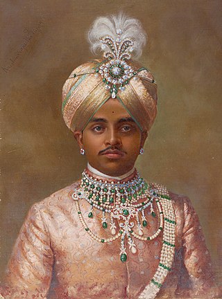
Chamarajendra Wadiyar X was the twenty-third Maharaja of Mysore between 1868 and 1894.

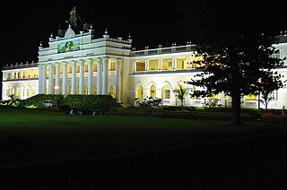
Mysore Palace, also known as Amba Vilas Palace, is a historical palace and a royal residence. It is located in Mysore, Karnataka, India. It used to be the official residence of the Wadiyar dynasty and the seat of the Kingdom of Mysore. The palace is in the centre of Mysore, and faces the Chamundi Hills eastward. Mysore is commonly described as the 'City of the Palaces', and there are seven palaces including this one. However, the Mysore Palace refers specifically to the one within the new fort.
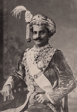
Krishnaraja Wadiyar IV (4 June 1884 – 3 August 1940) was the twenty-fourth Maharaja of Mysore, reigning from 1902 until his death in 1940.
The maharaja of Mysore was the king and principal ruler of the Kingdom of Mysore and briefly of Mysore State in the Indian Dominion roughly between the mid- to late-1300s and 1950. The maharaja's consort was called the maharani of Mysore.

SirMirza Muhammad IsmailAmin-ul-Mulq KCIE OBE CStJ was an Indian statesman and police officer who served as the Diwan of Mysore, Jaipur, and Hyderabad.
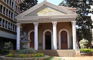
The Daly Memorial Hall, is a heritage building located in Bangalore, Karnataka that houses the Mythic Society. The Mythic society, founded in 1909, is a pioneering institution of Catholic-Indic studies in South India. Daly Memorial Hall, built at a cost of INR 24,783, was inaugurated on 25 July 1917 by the Kanteerava Narasimharaja Wadiyar (the Yuvaraja of Mysore. The Hall is named after Sir Hugh Daly, who served as the Resident of Mysore State and Chief Commissioner of Coorg.

Krishnaraja Wodeyar III was an Indian king who was the twenty-second Maharaja of Mysore. He ruled the kingdom for nearly seventy years, from 30 June 1799 to 27 March 1868, for a good portion of the latter period of which he was merely a nominal ruler. He is known for his contribution and patronage to different arts and music during his reign. He was succeeded by his biological grandson and adopted son, Chamarajendra Wadiyar X.
Ballal Circle, officially known as Ashoka Circle, is one of the major traffic junction in Mysore city, Karnataka state, India.

Manasagangotri is a suburb of Mysore city in Mysore district of Karnataka state, India. Mysore University and its various departments are located in this area.

Krishnaraja Boulevard is an important street of Mysore city in Karnataka state of India.

Chamarajapuram is one of the earliest settlements and localities in Mysore, Karnataka, India, located in the centre of Mysore city. Initially an agraharam inhabited by the Mysore nobility, parts of it were later allotted other local dwellers as well.

Madhuvana Mysore Royal Cemetery is a site in Mysuru where many members of the Wadiyar royal family were cremated. It is located on Mysuru-Nanjangud road, and is on five acres of land. It is also known as "Khasa Brindavan", or "private garden". The cemetery is in the process of becoming a tourist attraction.

K. Thuppul Narasimha Iyengar Bhashyam was an Indian Politician from the state of Mysore.

Chamaraja Road or Chamarajendra double Road is an important main street in downtown Mysore city, Karnataka state, India.
Agrahara Circle, officially known as N. Madhava Rao Circle, is a street circle and a suburb in the southern Indian city of Mysore in Karnataka.
Mirza Road is a road in Mysore city, Karnataka state, India.
References
- ↑ "Agrahara ಅಗ್ರಹಾರ Chamrajpura Mysuru, Karnataka India". Google Maps. Retrieved 19 March 2022.
- 1 2 3 4 Satya, Gouri (8 August 2021). "He Builds An Agrahara, Makes His House A Temple". Star of Mysore. Archived from the original on 8 August 2021. Retrieved 19 March 2022.
- ↑ Satya, Gouri (16 February 2020). "How Mummadi And His Queens Built Mysore". Star of Mysore. Archived from the original on 17 February 2020. Retrieved 1 March 2022.
- 1 2 Satya, Gouri. "Can You Imagine Building A House For Just Rs. 5,000?". Star of Mysore. Archived from the original on 21 November 2021. Retrieved 1 March 2022.
- ↑ Biradar, Anjana Vasant; Papu, Sapna (2019). "The Agraharas of Mysuru". In Agrawal, Avlokita; Gupta, Rajat (eds.). Revisiting the Role of Architecture for 'Surviving' Development. 53rd International Conference of the Architectural Science Association (PDF). Roorkee, India: Architectural Science Association (ANZAScA). pp. 451–460. Retrieved 19 March 2022.
- ↑ Kadati Reddera Basavaraja (1984). History and Culture of Karnataka: Early Times to Unification. Chalukya Publications. p. 334.
- 1 2 "Landmarks for Dewans and their services forgotten". Star of Mysore. 2 November 2020. Retrieved 1 March 2022.
- ↑ "Two-wheelers damaged as tree branch falls near Agrahara Circle". Star of Mysore. 15 October 2020. Retrieved 1 March 2022.
- ↑ "Kattappa's controversial statement: City theatre stops screening of Tamil movie". Star of Mysore. 23 April 2017. Retrieved 1 March 2022.