A caldera is a large cauldron-like hollow that forms shortly after the emptying of a magma chamber in a volcano eruption. When large volumes of magma are erupted over a short time, structural support for the rock above the magma chamber is gone. The ground surface then collapses into the emptied or partially emptied magma chamber, leaving a large depression at the surface. Although sometimes described as a crater, the feature is actually a type of sinkhole, as it is formed through subsidence and collapse rather than an explosion or impact. Compared to the thousands of volcanic eruptions that occur each century, the formation of a caldera is a rare event, occurring only a few times per century. Only seven caldera-forming collapses are known to have occurred between 1911 and 2016. More recently, a caldera collapse occurred at Kīlauea, Hawaii in 2018.

Teide, or Mount Teide, is a volcano on Tenerife in the Canary Islands, Spain. Its summit is the highest point in Spain and the highest point above sea level in the islands of the Atlantic. If measured from the ocean floor, its height of 7,500 m (24,600 ft) makes Teide the third-highest volcano in the world, and is described by UNESCO and NASA as Earth's third-tallest volcanic structure. Teide's elevation above sea level makes Tenerife the tenth highest island in the world.
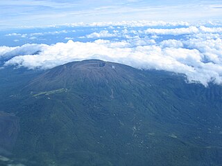
The Santa Ana Volcano or Ilamatepec is a large stratovolcano located in the Santa Ana department of El Salvador. At 2,381 metres (7,812 ft) above sea level, it is the highest volcano in the country. It is located immediately west of Coatepeque Caldera.

The Almolonga volcano, also called "Cerro Quemado" or "La Muela" due to its distinct shape, is an andesitic stratovolcano in the south-western department of Quetzaltenango in Guatemala. The volcano is located near the town of Almolonga, just south of Quetzaltenango, Guatemala's second largest city.

Maipo is a stratovolcano in the Andes, lying on the border between Argentina and Chile. It is located 90 km (56 mi) south of Tupungato and about 100 km (62 mi) southeast of Santiago. It has a symmetrical, conical volcanic shape, and is among the southernmost 5,000 metre peaks in the Andes.

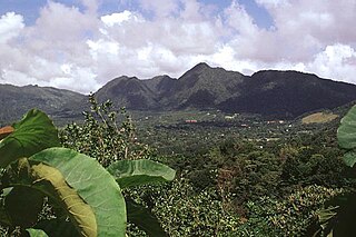
The San Salvador Volcano is a stratovolcano situated northwest to the city of San Salvador. The crater has been nearly filled with a relatively newer edifice, the Boquerón volcano. San Salvador is adjacent to the volcano and the western section of the city actually lies among its slopes. Due to this close proximity, any geological activity of the volcano, whether eruptive or not, has the potential to result in catastrophic destruction and death to the city. Despite this, the volcano is iconic of the city, and several TV and radio antennas are situated on the El Picacho peaks and the crater of Boqueron. El Picacho, the prominent peak is the highest elevation.
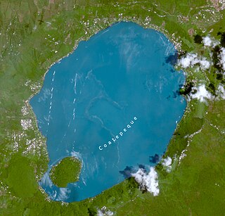
Coatepeque Caldera is a volcanic caldera in El Salvador in Central America. The caldera was formed during a series of rhyolitic explosive eruptions between about 72,000 and 57,000 years ago. Since then, basaltic cinder cones and lava flows formed near the west edge of the caldera, and six rhyodacitic lava domes have formed. The youngest dome, Cerro Pacho, formed after 8000 BC.
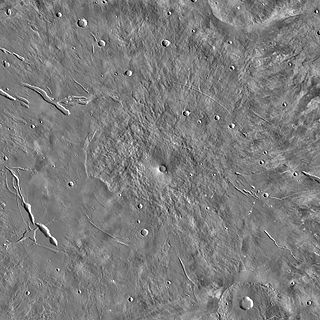
Elysium Mons is a volcano on Mars located in the volcanic province Elysium, at 25.02°N 147.21°E, in the Martian eastern hemisphere. It stands about 12.6 km (41,000 ft) above its base, and about 14.1 km (46,000 ft) above the Martian datum, making it the third tallest Martian mountain in terms of relief and the fourth highest in elevation. Its diameter is about 240 km (150 mi), with a summit caldera about 14 km (8.7 mi) across. It is flanked by the smaller volcanoes Hecates Tholus to the northeast, and Albor Tholus to the southeast.

Zavaritski Caldera is a caldera located in the central part of Simushir Island, Kuril Islands, Russia. Lake Biryuzovoe partially fills the youngest of three nested calderas on the volcano.

Cosigüina is a stratovolcano located in the western part of Nicaragua. It forms a large peninsula extending into the Gulf of Fonseca. The summit is truncated by a large caldera, 2 x 2.4 km in diameter and 500 m deep, holding a substantial crater lake. This cone has grown within an earlier caldera, forming a somma volcano. The earlier caldera rim is still exposed on the north side, but has been buried by the younger cone elsewhere.

Chinameca is a stratovolcano in central-eastern El Salvador. It lies north of San Miguel volcano and rises over the town of Chinameca. The volcano is topped by a 2 kilometres (1.2 mi) wide caldera known as Laguna Seca el Pacayal, and a satellite cone on the west side, Cerro el Limbo, rises higher than the caldera rim. Fumaroles can be found on the north side, and it has been the site of a geothermal exploration program.
El Valle is a stratovolcano in central Panama and is the easternmost volcano along the Central American Volcanic Arc which has been formed by the subduction of the Nazca Plate below Central America. Some time prior to 200,000 years ago, the volcano underwent a huge eruption event that caused the top of the volcano to collapse into the empty magma chamber below forming a large caldera. Several lava domes have developed inside the caldera since the collapse—forming Cerro Pajita, Cerro Gaital and Cerro Caracoral peaks. Prior to research in the early 1990s, it was thought that no active volcanism existed within Panama. But radioactive dates from El Valle show that the volcano last erupted as recently as 200,000 years ago.

Biblis Tholus is an extinct Martian volcano located at 2.55°N 235.62°E, one of two volcanoes near the center of the Tharsis volcanism. Along with Ulysses Tholus, it is almost midway between Olympus Mons and the Tharsis Montes. Biblis Tholus lies in the Tharsis quadrangle. It is approximately 170 kilometers (110 mi) long and 100 kilometers (62 mi) wide, rising about 3 kilometers (1.9 mi) from its surroundings.

The volcanoes of east-central Baja California are located on the Baja California Peninsula near the Gulf of California, in the state of Baja California Sur, in Mexico.
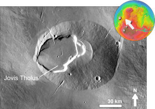
Jovis Tholus is a volcano in the Tharsis quadrangle of Mars located at 18.41° N and 117.41° W. It is 58.0 km across and was named after a classical albedo feature name. It has an elevation of 2,990 metres (9,810 ft).

Ceboruco is a dacitic stratovolcano located in Nayarit, Mexico, northwest of the Trans-Mexican Volcanic Belt. The largest eruption, the Jala Plinian eruption, was around 930 AD ±200, VEI 6, releasing 11 cubic kilometres (2.6 cu mi) of tephra. The most recent and best documented eruption from Ceboruco lasted from 1870–1875, with fumarole activity lasting well into the 20th century. The mountain features one large caldera, created during the Jala eruption, with a smaller crater nested inside that formed when the Dos Equis lava dome collapsed during the Coapales eruption around 1100 AD. Within both of these craters, are several explosive volcanic features, including scoria deposits, lava domes, and pyroclastic domes, or cinder cone volcanoes.
La Reforma is a Plio-Pleistocene caldera on the Baja California Peninsula in Mexico. It is part of eleven volcanoes in Baja California, which formed with the Gulf of California during the Miocene, about ten million years ago. Previously, a volcanic arc had existed on the peninsula. The caldera's basement consists of granites and monzonites, formed between the Cretaceous and the Middle Miocene.

A volcanic crater lake is a lake in a crater that was formed by explosive activity or a collapse during a volcanic eruption.

The Kīlauea Caldera, officially gazetted as Kīlauea Crater, is a caldera located at the summit of Kīlauea, an active shield volcano in the Hawaiian Islands. It has an extreme length of 2.93 mi (4.72 km), an extreme width of 1.95 mi (3.14 km), a circumference of 7.85 mi (12.63 km) and an area of 4.14 sq mi (10.7 km2). It contains Halemaʻumaʻu, an active pit crater near the caldera's southwestern edge.

