La Reforma (caldera)

Last updated

La Reforma
La Reforma, BCS.jpg
The caldera of La Reforma and neighbouring volcanoes
Highest point
Elevation 1,200 m (3,900 ft)
Coordinates 27°30′28.8″N112°23′31.2″W / 27.508000°N 112.392000°W / 27.508000; -112.392000 [1]
Geography
Mexico Baja California Sur location map.svg
Red triangle with thick white border.svg
La Reforma
Mexico relief location map.jpg
Red triangle with thick white border.svg
La Reforma
La Reforma (Mexico)
Geology
Age of rock Plio-Pleistocene
Mountain type Caldera
Last eruption Pleistocene (0.6 Ma)

La Reforma is a Plio-Pleistocene caldera on the Baja California Peninsula in Mexico. It is part of eleven volcanoes in Baja California, which formed with the Gulf of California during the Miocene, about ten million years ago. Previously, a volcanic arc had existed on the peninsula. The caldera's basement consists of granites and monzonites, formed between the Cretaceous and the Middle Miocene.

Contents

The caldera has a diameter of 10 kilometres (6.2 mi) and is surrounded by a rim 100 to 500 metres (330 to 1,640 ft) high; its highest point is 1,200 metres (3,900 ft) high above sea level. The formation of the caldera was accompanied by the eruption of a 5–10 cubic kilometres (1.2–2.4 cu mi) ignimbrite. After the eruption, volcanic activity continued in and around the caldera, forming lava domes, lava flows and a resurgent dome that rises 700 metres (2,300 ft) above the caldera margin.

Other volcanoes in the area include El Aguajito and Tres Virgenes.

Geography and structure

El Virgen, one of the three Virgenes volcanoes to the west of La Reforma LasTresVirgenes06.jpg
El Virgen, one of the three Virgenes volcanoes to the west of La Reforma

La Reforma is located in the municipality Mulegé, in east-central Baja California, [2] Mexico, [1] just south of the frontier between the departments Baja California and Baja California Sur, [3] and 20 kilometres (12 mi) north of Santa Rosalía. [4] Other volcanic centres in the neighbourhood are Tres Virgenes and El Aguajito (first identified as "Santa Ana caldera" in 1984), [5] west of La Reforma. [6] Offshore east of La Reforma lies the Virgenes High, a submarine elevated platform, [7] probably associated with basaltic intrusions at the intersection of two volcanic ridges. Isla Tortuga, a volcanic island formed on a fracture zone, is also to the east of La Reforma. [8]

The La Reforma caldera has a diameter of 10 kilometres (6.2 mi), [2] and the height of its rim ranges from 100 to 500 metres (330 to 1,640 ft). [9] It is a semicircular structure around Cabo Virgenes, which reaches the Gulf of California at La Reforma in the northwest and Punta Las Cuevas in the southeast. [10] [1] A tectonic block inside the caldera rises 700 metres (2,300 ft) above the rim of the caldera; it is a resurgent dome formed by welded tuff. [3] The highest point of the dome is 1,200 metres (3,900 ft). [9]

Alternative theories are that La Reforma is a dome which was eroded to form a circular pattern or a set of tectonic blocks. Although the dome was thought to be formed by the older Comondú volcanics, it appears to be a product of La Reforma activity. [3]

Geology

La Reforma is one of 11 volcanic centres in Baja California. In addition to La Reforma-Tres Virgenes, the other centres are Cerro Prieto, El Pinacate, the San Quintin volcanic field, the Puertecitos volcanic province, San Luis Island, the Jaraguay volcanic field, the San Borja volcanic field, Punta Púlpito, the Mencenares volcanic complex and La Purísima. [11]

Subduction of the Guadalupe Plate/Farallon Plate beneath Baja California [12] was prevalent in the region until 12,5–11 million years ago; volcanic activity since then is due to tectonic changes associated with the development of the Gulf of California. [3] [13] Earlier subduction-related volcanism during the Miocene formed the volcanic deposits of the Comondú Group. [12]

When subduction was active, it triggered the formation of andesitic rocks known as "Andesite of Sierra Santa Lucía" in the area around La Reforma. [14] These are the local manifestations of Comondú Group volcanics [15] from activity occurring 24 to 13 million years ago. The last subduction-related volcanism, producing Santa Rosalía dacite, was between 13 and 12 million years ago. Subsequently, rifting in the Santa Rosalía Basin was accompanied by volcanism which laid down the basalts-basaltic andesite of the Boleo Formation (11-9 million years ago), the El Morro tuff (9-8 million years ago) and the Cerro San Lucas unit (9.5–7.7 million years ago). [14]

Volcanism in the area is linked to the formation of the Santa Rosalía Basin, expressed as the Gulf of California, about ten million years ago as part of the tectonic activity of the Basin and Range Province. The gulf's formation was accompanied by volcanic activity, calc-alkaline at first and later alkaline and tholeiitic. [16] Interaction between the San Andreas Fault and the East Pacific Rise triggered the formation of a transform boundary in the gulf 3.5 million years ago. [17] Baja California is currently moving northwest at a rate of 5.6 centimetres per year (2.2 in/year). [18] As part of this movement of the Earth's tectonic plates, the Santa Rosalía Basin formed through crustal extension and was filled by a number of Miocene-Pleistocene layers of rock, some of which are exposed in La Reforma. [16] The basin's formation was influenced by faults running northwest to southeast, and other fault systems are also active in the area. [19]

Rocks

Based on outcrop analysis, the crystalline basement composed of granitic and monzonitic rocks, dates to the Cretaceous, [3] the oldest dated sample being 91.2 ± 2 million years old. This rock, a granite, may be part of a plutonic basement. [15] Younger basement rocks comprise Miocene marine sediments and volcanics pertaining to the Comondú Group. [9] Andesite of Sierra Santa Lucía is found west-southwest of the Santa Rosalía Basin. [14] The basaltic La Esperanza formation is also in the area. [20]

AgeFormationLithologiesNotes
HoloceneFluvial sediments
Late PleistoceneVolcanicsBasaltic cones
Middle Pleistocene Rhyolitic lava flows
[2]
Early PleistoceneIgnimbrites and pantellerite tuff
PlioceneAsh and pumice flows, basaltic dykes
Late MioceneMarine sediments
[9]
Middle to Late Miocene Comondú Group Andesite lava flows
Early to Middle MioceneAndesite breccia
Oligocene to Early Miocene Fluvial sandstones and conglomerates, felsic tuffs
CretaceousCrystalline basement Granites & monzonites
[3]

Composition

Lava flow deposits are composed of andesite, basalt and dacite and lava domes consist of rhyolite. [1] Plagioclase, apatite, magnetite and zirconia are the common mineral components of the rocks. [23] The most common minerals in the ignimbrites are feldspar and clinopyroxene, while fayalite is rare. [24] In addition to these minerals, the youngest rocks are andesites which contain amphibole. [25] The area contains well-known copper- and manganese-bearing resources in marine sediments that were deposited during the Pliocene. [4] Zinc and cobalt concentrations in the minerals surrounding La Reforma range from 242 to 38,847 and 22 to 17,407 ppm respectively. [14] Some rocks of Pliocene were erupted in a submarine environment and have been converted into palagonite, which has a glassy structure. [23]

The La Reforma volcanic rocks feature an anomalous chemistry resembling the calc-alkaline magma series, even though La Reforma is not a subduction zone volcano. [3] This is consistent with the geochemistry of nearby Tres Virgenes, although one pyroclastic flow at La Reforma was considered peralkaline. [15]

Climate

The climate is arid; average precipitation in the area is 60 millimetres (2.4 in) per year, 40.6 millimetres (1.60 in) of which falls in winter. Most precipitation falls on Tres Virgenes. [10] In Santa Rosalia, average temperatures range from 16.5 °C (61.7 °F) in January to 30.8 °C (87.4 °F) in August. [26]

The area was probably more humid during winter in the Pleistocene and certainly colder; oxygen isotope ratios of Tres Virgenes waters indicate that temperatures during the time of the Wisconsin glaciation were 5–7 °C (9.0–12.6 °F) colder than today. [27]

Eruptive history

Volcanism at La Reforma began during the Pliocene, with ash flows and subaqueous pumice flows. Later activity became subaerial and generated pillow lava. [2] Of the local volcanoes, La Reforma was the first to emerge from the sea. [28] Four to five million years ago, basaltic dykes formed. [10] Volcanic activity at La Reforma occurred between 1.6 and 1.4 million years ago, [29] and at least four ignimbrites have been found there. [9]

A major ignimbrite-forming eruption occurred during the Early Pleistocene, with the formation of pantellerite tuff. [2] The eruption covered about 200 square kilometres (77 sq mi) with 5–10 cubic kilometres (1.2–2.4 cu mi) of ignimbrite. [22] The ignimbrite is rich in fiamme. [9] Andesitic effusive activity occurred on the flanks of the caldera before and after its collapse. [1]

Activity after the caldera's formation created lava domes and rhyolitic lava flows along its ring faults. [2] One flow was dated at 1,090,000 ± 110,000 years old, [1] and the domes are 1.4 to 1.2 million years old. [10] La Reforma eruption products were later partially buried by activity from El Aguajito, [30] where volcanic activity had migrated to. [28] Basaltic cones [2] which erupted 600,000 years ago [10] on the caldera's flanks despite their location are not part of the La Reforma volcano; like Isla Tortuga and Tres Virgenes, they are controlled by the tectonic processes that accompanied the rifting of the Sea of Cortez. [2] Also, rivers deposited sediments inside the caldera itself. [21] Seismic activity still occurs at Tres Virgenes volcano. [3] La Reforma could still experience large scale explosive volcanism, especially in its southwestern part. [23]

Resurgent doming occurred in the centre of the caldera, causing Miocene-age rocks (including diorites) to be exposed at its centre. A combination between this doming and uplift of the surrounding land of the Baja California peninsula raised Pleistocene sea deposits to over 300 metres (980 ft). The average pace of the uplift is 240 millimetres per millennium (9.4 in/ka). [2] Hot springs exist in the area and the chemical and isotope characteristics indicate that a small amount of their water comes from magma, implying that a magma chamber still exists beneath La Reforma. [31] Temperatures of the hot springs range from 21 to 98 °C (70 to 208 °F). [14] Geothermal energy has been harnessed from Tres Virgenes for over ten years; [11] currently, in Baja California Cerro Prieto and Tres Virgenes are the principal sources for geothermal energy, but a number of other sites on the peninsula could be used in the future for power generation. [32]

Related Research Articles

<span class="mw-page-title-main">Baja California peninsula</span> Peninsula on the Pacific coast of Mexico

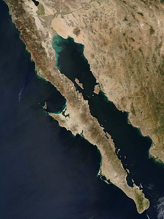
The Baja California peninsula is a peninsula in northwestern Mexico. It separates the Gulf of California from the Pacific Ocean. The peninsula extends from Mexicali, Baja California, in the north to Cabo San Lucas, Baja California Sur, in the south.

<span class="mw-page-title-main">Yellowstone hotspot</span> Volcanic hotspot in the United States

The Yellowstone hotspot is a volcanic hotspot in the United States responsible for large scale volcanism in Idaho, Montana, Nevada, Oregon, and Wyoming, formed as the North American tectonic plate moved over it. It formed the eastern Snake River Plain through a succession of caldera-forming eruptions. The resulting calderas include the Island Park Caldera, Henry's Fork Caldera, and the Bruneau-Jarbidge caldera. The hotspot currently lies under the Yellowstone Caldera. The hotspot's most recent caldera-forming supereruption, known as the Lava Creek Eruption, took place 640,000 years ago and created the Lava Creek Tuff, and the most recent Yellowstone Caldera. The Yellowstone hotspot is one of a few volcanic hotspots underlying the North American tectonic plate; another example is the Anahim hotspot.

<span class="mw-page-title-main">Galán</span> Mountain in Argentina

Cerro Galán is a caldera in the Catamarca Province of Argentina. It is one of the largest exposed calderas in the world and forms part of the Central Volcanic Zone of the Andes, one of the three volcanic belts found in South America. One of several major caldera systems in the Central Volcanic Zone, the mountain is grouped into the Altiplano–Puna volcanic complex.

<span class="mw-page-title-main">Tres Vírgenes</span> Complex of volcanoes located Mulegé Municipality, Mexico

Tres Vírgenes is a complex of volcanoes located in the Mulegé Municipality in the state of Baja California Sur, on the Baja California Peninsula in northwestern Mexico. This Volcano is part of a volcanic ridge that extends from Baja California towards the Guaymas Basin.

<span class="mw-page-title-main">Boot Heel volcanic field</span> Landform in Mexico and United States

The Boot Heel volcanic field is located in the Bootheel region of southwest New Mexico, adjacent areas of southeastern Arizona, and northwest Mexico. The field covers an area of more than 24,000 km2. The field includes nine volcanic calderas ranging in age from 26.9 to 35.3 Ma. Extrusive products include rhyolitic ignimbrites along with basalt, andesite, and rhyolite lava flows. The major ash flow tuff sheets produced, range in volume from 35 to 650 km3.

<span class="mw-page-title-main">Sollipulli</span> Volcanic mountain in Chile

Sollipulli is an ice-filled volcanic caldera and volcanic complex, which lies southeast of the small town of Melipeuco in the La Araucanía Region, Chile. It is part of the Southern Volcanic Zone of the Andes, one of the four volcanic belts in the Andes chain.

<span class="mw-page-title-main">Volcanoes of east-central Baja California</span> Group of volcanoes in the center-east of the Baja California peninsula

The volcanoes of east-central Baja California are located on the Baja California Peninsula near the Gulf of California, in the state of Baja California Sur, in Mexico.

<span class="mw-page-title-main">Puyehue-Cordón Caulle</span> Volcanic complex in Chile

Puyehue and Cordón Caulle are two coalesced volcanic edifices that form a major mountain massif in Puyehue National Park in the Andes of Ranco Province, in the South of Chile. In volcanology this group is known as the Puyehue-Cordón Caulle Volcanic Complex (PCCVC). Four volcanoes constitute the volcanic group or complex, the Cordillera Nevada caldera, the Pliocene Mencheca volcano, Cordón Caulle fissure vents and the Puyehue stratovolcano.

<span class="mw-page-title-main">La Pacana</span> Large Miocene-age caldera in northern Chile

La Pacana is a Miocene age caldera in northern Chile's Antofagasta Region. Part of the Central Volcanic Zone of the Andes, it is part of the Altiplano-Puna volcanic complex, a major caldera and silicic ignimbrite volcanic field. This volcanic field is located in remote regions at the Zapaleri tripoint between Chile, Bolivia and Argentina.

Cerro Guacha is a Miocene caldera in southwestern Bolivia's Sur Lípez Province. Part of the volcanic system of the Andes, it is considered to be part of the Central Volcanic Zone (CVZ), one of the three volcanic arcs of the Andes, and its associated Altiplano-Puna volcanic complex (APVC). A number of volcanic calderas occur within the latter.

<span class="mw-page-title-main">Cerro Panizos</span>

Panizos is a Late Miocene caldera in the Potosí Department of Bolivia and the Jujuy Province of Argentina. It is part of the Altiplano-Puna volcanic complex of the Central Volcanic Zone in the Andes. 50 volcanoes active in recent times are found in the Central Volcanic Zone, and several major caldera complexes are situated in the area. The caldera is located in a difficult-to-access part of the Andes.

<span class="mw-page-title-main">Incapillo</span> Pleistocene caldera in Argentina

Incapillo is a Pleistocene caldera in the La Rioja province of Argentina. It is considered the southernmost volcanic centre in the Central Volcanic Zone (CVZ) of the Andes with Pleistocene activity. Incapillo is one of several ignimbritic or calderic systems that, along with 44 active stratovolcanoes, are part of the CVZ.

Jaraguay volcanic field is a volcanic field in northern Baja California, Mexico.

Jotabeche is a Miocene-Pliocene caldera in the Atacama Region of Chile. It is part of the volcanic Andes, more specifically of the extreme southern end of the Central Volcanic Zone (CVZ). This sector of the Andean Volcanic Belt contains about 44 volcanic centres and numerous more minor volcanic systems, as well as some caldera and ignimbrite systems. Jotabeche is located in a now inactive segment of the CVZ, the Maricunga Belt.

<span class="mw-page-title-main">Las Derrumbadas</span>

Las Derrumbadas is a rhyolitic twin dome volcano in the Mexican state of Puebla. Often overlooked for its proximity to some of the country's most famous mountains —including Cofre de Perote, Sierra Negra and colossal Pico de Orizaba— its two summits are nevertheless within the top 30 of the country's highest mountain peaks.

San Borja volcanic field is a volcanic field in Baja California, northeast of the Vizcaino Peninsula. It is formed by a plateau of lava flows and a number of scoria cones. The field started erupting over twelve million years ago and has endured several changes in regional tectonics.

Vilama is a Miocene caldera in Bolivia and Argentina. Straddling the border between the two countries, it is part of the Central Volcanic Zone, one of the four volcanic belts in the Andes. Vilama is remote and forms part of the Altiplano-Puna volcanic complex, a province of large calderas and associated ignimbrites that were active since about 8 million years ago, sometimes in the form of supervolcanoes.

<span class="mw-page-title-main">Ōkataina Caldera</span> Volcanic caldera in New Zealand

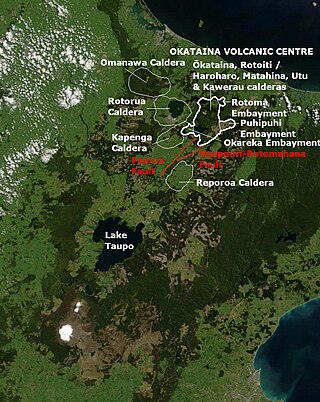
Ōkataina Caldera is a volcanic caldera and its associated volcanoes located in Taupō Volcanic Zone of New Zealand's North Island. It has several actual or postulated sub calderas. The Ōkataina Caldera is just east of the smaller Rotorua Caldera and southwest of the much smaller Rotomā Embayment which is usually regarded as an associated volcano. It shows high rates of explosive rhyolitic volcanism although its last eruption was basaltic. The postulated Haroharo Caldera contained within it has sometimes been described in almost interchangeable terms with the Ōkataina Caldera or volcanic complex or centre and by other authors as a separate complex. Since 2010 other terms such as the Haroharo vent alignment, Utu Caldera, Matahina Caldera, Rotoiti Caldera and a postulated Kawerau Caldera are usually used rather than a Haroharo Caldera classification.

The Tauranga Volcanic Centre is a geologic region in New Zealand's Bay of Plenty. It extends from the southern end of Waihi Beach and from the old volcanoes of the Coromandel Peninsula that make up the northern part of the Kaimai Range, towards the Taupō Volcanic Zone.

<span class="mw-page-title-main">Coromandel Volcanic Zone</span> Extinct volcanic area in New Zealand

The Coromandel Volcanic Zone (CVZ) is an extinct intraplate volcanic arc stretching from Great Barrier Island in the north, through the Coromandel Peninsula, to the Kaimai Range in the south. The area of transition between it and the newer and still active Taupō Volcanic Zone is now usually separated and is called the Tauranga Volcanic Centre. Its volcanic activity was associated with the formation and most active period of the Hauraki Rift.

References

  1. 1 2 3 4 5 6 "La Reforma". Global Volcanism Program . Smithsonian Institution.
  2. 1 2 3 4 5 6 7 8 9 10 Demant, Alain; Ortlieb, Luc (January 1981). "Plio-pleistocene volcano-tectonic evolution of la Reforma Caldera, Baja California, Mexico". Tectonophysics. 71 (1–4): 194. doi:10.1016/0040-1951(81)90065-2.
  3. 1 2 3 4 5 6 7 8 Hook, Simon J.; Dmochowski, Jane E.; Howard, Keith A.; Rowan, Lawrence C.; Karlstrom, Karl E.; Stock, Joann M. (April 2005). "Mapping variations in weight percent[ sic ] silica measured from multispectral thermal infrared imagery—Examples from the Hiller Mountains, Nevada, USA and Tres Virgenes-La Reforma, Baja California Sur, Mexico". Remote Sensing of Environment. 95 (3): 279. doi:10.1016/j.rse.2004.11.020.
  4. 1 2 Demant 1984, p. 75.
  5. Garduño Monroy, Vargas Ledezma & Campos Enriquez 1993, p. 47.
  6. Garduño Monroy, Vargas Ledezma & Campos Enriquez 1993, p. 48.
  7. Fabriol et al. 1999, p. 79.
  8. Fabriol et al. 1999, p. 90.
  9. 1 2 3 4 5 6 García Sánchez, Laura; et al. (2015-12-15). "Stratigraphy of Reforma Caldera, Baja California Sur, Mexico". AGU.{{cite journal}}: Cite journal requires |journal= (help)
  10. 1 2 3 4 5 6 7 Portugal et al. 2000, p. 227.
  11. 1 2 Arango Galván, Claudia; Prol Ledesma, Rosa María; Torres Vera, Marco Antonio (May 2015). "Geothermal prospects in the Baja California Peninsula". Geothermics. 55: 42. doi: 10.1016/j.geothermics.2015.01.005 .
  12. 1 2 Aguillón-Robles, Alfredo; Calmus, Thierry; Benoit, Mathieu; Bellon, Hervé; Maury, René C.; Cotten, Joseph; Bourgois, Jacques; Michaud, François (2001-06-01). "Late Miocene adakites and Nb-enriched basalts from Vizcaino Peninsula, Mexico: Indicators of East Pacific Rise subduction below southern Baja California?". Geology. 29 (6): 531–534. doi:10.1130/0091-7613(2001)029<0531:LMAANE>2.0.CO;2. ISSN   0091-7613.
  13. 1 2 3 4 Umhoefer, Paul; Dorsey, Rebecca; Willsey, Shawn; Mayer, Larry; Renne, Paul (October 2001). "Stratigraphy and geochronology of the Comondú Group near Loreto, Baja California Sur, Mexico". Sedimentary Geology. 144 (1–2): 125–147. doi:10.1016/S0037-0738(01)00138-5 . Retrieved 2017-01-27.
  14. 1 2 3 4 5 Del Rio Salas, Rafael; Ochoa Landín, Lucas; Eastoe, Christopher J.; Ruiz, Joaquín; Meza Figueroa, Diana; Valencia-Moreno, Martín; Zúñiga Hernández, Hugo; Zúñiga Hernández, Luis; Moreno Rodríguez, Verónica (2013-12-01). "Génesis de la mineralización de óxidos de manganeso en la región de Boleo y la Península de Concepción, Baja California Sur: restricciones a partir de isótopos de Pb-Sr y geoquímica de elementos de las tierras raras". Revista Mexicana de Ciencias Geológicas. 30 (3): 482–499. ISSN   1026-8774.
  15. 1 2 3 Wong, Victor; Munguía, Luis (2006-03-01). "Seismicity, focal mechanisms, and stress distribution in the Tres Vírgenes volcanic and geothermal region, Baja California Sur, Mexico". Geofísica Internacional. 45 (1): 23–37. doi:10.22201/igeof.00167169p.2006.45.1.190. ISSN   0016-7169.
  16. 1 2 Garduño Monroy, Vargas Ledezma & Campos Enriquez 1993, p. 49.
  17. Zanchi, Andrea (December 1994). "The opening of the Gulf of California near Loreto, Baja California, Mexico: from basin and range extension to transtensional tectonics". Journal of Structural Geology. 16 (12): 1621. doi:10.1016/0191-8141(94)90131-7.
  18. Fabriol, Hubert; Delgado-Argote, Luis A; Dañobeitia, Juan José; Córdoba, Diego; González, Antonio; Garcı́a Abdeslem, Juan; Bartolomé, Rafael; Martı́n Atienza, Beatriz; Frias Camacho, Vı́ctor (November 1999). "Backscattering and geophysical features of volcanic ridges offshore Santa Rosalia, Baja California Sur, Gulf of California, Mexico". Journal of Volcanology and Geothermal Research. 93 (1–2): 76. doi:10.1016/S0377-0273(99)00084-0.
  19. Portugal et al. 2000, p. 225.
  20. Demant 1984, p. 78.
  21. 1 2 Garduño Monroy, Vargas Ledezma & Campos Enriquez 1993, p. 57.
  22. 1 2 Demant 1984, p. 79.
  23. 1 2 3 Demant 1984, p. 83.
  24. Demant 1984, p. 85.
  25. Demant 1984, p. 87.
  26. "NORMALES CLIMATOLÓGICAS-SANTA ROSALIA". Climatología (in Spanish). Servicio Meteorológico Nacional. Archived from the original (txt) on 4 March 2016. Retrieved 2 February 2017.
  27. Birkle, Peter; Marín, Enrique Portugal; Pinti, Daniele L.; Castro, M. Clara (February 2016). "Origin and evolution of geothermal fluids from Las Tres Vírgenes and Cerro Prieto fields, Mexico – Co-genetic volcanic activity and paleoclimatic constraints". Applied Geochemistry. 65: 46. doi:10.1016/j.apgeochem.2015.10.009.
  28. 1 2 Garduño Monroy, Vargas Ledezma & Campos Enriquez 1993, p. 53.
  29. Garduño Monroy, Vargas Ledezma & Campos Enriquez 1993, p. 54.
  30. Garduño Monroy, Vargas Ledezma & Campos Enriquez 1993, p. 51.
  31. Portugal et al. 2000, p. 241.
  32. Arango Galván, Claudia; Prol Ledesma, Rosa María; Torres Vera, Marco Antonio (May 2015). "Geothermal prospects in the Baja California Peninsula". Geothermics. 55: 39. doi: 10.1016/j.geothermics.2015.01.005 .

Bibliography

  • Fabriol, Hubert; Delgado Argote, Luis A; Dañobeitia, Juan José; Córdoba, Diego; González, Antonio; Garcı́a Abdeslem, Juan; Bartolomé, Rafael; Martı́n Atienza, Beatriz; Frias Camacho, Vı́ctor (1999-11-15). "Backscattering and geophysical features of volcanic ridges offshore Santa Rosalia, Baja California Sur, Gulf of California, Mexico". Journal of Volcanology and Geothermal Research. 93 (1–2): 75–92. doi:10.1016/S0377-0273(99)00084-0.
  • Garduño Monroy, V.H.; Vargas Ledezma, H.; Campos Enriquez, J.O. (December 1993). "Preliminary geologic studies of Sierra El Aguajito (Baja California, Mexico): a resurgent-type caldera". Journal of Volcanology and Geothermal Research. 59 (1–2): 47–58. doi:10.1016/0377-0273(93)90077-5.
  • Demant, A. (1984-04-01). "The Reforma Caldera, Santa Rosalia area, Baja California. A volcanological, petrographical and mineralogical study". ResearchGate.
  • Portugal, E.; Birkle, P.; Barragán R, R.M.; Arellano G, V.M.; Tello, E.; Tello, M. (September 2000). "Hydrochemical–isotopic and hydrogeological conceptual model of the Las Tres Vı́rgenes geothermal field, Baja California Sur, México". Journal of Volcanology and Geothermal Research. 101 (3–4): 223–244. doi:10.1016/S0377-0273(99)00195-X.