Aguiliri is a lava dome complex in the Andes. It lies near Jama at the Chile-Argentina border in the Jujuy Province. [1] It is part of the Argentine Puna and the Jama stratovolcano lies 4 kilometres (2.5 mi) west. [2]
In volcanology, a lava dome or volcanic dome is a roughly circular mound-shaped protrusion resulting from the slow extrusion of viscous lava from a volcano. Dome-building eruptions are common, particularly in convergent plate boundary settings. Around 6% of eruptions on earth are lava dome forming. The geochemistry of lava domes can vary from basalt to rhyolite although the majority are of intermediate composition The characteristic dome shape is attributed to high viscosity that prevents the lava from flowing very far. This high viscosity can be obtained in two ways: by high levels of silica in the magma, or by degassing of fluid magma. Since viscous basaltic and andesitic domes weather fast and easily break apart by further input of fluid lava, most of the preserved domes have high silica content and consist of rhyolite or dacite.
The Andes or Andean Mountains are the longest continental mountain range in the world, forming a continuous highland along the western edge of South America. This range is about 7,000 km (4,300 mi) long, about 200 to 700 km wide, and of an average height of about 4,000 m (13,000 ft). The Andes extend from north to south through seven South American countries: Venezuela, Colombia, Ecuador, Peru, Bolivia, Chile and Argentina.
The Paso de Jama is a mountain pass through the Andes between Chile and Argentina, at an elevation of 4,200 m (13,800 ft) at the border. It is the northernmost road border crossing between the two countries. The pass is reached via Chile Route 27 and via National Route 52 (Argentina). The Chile Route 27 reaches an altitude of 4,810 m (15,780 ft) 100 km west of the border.
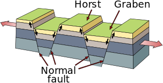
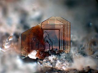
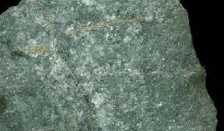
The complex is constructed in the sides of a tectonic horst and includes andesitic structures (Cerro Chingolo) and porphyric dacitic ones like Aguiliri. [3] :5 The centre consists of three dacitic lava domes and a dacitic stock intruded in Tertiary sediments and basement. The complex's composition is dacitic and biotites in the complex are K-Ar dated 12.7 mya ago, of Middle Miocene age. [1] The complex was originally a cryptodome complex that was exposed by erosion. [4] :258
In physical geography and geology, a horst is a raised fault block bounded by normal faults. A horst is a raised block of the Earth's crust that has lifted, or has remained stationary, while the land on either side (graben) has subsided. The word Horst in Dutch and German means heap – cognate with English "hurst".
Tertiary is the former term for the geologic period from 66 million to 2.58 million years ago, a timespan that occurs between the superseded Secondary period and the Quaternary. The Tertiary is no longer recognized as a formal unit by the International Commission on Stratigraphy, but the word is still widely used. The traditional span of the Tertiary has been divided between the Paleogene and Neogene periods and extends to the first stage of the Pleistocene Epoch, the Gelasian stage.
Biotite is a common phyllosilicate mineral within the mica group, with the approximate chemical formula K(Mg,Fe)
3AlSi
3O
10(F,OH)
2. More generally, it refers to the dark mica series, primarily a solid-solution series between the iron-endmember annite, and the magnesium-endmember phlogopite; more aluminous end-members include siderophyllite. Biotite was named by J.F.L. Hausmann in 1847 in honor of the French physicist Jean-Baptiste Biot, who performed early research into the many optical properties of mica.
Plagioclase phenocrysts are contained in the dacite, as well as more derived allanite, biotite, plagioclase, quartz and other minerals. Inclusions of apatite, monazite and zircon are also contained in allanite. [5] Uranium minerals are found associated with iron and manganese oxide, marcasite and pyrite. [3] :5
Plagioclase is a series of tectosilicate (framework silicate) minerals within the feldspar group. Rather than referring to a particular mineral with a specific chemical composition, plagioclase is a continuous solid solution series, more properly known as the plagioclase feldspar series (from the Ancient Greek for "oblique fracture", in reference to its two cleavage angles). This was first shown by the German mineralogist Johann Friedrich Christian Hessel (1796–1872) in 1826. The series ranges from albite to anorthite endmembers (with respective compositions NaAlSi3O8 to CaAl2Si2O8), where sodium and calcium atoms can substitute for each other in the mineral's crystal lattice structure. Plagioclase in hand samples is often identified by its polysynthetic crystal twinning or 'record-groove' effect.
A phenocryst is an early forming, relatively large and usually conspicuous crystal distinctly larger than the grains of the rock groundmass of an igneous rock. Such rocks that have a distinct difference in the size of the crystals are called porphyries, and the adjective porphyritic is used to describe them. Phenocrysts often have euhedral forms, either due to early growth within a magma, or by post-emplacement recrystallization. Normally the term phenocryst is not used unless the crystals are directly observable, which is sometimes stated as greater than .5 millimeter in diameter. Phenocrysts below this level, but still larger than the groundmass crystals, are termed microphenocrysts. Very large phenocrysts are termed megaphenocrysts. Some rocks contain both microphenocrysts and megaphenocrysts. In metamorphic rocks, crystals similar to phenocrysts are called porphyroblasts.
Allanite (also called orthite) is a sorosilicate group of minerals within the broader epidote group that contain a significant amount of rare-earth elements. The mineral occurs mainly in metamorphosed clay-rich sediments and felsic igneous rocks. It has the general formula A2M3Si3O12[OH], where the A sites can contain large cations such as Ca2+, Sr2+, and rare-earth elements, and the M sites admit Al3+, Fe3+, Mn3+, Fe2+, or Mg2+ among others. However, a large amount of additional elements, including Th, U, Zr, P, Ba, Cr and others may be present in the mineral. The International Mineralogical Association lists four minerals in the allanite group, each recognized as a unique mineral: allanite-(Ce), allanite-(La), allanite-(Nd), and allanite-(Y), depending on the dominant rare earth present: cerium, lanthanum, neodymium or yttrium.
The local geology consists of Ordovician marine sediments with local pre-Ordovician outcrops. During the Oligocene-Miocene, the Pehuenche orogeny caused widespread sedimentation in the region, forming the Log Log Formation. Large scale andesitic, dacitic and rhyolitic activity commenced during the Miocene Quechua orogeny, forming the Aguiliri centre. [3] :3–4
The Ordovician is a geologic period and system, the second of six periods of the Paleozoic Era. The Ordovician spans 41.2 million years from the end of the Cambrian Period 485.4 million years ago (Mya) to the start of the Silurian Period 443.8 Mya.
The Oligocene is a geologic epoch of the Paleogene Period and extends from about 33.9 million to 23 million years before the present. As with other older geologic periods, the rock beds that define the epoch are well identified but the exact dates of the start and end of the epoch are slightly uncertain. The name Oligocene was coined in 1854 by the German paleontologist Heinrich Ernst Beyrich; the name comes from the Ancient Greek ὀλίγος and καινός, and refers to the sparsity of extant forms of molluscs. The Oligocene is preceded by the Eocene Epoch and is followed by the Miocene Epoch. The Oligocene is the third and final epoch of the Paleogene Period.
The Miocene is the first geological epoch of the Neogene Period and extends from about 23.03 to 5.333 million years ago (Ma). The Miocene was named by Charles Lyell; its name comes from the Greek words μείων and καινός and means "less recent" because it has 18% fewer modern sea invertebrates than the Pliocene. The Miocene is preceded by the Oligocene and is followed by the Pliocene.
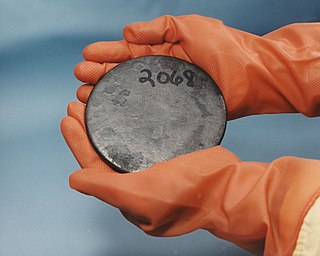
The uranium mineral autunite is found in the country rock surrounding the dome. [6] This mineral was probably formed by volatile activity acting on the dacites. [2] Meta-autunite, meta-orbernite and sabugalite are also found. [3] :5 The complex was drilled 225 metres (738 ft). [7] :84
Uranium is a chemical element with symbol U and atomic number 92. It is a silvery-grey metal in the actinide series of the periodic table. A uranium atom has 92 protons and 92 electrons, of which 6 are valence electrons. Uranium is weakly radioactive because all isotopes of uranium are unstable, with half-lives varying between 159,200 years and 4.5 billion years. The most common isotopes in natural uranium are uranium-238 and uranium-235. Uranium has the highest atomic weight of the primordially occurring elements. Its density is about 70% higher than that of lead, and slightly lower than that of gold or tungsten. It occurs naturally in low concentrations of a few parts per million in soil, rock and water, and is commercially extracted from uranium-bearing minerals such as uraninite.
Autunite (hydrated calcium uranyl phosphate), with formula Ca(UO2)2(PO4)2·10–12H2O, is a yellow-greenish fluorescent phosphate mineral with a hardness of 2–2 1⁄2. Autunite crystallizes in the orthorhombic system and often occurs as tabular square crystals, commonly in small crusts or in fan-like masses. Due to the moderate uranium content of 48.27% it is radioactive and also used as uranium ore. Autunite fluoresces bright green to lime green under UV light. The mineral is also called calco-uranite, but this name is rarely used and effectively outdated.
Dacite is an igneous, volcanic rock. It has an aphanitic to porphyritic texture and is intermediate in composition between andesite and rhyolite. The word dacite comes from Dacia, a province of the Roman Empire which lay between the Danube River and Carpathian Mountains where the rock was first described.
The Almolonga volcano, usually called "Cerro Quemado" is an andesitic stratovolcano in the south-western department of Quetzaltenango in Guatemala. The volcano is located near the town of Almolonga, just south of Quetzaltenango, Guatemala's second largest city.
The Purico complex is a Pleistocene volcanic complex in Chile close to Bolivia, formed by an ignimbrite, several lava domes and stratovolcanoes and one maar. It is one of the Chilean volcanoes of the Andes, and more specifically the Chilean segment of the Central Volcanic Zone, one of the four volcanic belts which make up the Andean Volcanic Belt. The Central Volcanic Zone spans Peru, Bolivia, Chile and Argentina and includes 44 active volcanoes as well as the Altiplano-Puna volcanic complex, a system of large calderas and ignimbrites of which Purico is a member of. Licancabur to the north, La Pacana southeast and Guayaques to the east are separate volcanic systems.
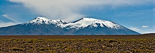
Cerros de Tocorpuri is a volcanic complex located along the border between Bolivia and Chile.
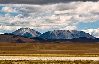
Cerro del León is a stratovolcano located in El Loa province, Antofagasta Region, Chile. It is part of the Chilean Central Volcanic Zone and forms a volcanic lineament with neighbouring Paniri and Toconce that was active into the Holocene. Cerro del León itself was constructed in three stages by andesitic–dacitic lava flows and was subject to glacial erosion.
Casa Colorada is a dacitic volcanic dome complex erupted 17 million years ago. It has a volume of 1.5 cubic kilometres (0.36 cu mi). The complex formed in three stages, involving a tuff ring, lava domes and dacitic lava flows. It is constructed on red beds and a basement of Ordovician age. The main dome is dated 17.3 mya by potassium–argon dating. The main minerals are biotite, hornblende, feldspar and quartz; oxide minerals are also present.
Cerro Chao is a lava flow complex associated with the Cerro del León volcano in the Andes. It is the largest known Quaternary silicic volcano body and part of the most recent phase of activity in the Altiplano–Puna volcanic complex.
Cerro Bonete is a volcano in Sur Lipez. It is part of the Cordillera de Lipez and is 5,630 metres (18,470 ft) high. The volcano is of Miocene age and formed by potassium-rich felsic rocks. It is associated with the 15 mya South Lípez ignimbrites.
Cerro Guacha is a Miocene caldera in southwestern Bolivia's Sur Lípez Province. Part of the volcanic system of the Andes, it is considered to be part of the Central Volcanic Zone (CVZ), one of the three volcanic arcs of the Andes, and its associated Altiplano-Puna volcanic complex (APVC). A number of volcanic calderas occur within the latter.
Cerro Chanka is a Pleistocene lava dome in the Andes. It is part of the Altiplano-Puna volcanic complex. Potassium-argon dating indicates that the dome last erupted 119.8±5.4 ka ago. Another reported age is 1.5±0.1 mya.
Cerro Chascon-Runtu Jarita is a complex of lava domes located inside, but probably unrelated to, the Pastos Grandes caldera. It is part of the more recent phase of activity of the Altiplano-Puna volcanic complex.
Panizos is a Late Miocene era caldera in the Santa Cruz department of Bolivia and the Jujuy Province of Argentina. It is part of the Altiplano-Puna volcanic complex of the Central Volcanic Zone in the Andes. 50 volcanoes active in recent times are found in the Central Volcanic Zone, and several major caldera complexes are situated in the area. The caldera is located in a logistically difficult area of the Andes.
Chinchillas is a lava dome complex in the northern Puna of the Andes, in the Sierra de Rinconada. The complex is constructed on an Ordovician basement called the Acoite Formation. In addition to the dacitic lava dome on the southern end of the complex it also contains small volume massive pyroclastic flows and ash-and-block flows. The complex has a volume of 0.26 cubic kilometres (0.062 cu mi). The complex was formed 13±1 mya over a fault zone. Hydrothermal Ag-Pb-Zn deposits found there in breccia were mined occasionally. According to Coira et al. (1996) it, Cerro Redondo and Pan de Azúcar may be part of a caldera system in the Pozuelos basin.
Nevados de Pastos Grandes is a Miocene volcanic centre in the Puna, Salta province, Argentina. It is a volcanic complex with several centres named El Queva, Gordo and Azufre. Some minor Pleistocene glaciation has affected the volcanic complex.
Kari-Kari is a Miocene caldera in the Potosi department, Bolivia. It is part of the El Fraile ignimbrite field of the Central Volcanic Zone of the Andes. Volcanic activity in the Central Volcanic Zone has generated 44 volcanic centres with postglacial activity and a number of calderas, including the Altiplano-Puna volcanic complex.
Cerro Bitiche is a volcanic field in Argentina. It is located east of the Central Volcanic Zone away from the volcanic arc within the Altiplano-Puna volcanic complex (APVC), close to Zapaleri volcano.
Minuyoc is a lava dome complex in the Andes.
Pairique volcanic complex is a volcanic complex in the Jujuy Province, Argentina.
Apacheta-Aguilucho volcanic complex is a volcanic complex in Chile. It consists of two volcanoes Cerro Apacheta and Cerro Aguilucho, which are constructed mainly by lava flows and surrounded by outcrops of lava. A sector collapse and its landslide deposit are located on Apacheta's eastern flank. Two lava domes are associated with the volcanic complex, Chac-Inca and Pabellón.
Los Frailes is an ignimbrite plateau in Bolivia, between the city of Potosi and the Lake Poopo. It belongs to a group of ignimbrites that exist in the Central Andes and which includes the Altiplano–Puna volcanic complex. The plateau covers a surface of 7,500 square kilometres (2,900 sq mi)–8,500 square kilometres (3,300 sq mi) with about 2,000 cubic kilometres (480 cu mi) of ignimbrite.
This article about mining is a stub. You can help Wikipedia by expanding it. |
This volcanology article is a stub. You can help Wikipedia by expanding it. |