Ahaus

Last updated • 2 min readFrom Wikipedia, The Free Encyclopedia
Ahaus
Ahaus Georgsbrunnen.jpg
St George's Fountain in Ahaus
DEU Ahaus COA.svg
Location of Ahaus within Borken district
Ahaus in BOR.svgHeidenBocholtBorkenHeekGronau
Germany adm location map.svg
Red pog.svg
Ahaus
North Rhine-Westphalia location map 01.svg
Red pog.svg
Ahaus
Coordinates: 52°4′N7°0′E / 52.067°N 7.000°E / 52.067; 7.000
Country Germany
State North Rhine-Westphalia
Admin. region Münster
District Borken
Subdivisions6
Government
   Mayor (202025) Karola Voß [1] (Ind.)
Area
  Total151.22 km2 (58.39 sq mi)
Highest elevation
70 m (230 ft)
Lowest elevation
36 m (118 ft)
Population
 (2023-12-31) [2]
  Total40,580
  Density270/km2 (700/sq mi)
Time zone UTC+01:00 (CET)
  Summer (DST) UTC+02:00 (CEST)
Postal codes
48683
Dialling codes 02561, 02567
Vehicle registration BOR, AH, BOH
Website www.ahaus.de

Ahaus (German pronunciation: [ˈaːhaʊs] ; Westphalian: Ausen) is a town in the district of Borken in the state of North Rhine-Westphalia, Germany. It is located near the border with the Netherlands, lying some 20 km south-east of Enschede and 15 km south from Gronau. Ahaus is the location of one of Germany's interim storage facilities for radioactive spent fuel. [3]

Contents

History

The first written mention of the aristocratic seat of Haus an der Aa dates from around 1030. Around 1120, Bernhard von Diepenheim had Ahaus Castle built where Ahaus Castle stands today. In 1154 his son Lifhard called himself von Ahaus for the first time. [4]  The lords of Ahaus belonged to the smaller noble dynasties in Westphalia in the wider environment of the Munster bishops. They got into a fight with them in 1176 when the nobleman Johann von Ahaus gave his castle as a fief to the Archbishop of Cologne. In 1177, however, John had to surrender to Prince Bishop Hermann II of Munstersubdue. The castles of Ahaus and Diepenheim, which belonged to the noble lords of Ahaus, were destroyed. Nevertheless, the noble lords remained in possession of their rule. [5]

In 1389 the noble lords of Ahaus granted the castle settlement an excise privilege. Two years later, Ahaus received city rights. In 1406, the Prince-Bishop of Munster, Otto IV von Hoya, bought the lordship of Ahaus and incorporated it into the Bishopric of Munster. [4] It was combined by the Bishopric of Münster together with 24 parishes, which extended over large parts of West Münsterland, to form the Amt of Ahaus . It lasted until it was dissolved by the Reichsdeputationshauptschluss in 1803.

Climate

Ahaus has an oceanic climate (Köppen: Cfb; Trewartha: Dobk).

Climate data for Ahaus, 1991–2020 normals, extremes 2006–present
MonthJanFebMarAprMayJunJulAugSepOctNovDecYear
Record high °C (°F)16.1
(61.0)
19.3
(66.7)
24.5
(76.1)
28.5
(83.3)
32.3
(90.1)
35.9
(96.6)
39.5
(103.1)
36.6
(97.9)
32.2
(90.0)
28.0
(82.4)
19.8
(67.6)
16.5
(61.7)
39.5
(103.1)
Mean maximum °C (°F)11.7
(53.1)
12.4
(54.3)
17.7
(63.9)
23.9
(75.0)
27.1
(80.8)
30.9
(87.6)
33.3
(91.9)
31.4
(88.5)
27.3
(81.1)
22.1
(71.8)
16.3
(61.3)
12.6
(54.7)
34.9
(94.8)
Mean daily maximum °C (°F)5.4
(41.7)
6.5
(43.7)
10.0
(50.0)
15.4
(59.7)
18.8
(65.8)
21.9
(71.4)
24.0
(75.2)
23.0
(73.4)
19.5
(67.1)
14.7
(58.5)
9.6
(49.3)
6.3
(43.3)
14.6
(58.3)
Daily mean °C (°F)3.1
(37.6)
3.5
(38.3)
5.8
(42.4)
10.1
(50.2)
13.7
(56.7)
16.8
(62.2)
18.6
(65.5)
17.7
(63.9)
14.5
(58.1)
10.9
(51.6)
6.9
(44.4)
4.2
(39.6)
10.5
(50.9)
Mean daily minimum °C (°F)0.6
(33.1)
0.5
(32.9)
1.7
(35.1)
4.3
(39.7)
8.0
(46.4)
11.2
(52.2)
12.8
(55.0)
12.3
(54.1)
9.5
(49.1)
7.1
(44.8)
3.9
(39.0)
1.7
(35.1)
6.1
(43.0)
Mean minimum °C (°F)−7.3
(18.9)
−5.5
(22.1)
−4.3
(24.3)
−2.2
(28.0)
1.1
(34.0)
5.8
(42.4)
6.9
(44.4)
7.0
(44.6)
3.8
(38.8)
0.6
(33.1)
−2.9
(26.8)
−5.3
(22.5)
−9.4
(15.1)
Record low °C (°F)−17.1
(1.2)
−16.0
(3.2)
−9.1
(15.6)
−5.7
(21.7)
−1.0
(30.2)
3.4
(38.1)
4.9
(40.8)
5.0
(41.0)
0.7
(33.3)
−4.0
(24.8)
−7.2
(19.0)
−14.3
(6.3)
−17.1
(1.2)
Average precipitation mm (inches)76.2
(3.00)
56.7
(2.23)
57.6
(2.27)
29.7
(1.17)
49.6
(1.95)
64.1
(2.52)
75.8
(2.98)
97.5
(3.84)
58.9
(2.32)
65.1
(2.56)
65.5
(2.58)
78.1
(3.07)
774.9
(30.51)
Average extreme snow depth cm (inches)3.5
(1.4)
1.2
(0.5)
0.1
(0.0)
0
(0)
0
(0)
0
(0)
0
(0)
0
(0)
0
(0)
0
(0)
0.3
(0.1)
2.9
(1.1)
4.7
(1.9)
Average precipitation days (≥ 0.1 mm)19.815.915.911.913.413.715.817.413.315.718.120.7191.8
Average relative humidity (%)87.883.878.070.770.072.673.377.181.485.388.389.179.8
Mean monthly sunshine hours 43.870.4128.6191.0207.1202.9218.2188.5147.8100.756.440.81,596.3
Source: Deutscher Wetterdienst/SKlima.de [6]

Twin towns – sister cities

Ahaus is twinned with: [7]

Notable people

See also

Related Research Articles

<span class="mw-page-title-main">Münster</span> City in North Rhine-Westphalia, Germany

Münster is an independent city in North Rhine-Westphalia, Germany. It is in the northern part of the state and is considered to be the cultural centre of the Westphalia region. It is also a state district capital. Münster was the location of the Anabaptist rebellion during the Protestant Reformation and the site of the signing of the Treaty of Westphalia ending the Thirty Years' War in 1648. Today, it is known as the bicycle capital of Germany.

Borken is a Kreis (district) in the northwestern part of North Rhine-Westphalia, Germany in the Münster region. Neighboring districts are Steinfurt, Coesfeld, Recklinghausen, Wesel, Cleves, Bentheim in the Lower Saxony and the Dutch provinces Gelderland and Overijssel. The two biggest cities are Bocholt and Gronau.

<span class="mw-page-title-main">Wesel</span> Town in North Rhine-Westphalia, Germany

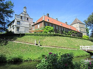
Wesel is a city in North Rhine-Westphalia, Germany. It is the capital of the Wesel district.

<span class="mw-page-title-main">Barntrup</span> Town in North Rhine-Westphalia, Germany

Barntrup is a town in the Lippe district of North Rhine-Westphalia, Germany. It has an area of 59.46 km2 and 8,501 inhabitants (2019). It lies 40 km east from Bielefeld and 9 km west from Bad Pyrmont at the east border of NRW to Lower Saxony.

<span class="mw-page-title-main">Coesfeld</span> Town in North Rhine-Westphalia, Germany

Coesfeld is the capital of the district of Coesfeld in the German state of North Rhine-Westphalia.

<span class="mw-page-title-main">Dülmen</span> Place in North Rhine-Westphalia, Germany

Dülmen is a town in the district of Coesfeld, North Rhine-Westphalia, Germany.

<span class="mw-page-title-main">Zülpich</span> Place in North Rhine-Westphalia, Germany

Zülpich is a town in North Rhine-Westphalia, Germany between Aachen and Bonn. It belongs to the district of Euskirchen.

<span class="mw-page-title-main">Werne</span> Town in North Rhine-Westphalia, Germany

Werne an der Lippe is a town in the Federal state of North Rhine-Westphalia in the Unna district in Germany. It is located on the southern edge of the Münsterland region near the Ruhrgebiet. The population of Werne is about 32,000.

<span class="mw-page-title-main">Kaarst</span> Town in North Rhine-Westphalia, Germany

Kaarst is a town in Germany. It lies in the district of Rhein-Kreis Neuss in North Rhine-Westphalia. It is 5 km west of Neuss and 12 km east of Mönchengladbach.

<span class="mw-page-title-main">Olfen</span> Town in North Rhine-Westphalia, Germany

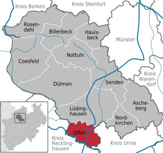
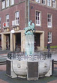
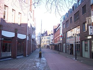
Olfen is a town in the district of Coesfeld, in North Rhine-Westphalia, Germany.

<span class="mw-page-title-main">Vreden</span> Town in North Rhine-Westphalia, Germany

Vreden is a small town in North Rhine-Westphalia, Germany near the Dutch border. The town is located near the river Berkel. The first mentioning of the town is proven for the year 839. In 1252 Vreden obtained city rights.

<span class="mw-page-title-main">Bad Driburg</span> Town in North Rhine-Westphalia, Germany

Bad Driburg is a town and spa in Höxter district in North Rhine-Westphalia, Germany, situated on the river Aa and the Altenbeken–Kreiensen railway.

<span class="mw-page-title-main">Kranenburg, North Rhine-Westphalia</span> Municipality in North Rhine-Westphalia, Germany

Kranenburg is a municipality in the district of Cleves in the state of North Rhine-Westphalia, Germany. It is located near the border with the Netherlands, 12 kilometres (7 mi) south-east of Nijmegen and 11 kilometres (7 mi) west of Cleves.

<span class="mw-page-title-main">Rheda-Wiedenbrück</span> Town in North Rhine-Westphalia, Germany

Rheda-Wiedenbrück is a city in the district of Gütersloh, in North Rhine-Westphalia, Germany.

<span class="mw-page-title-main">Ibbenbüren</span> Town in North Rhine-Westphalia, Germany

Ibbenbüren is a town in the district of Steinfurt, in North Rhine-Westphalia, Germany.

<span class="mw-page-title-main">Neukirchen-Vluyn</span> Town in North Rhine-Westphalia, Germany

Neukirchen-Vluyn is a town in the district of Wesel, in North Rhine-Westphalia, Germany. It is situated approximately 5 km west of Moers, and 15 km north of Krefeld.

<span class="mw-page-title-main">Nordkirchen Castle</span> Palace in North Rhine Westphalia, Germany

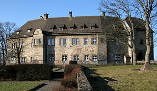
Schloss Nordkirchen is a palace situated in the town of Nordkirchen in the Coesfeld administrative district in the state of North Rhine Westphalia, Germany. The schloss was largely built between 1703 and 1734 and is known as the "Versailles of Westphalia" since it is the largest of the fully or partly moated Wasserschlösser in that region. It was originally one of the residences of the Prince-Bishopric of Münster.

<span class="mw-page-title-main">Merveldt family</span>

The House of Merveldt is the name of an ancient Westphalian aristocratic family, which belongs to the German nobility of the Middle Ages. The Herrn (Lords) von Merveldt were among the oldest families in the Münsterland. Merfeld, the eponymous seat of the family, is now a neighborhood of the city of Dülmen in the District of Coesfeld in the state of North Rhine-Westphalia in Germany.

The County of Diepholz, that was first known as the Lordship of Diepholz, was a territory in the Holy Roman Empire in the Lower-Rhenish-Westphalian Circle. It was ruled by the Noble Lords, later Counts, of Diepholz from the late tenth century until 1585, when it was mostly incorporated into the Duchy of Brunswick-Lüneburg.

<span class="mw-page-title-main">County of Steinfurt</span>

The County of Steinfurt, originally the Lordship of Steinfurt, was a historic territory of the Holy Roman Empire in the Munsterland. It existed from roughly 1100 until 1806.

References

  1. Wahlergebnisse in NRW Kommunalwahlen 2020, Land Nordrhein-Westfalen, accessed 19 June 2021.
  2. "Bevölkerung der Gemeinden Nordrhein-Westfalens am 31. Dezember 2023 – Fortschreibung des Bevölkerungsstandes auf Basis des Zensus vom 9. Mai 2011" (in German). Landesbetrieb Information und Technik NRW . Retrieved 2024-06-20.
  3. Interim Storage of Spent Fuel in Germany History, State and Prospects, Bundesamt für Strahlenschutz, June 2015.
  4. 1 2 "www.ahaus.de: Geschichte". 2016-01-19. Archived from the original on 2016-01-19. Retrieved 2023-07-12.{{cite web}}: CS1 maint: bot: original URL status unknown (link)
  5. "Internet-Portal 'Westfälische Geschichte'". www.lwl.org (in German). 2014-03-25. Retrieved 2023-07-12.
  6. "Monatsauswertung". sklima.de (in German). SKlima. Retrieved 25 October 2024.
  7. "Städtepartnerschaften". stadt-ahaus.de (in German). Ahaus. Archived from the original on 2021-11-25. Retrieved 2021-02-04.