
The Yakima River is a tributary of the Columbia River in south central and eastern Washington state, named for the indigenous Yakama people. The length of the river from headwaters to mouth is 214 miles (344 km), with an average drop of 9.85 feet per mile (1.866 m/km). It is the longest river entirely in Washington state.

Yakima is a city in and the county seat of Yakima County, Washington, and the state's eleventh-largest city by population. As of the 2020 census, the city had a total population of 96,968 and a metropolitan population of 256,728. The unincorporated suburban areas of West Valley and Terrace Heights are considered a part of greater Yakima.

Toppenish is a city in Yakima County, Washington, United States. As of the 2010 census, the city population was 8,949. It is located within the Yakama Indian Reservation, established in 1855.

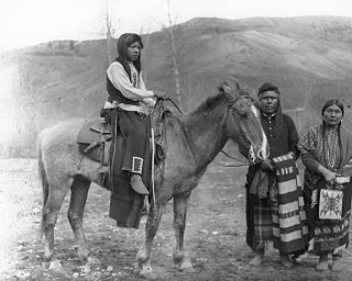
The Yakama are a Native American tribe with nearly 10,851 members, based primarily in eastern Washington state.
The Yakama Indian Reservation is a Native American reservation in Washington state of the federally recognized tribe known as the Confederated Tribes and Bands of the Yakama Nation. The tribe is made up of Klikitat, Palus, Wallawalla, Wanapam, Wenatchi, Wishram, and Yakama peoples.

Gifford Pinchot National Forest is a National Forest located in southern Washington, USA, managed by the United States Forest Service. With an area of 1.32 million acres (5300 km2), it extends 116 km along the western slopes of Cascade Range from Mount Rainier National Park to the Columbia River. The forest straddles the crest of the South Cascades of Washington State, spread out over broad, old growth forests, high mountain meadows, several glaciers, and numerous volcanic peaks. The forest's highest point is at 12,276 ft. at the top of Mount Adams, the second tallest volcano in the state after Rainier. Often found abbreviated GPNF on maps and in texts, it includes the 110,000-acre (450 km2) Mount St. Helens National Volcanic Monument, established by Congress in 1982.
The Palouse are a Sahaptin tribe recognized in the Treaty of 1855 with the United States along with the Yakama. It was negotiated at the 1855 Walla Walla Council. A variant spelling is Palus. Today they are enrolled in the federally recognized Confederated Tribes and Bands of the Yakama Nation and some are also represented by the Colville Confederated Tribes.

The Yakima War (1855-1858) was a conflict between the United States and the Yakama, a Sahaptian-speaking people of the Northwest Plateau, then part of Washington Territory, and the tribal allies of each. It primarily took place in the southern interior of present-day Washington. Isolated battles in western Washington and the northern Inland Empire were sometimes separately referred to as the Puget Sound War and the Palouse War, respectively. This conflict is also referred to as the Yakima Native American War of 1855.
Sahaptin or Shahaptin, endonym Ichishkin, is one of the two-language Sahaptian branch of the Plateau Penutian family spoken in a section of the northwestern plateau along the Columbia River and its tributaries in southern Washington, northern Oregon, and southwestern Idaho, in the United States; the other language is Nez Perce or Niimi'ipuutímt. Many of the tribes that surrounded the land were skilled with horses and trading with one another; some tribes were known for their horse breeding which resulted in today's Appaloosa or Cayuse horse.
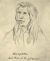
Kamiakin (1800–1877) (Yakama) was a leader of the Yakama, Palouse, and Klickitat peoples east of the Cascade Mountains in what is now southeastern Washington state. In 1855, he was disturbed by threats of the Territorial Governor, Isaac Stevens, against the tribes of the Columbia Plateau. After being forced to sign a treaty of land cessions, Kamiakin organized alliances with 14 other tribes and leaders, and led the Yakima War of 1855–1858.
The Touchet River is a 55-mile (89 km) tributary of the Walla Walla River in southeastern Washington in the United States. The Touchet River drains an area of about 740 square miles (1,900 km2) in Columbia County and Walla Walla County.
The Wenatchi people or Šnp̍əšqʷáw̉šəxʷi / Np̓əšqʷáw̓səxʷ are a group of Native Americans who originally lived in the region near the confluence of the Columbia and Wenatchee Rivers in Eastern Washington state. They spoke Interior Salish and ate salmon, starchy roots like camas and biscuitroot, berries, deer, sheep and whatever else they could hunt or catch. The river that they lived on, the Wenatchee River, had one of the greatest runs of salmon in the world prior to numerous hydroelectric dams being put in on the downstream Columbia, pollution and other issues, and was their main food source.

The Horse Heaven Hills are a long range of high, rolling hills in Klickitat, Yakima, and Benton counties in Washington. The hills are an anticline ridge in the Yakima Fold Belt formed by north–south compression of lava flows in the Columbia River Basalt Group. The highest point is Bickleton Ridge in the west end of the hills. They lie within the rain shadow to the east of the Cascade Range, making them significantly drier and hotter than regions west of the Cascades.

The Battle of Pine Creek, also known as the Battle of Tohotonimme and the Steptoe Disaster, was a conflict between United States Army forces under Brevet Lieutenant Colonel Edward Steptoe and members of the Coeur d'Alene, Palouse and Spokane Native American tribes. It took place on May 17, 1858, near what is present-day Rosalia, Washington. The Native Americans were victorious.

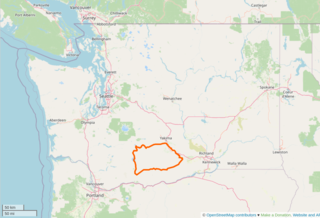
Ahtanum Ridge is a long anticline mountain ridge in Yakima County in the U.S. state of Washington. It is located just south of the city of Yakima, and much of its length is at the northern edge of the Yakama Indian Reservation.
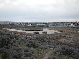
Tampico is a census-designated place and unincorporated community in Yakima County, Washington, United States, located approximately eighteen miles west of Yakima on Ahtanum Creek. The population was 312 at the 2010 United States Census.
Amon Creek is the largest tributary of the Lower Yakima River in Benton County, Washington. From the source of its East Fork to its mouth at the Yakima, it flows about 13 miles (21 km), passing through Kennewick and Richland. The East Fork as well as the main course north of where both forks come together flow south to north. The West Fork starts in Badger Canyon by heading south, but slowly wraps around along with the topography of the canyon to flow out of it northbound. There is an easily visible riparian zone along most of the length of the main course, along with the West Fork up Badger Canyon and the East Fork until I-82.

St. Joseph's Mission is a mission that was established in Oregon Territory, United States (US) by Jesuit priests in 1852. The mission is located near Tampico, Washington and was listed on the National Register of Historic Places in 1976.

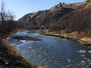
Kamiakin's Gardens were the first place to be irrigated in the Yakima River valley in central Washington state. Chief Kamiakin (1800–1877) was a leader of the Yakama Nation who sought to avoid conflict with European settlers and missionaries who started arriving in the region in the 1840s. Kamiakin directed that a ditch be excavated to nourish a plot near Ahtanum Creek, hoping to provide a sedentary existence for his people that would keep them out of conflict with the settlers. Crops included squash, corn and potatoes, fed by what became known to settlers as Kamiakin's Ditch. In 1851 a Catholic mission was established near the creek.
Jean-Charles-Jean-Baptiste-Félix Pandosy, commonly known as Father Pandosy, was a French Catholic priest who was the first settler in the Kelowna area in British Columbia. He set up a church and a school and attracted many settlers to the area. He founded the Okanagan Mission which was the first permanent white settlement in the British Columbia Interior aside from the forts for the Hudson's Bay Company and the gold rush boomtowns of the Fraser Canyon.


