You can help expand this article with text translated from the corresponding article in German. (October 2021)Click [show] for important translation instructions.
|
Ainaro | |
|---|---|
| |
 Monument to Dom Aleixo in Ainaro | |
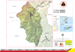 Official map | |
 Ainaro | |
| Coordinates: 8°59′S125°30′E / 8.983°S 125.500°E | |
| Country | |
| Municipality | Ainaro |
| Seat | Ainaro |
| Sucos |
|
| Area | |
• Total | 234.7 km2 (90.6 sq mi) |
| Population (2015 census) | |
• Total | 16,121 |
| • Density | 68.69/km2 (177.9/sq mi) |
| Households (2015 census) | |
| • Total | 2,755 |
| Time zone | UTC+09:00 (TLT) |
Ainaro, officially Ainaro Administrative Post (Portuguese : Posto Administrativo de Ainaro, Tetum : Postu administrativu Ainaru), is an administrative post (and was formerly a subdistrict) in Ainaro municipality, Timor-Leste. [1] [2] Its seat or administrative centre is the suco of Ainaro. [2]
The administrative post has a population of approximately 14,130 people (2001). [3] It contains the small mountain town of Ainaro, which is also the capital of the municipality, along with the sucos of Ainaro, Soro, Maununo, Cassa, Suro Craic, Manutassi, and Mau-Ulo.