Bobonaro | |
|---|---|
| |
 | |
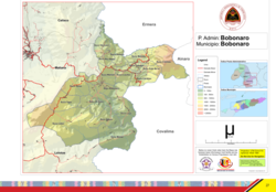 Official map | |
 Bobonaro | |
| Coordinates: 9°2′S125°20′E / 9.033°S 125.333°E | |
| Country | |
| Municipality | Bobonaro |
| Seat | Bobonaro |
| Sucos | |
| Area | |
• Total | 212.5 km2 (82.0 sq mi) |
| Population (2015 census) | |
• Total | 24,719 |
| • Density | 116.3/km2 (301.3/sq mi) |
| Households (2015 census) | |
| • Total | 4,467 |
| Time zone | UTC+09:00 (TLT) |
Bobonaro, officially Bobonaro Administrative Post (Portuguese : Posto Administrativo de Bobonaro, Tetum : Postu administrativu Bobonaru), is an administrative post (and was formerly a subdistrict) in Bobonaro municipality, Timor-Leste. [1] [2] Its seat or administrative centre is Bobonaro, [3] [2] and its population at the 2010 census was 23,108. [4]