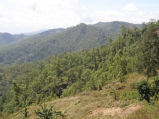
Quelicai, officially Quelicai Administrative Post, is an administrative post in Baucau municipality, East Timor. Its seat or administrative centre is Lacoliu.
Laulara, officially Laulara Administrative Post, is an administrative post in Aileu municipality, East Timor. Its seat or administrative centre is Madabeno.

Remexio, officially Remexio Administrative Post, is an administrative post in Aileu municipality, East Timor. Its seat or administrative centre is Acumau.

Vemasse, officially Vemasse Administrative Post, is an administrative post in Baucau municipality, East Timor. Its seat or administrative centre is Vemasse.
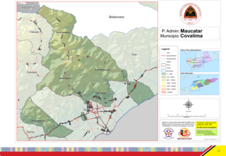
Maucatar, officially Maucatar Administrative Post, is an administrative post in Cova Lima municipality, East Timor. Its seat or administrative centre is Ogues, and its population at the 2004 census was 5,876.

Cristo Rei, officially Cristo Rei Administrative Post, is an administrative post in Dili municipality, East Timor. Its seat or administrative centre is Becora, and its population at the 2010 census was 54,936.
Nain Feto, officially Nain Feto Administrative Post, is an administrative post in Dili municipality, East Timor. Its seat or administrative centre is Gricenfor, and its population at the 2004 census was 18,693.

Vera Cruz, officially Vera Cruz Administrative Post, is an administrative post in Dili municipality, East Timor. Its seat or administrative centre is Mascarenhas, and its population at the 2004 census was 28,178.

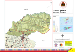
Hatulia, officially Hatulia Administrative Post, is an administrative post in Ermera municipality, East Timor. Its seat or administrative centre is Hatolia Vila, and its population was 30,659 in the 2004 census.

Lacluta, officially Lacluta Administrative Post, is an administrative post in Viqueque municipality, East Timor. Its seat or administrative centre is Dilor.

Uatucarbau, officially Uatucarbau Administrative Post, is an administrative post in Viqueque municipality, East Timor. Its seat or administrative centre is Irabin de Baixo.

Manatuto, officially Manatuto Administrative Post, is an administrative post in Manatuto municipality, East Timor. Its seat or administrative centre is the suco of Sau.

Maubara, officially Maubara Administrative Post, is an administrative post in Liquiçá municipality, East Timor, just west of the city of Liquiçá. Its seat or administrative centre is Vaviquinia.

Baucau, officially Baucau Administrative Post, is an administrative post in Baucau municipality, East Timor. Its seat or administrative centre is Bahú.

Lospalos, officially Lospalos Administrative Post, is an administrative post in Lautém municipality, East Timor. Its seat or administrative centre is Fuiloro.

Liquiçá, officially Liquiçá Administrative Post, is an administrative post in Liquiçá municipality, East Timor. Its seat or administrative centre is Dato.
Bazartete, officially Bazartete Administrative Post, is an administrative post in Liquiçá municipality, East Timor. Its seat or administrative centre is Fatumasi.

Same, officially Same Administrative Post, is an administrative post in the Manufahi municipality of East Timor. Its seat or administrative centre is Holarua.
Fatuberlio, officially Fatuberlio Administrative Post, is an administrative post in the Manufahi municipality of East Timor. Its seat or administrative centre is Clacuc.

Nitibe, officially Nitibe Administrative Post, is an administrative post in the Oecusse municipality and Special Administrative Region (SAR) of East Timor. Its seat or administrative centre is Beneufe.