Air traffic control (ATC) is a service provided by ground-based air traffic controllers who direct aircraft on the ground and through a given section of controlled airspace, and can provide advisory services to aircraft in non-controlled airspace. The primary purpose of ATC worldwide is to prevent collisions, organize and expedite the flow of air traffic, and provide information and other support for pilots. In some countries, ATC plays a security or defensive role, or is operated by the military.

Norfolk International Airport is seven miles (11 km) northeast of downtown Norfolk, an independent city in Virginia, United States. It is owned and operated by the Norfolk Airport Authority: a bureau under the municipal government. The airport serves the Hampton Roads metropolitan area of southeast Virginia as well as northeast North Carolina. Despite its name, the airport does not have any international destinations.
Adak Airport is a state-owned public-use airport located west of Adak, on Adak Island in the Aleutian Islands in the U.S. state of Alaska. The airport is the farthest western airfield with scheduled passenger air service in the entire United States at 176.64W.
Airport Surface Detection Equipment, Model X, or ASDE-X, is a runway-safety tool that enables air traffic controllers to detect potential runway conflicts by providing detailed coverage of movement on runways and taxiways. By collecting data from a variety of sources, ASDE-X is able to track vehicles and aircraft on airport surfaces and obtain identification information from aircraft transponders.

Lake Hood Seaplane Base is a state-owned seaplane base located three nautical miles (6 km) southwest of the central business district of Anchorage in the U.S. state of Alaska. The Lake Hood Strip is a gravel runway located adjacent to the seaplane base. The gravel strip airport's previous code of has been decommissioned and combined with as another landing surface.

An airport surveillance radar (ASR) is a radar system used at airports to detect and display the presence and position of aircraft in the terminal area, the airspace around airports. It is the main air traffic control system for the airspace around airports. At large airports it typically controls traffic within a radius of 60 miles (96 km) of the airport below an elevation of 25,000 feet. The sophisticated systems at large airports consist of two different radar systems, the primary and secondary surveillance radar. The primary radar typically consists of a large rotating parabolic antenna dish that sweeps a vertical fan-shaped beam of microwaves around the airspace surrounding the airport. It detects the position and range of aircraft by microwaves reflected back to the antenna from the aircraft's surface. The secondary surveillance radar consists of a second rotating antenna, often mounted on the primary antenna, which interrogates the transponders of aircraft, which transmits a radio signal back containing the aircraft's identification, barometric altitude, and an emergency status code, which is displayed on the radar screen next to the return from the primary radar.

Wainwright Airport is a public use airport located in Wainwright, a city in the North Slope Borough of the U.S. state of Alaska. The airport is owned by the North Slope Borough.

Tom Madsen Airport is a state-owned public-use airport in City of Unalaska, on Amaknak Island in the Aleutian Islands, off the coast of the U.S. state of Alaska. It is located near the Bering Sea coast of Unalaska Island, 800 miles (1,300 km) southwest of Anchorage and 1,950 miles (3,140 km) from Seattle.
Saab Sensis Corporation is a technology company based in East Syracuse, New York and is a subsidiary of Saab Group. Saab Sensis, formerly Sensis Corporation, was acquired by Saab Group in 2011. Following the acquisition, Saab consolidated its U.S. defense businesses under a new U.S.-based company named Saab Defense and Security USA (SDAS) leaving Saab Sensis to focus on air traffic solutions. Today, Saab Sensis leads Saab's global Air Traffic Management business with primary offices in Australia, the Netherlands, Sweden, and the U.S.
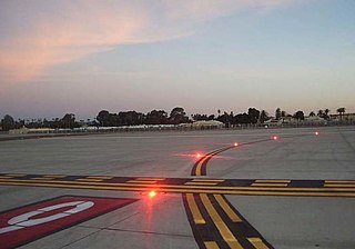
Runway Status Lights (RWSL) are a visual alerting system installed in some airport taxiways and runways for the purpose of collision-avoidance. When illuminated, red high-intensity LEDs indicate the presence of another vehicle either departing, occupying, or landing on an active runway. RWSL systems are fully-automated and intended to alert aircrews and ground vehicle operators of a potential runway incursion hazard. They operate as an additional layer of safety, independent of human-issued air traffic control clearances.

A runway incursion is an aviation incident involving improper positioning of vehicles or people on any airport runway or its protected area. When an incursion involves an active runway being used by arriving or departing aircraft, the potential for a collision hazard or Instrument Landing System (ILS) interference can exist. At present, various runway safety technologies and processes are commonly employed to reduce the risk and potential consequences of such an event.
The Capstone Program was a United States government-funded aviation safety program for the state of Alaska, primarily focusing on rural areas of the state. This joint effort – between the Federal Aviation Administration (FAA), the Alaska Pilot's Association, commercial operators, the University of Alaska, MITRE Corporation, some avionics manufacturers and individual pilots – cut the accident rate in the eastern part of Alaska by around 40%.
The Airport Movement Area Safety System (AMASS) visually and aurally prompts tower controllers to respond to situations which potentially compromise safety. AMASS is an add-on enhancement to the host Airport Surface Detection Equipment Model 3 (ASDE-3) radar that provides automated aural alerts to potential runway incursions and other hazards. AMASS extends the capability of the ASDE-3 and enhances surface movement safety.
The Next Generation Air Transportation System (NextGen) is an unsuccessful modernization project of the United States National Airspace System (NAS). The U.S. Federal Aviation Administration (FAA) began work on NextGen improvements in 2007 and plans to have all major components in place by 2025. The goals of the modernization include using new technologies and procedures to increase the safety, efficiency, capacity, access, flexibility, predictability, and resilience of the NAS while reducing the environmental impact of aviation.
AirNav Systems is a Tampa-based global flight tracking and data services company founded in 2001. The company operates a flight tracking website and mobile app called Radarbox which offers worldwide tracking of commercial and general aviation flights. AirNav Systems also owns and operates a ground-based ADS-B tracking network that is supported by over 20,000 active volunteer ADS-B data feeders from over 180 countries. The company's real-time tracking and data services are also used by 25,000 aviation related businesses, government agencies, airlines, media channels and airports in over 60 countries.

Automatic Dependent Surveillance–Broadcast (ADS-B) is a surveillance technology in which an aircraft determines its position via satellite navigation or other sensors and periodically broadcasts it, enabling it to be tracked. The information can be received by air traffic control ground stations as a replacement for secondary surveillance radar, as no interrogation signal is needed from the ground. It can also be received by other aircraft to provide situational awareness and allow self-separation. ADS-B is "automatic" in that it requires no pilot or external input. It is "dependent" in that it depends on data from the aircraft's navigation system.
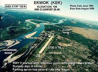
Ekwok Airport is a state-owned public-use airport serving Ekwok, a city in the Dillingham Census Area of the U.S. state of Alaska. Scheduled airline service to Merrill Field in Anchorage, AK is provided by Dena'ina air.

Anchorage Air Route Traffic Control Center (PAZA/ZAN) is located just outside the main gate of Joint Base Elmendorf-Richardson at 700 North Boniface Parkway in Anchorage, Alaska, United States. The Anchorage ARTCC is one of 22 Air Route Traffic Control Centers in the United States.

On July 7, 2017, an Airbus A320-211 operating as Air Canada Flight 759 was nearly involved in an accident at San Francisco International Airport in San Mateo County, California, United States. The flight, which originated at Toronto Pearson International Airport, had been cleared by air traffic control to land on runway 28R and was on final approach to land on that runway; however, instead of lining up with the runway, the aircraft had lined up with the parallel taxiway, on which four fully loaded and fueled passenger airplanes were stopped awaiting takeoff clearance. The flight crew initiated a go-around prior to landing, after which it landed without further incident. The aircraft on the taxiway departed for their intended destinations without further incident. The subsequent investigation by the National Transportation Safety Board (NTSB) determined that the Air Canada airplane descended to 59 feet (18 m) above the ground before it began its climb, and that it missed colliding with one of the aircraft on the taxiway by 14 feet (4.3 m).

PenAir Flight 3296 was a domestic scheduled flight from Ted Stevens Anchorage International Airport in Anchorage, Alaska to Unalaska Airport on Amaknak Island in the Aleutian Chain of Alaska. On October 17, 2019, the Saab 2000 operating the flight overran the runway after landing at its destination airport. Of the 42 passengers and crew on board, one passenger was fatally injured when a propeller blade penetrated the fuselage, one was seriously injured and ten suffered minor injuries. The 24-year-old aircraft was substantially damaged during the accident.