Aksaray, Fatih

Last updated
Aksaray
Istanbul IMG 8650 2050.jpg
Turkey adm location map.svg
Red pog.svg
Aksaray
Location in Turkey
Turkey Istanbul location map.svg
Red pog.svg
Aksaray
Aksaray (Istanbul)
Coordinates: 41°00′36″N28°57′10″E / 41.01000°N 28.95278°E / 41.01000; 28.95278
Country Turkey
Province Istanbul
District Fatih
Population
 (2022)
8,541
Time zone TRT (UTC+3)
Postal code
34096
Area code 0212
Pertevniyal Valide Sultan Mosque in Aksaray. Istanbul asv2021-11 img28 Aksaray PVS Mosque.jpg
Pertevniyal Valide Sultan Mosque in Aksaray.
Interior of Pertevniyal Valide Sultan Mosque. Istanbul asv2021-11 img32 Aksaray PVS Mosque.jpg
Interior of Pertevniyal Valide Sultan Mosque.

Aksaray (literally "White Palace" in Turkish) is a neighbourhood in the municipality and district of Fatih, Istanbul Province, Turkey. [1] Its population is 8,541 (2022). [2] It is so named because it was founded by migrants from Aksaray in central Turkey, brought here in the 15th century by Mehmet II to repopulate the city after its conquest. [3]

Contents

Aksaray is a mainly modern neighbourhood centred on a busy square. It was historically known as Bóos, (Latin: Forum Bovis, Greek: ὁ Bοῦς, romanized: o Bous), It has a large population of migrants from the southeast of the country and many restaurants serve the cuisine of Şanlıurfa, Diyarbakır and Hatay. More recently it has also acquired a large population of Syrian refugees who have introduced their own cuisine to the mix. There are many shops and hotels here.

To the east, Aksaray borders the textile-retailing neighbourhood of Laleli while to the west, along Millet Caddesi, lies Çapa. To the south is Yenikapı and to the north Fatih. Busy Vatan Caddesi (AKA Adnan Menderes Bulvarı) runs northwest from Aksaray towards the City Walls, following the route of the lost Lycos river.

Attractions

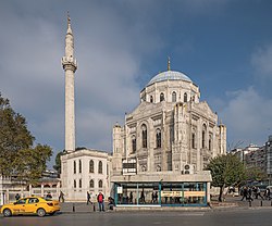
The Pertevniyal Valide Sultan Mosque stands by the busy road junction near Aksaray tram stop. Squeezed in between Aksaray and Yusufpaşa is the smaller, older and much less conspicuous Murad Pasha Mosque, built in 1473 in the early Ottoman architectural style perfected in Bursa. [4]

On Aksaray Square the wooden Hindiler (Horhor) Tekkesi has been rebuilt behind an austere stone fountain. The small Camcılar (Glaziers)Mosque is also being rebuilt on the edge of the square.

A little way along Vatan Caddesi stands the Fenari İsa Mosque which started life as the early 10th-century Byzantine Church of Constantine Lips. [5] Facing it across the road is the Yavuz Sultan Selim Medrese, a work of Mimar Sinan dating from 1549 now used as a clinic. Nearby is the tomb of one of Sultan Selim I's daughters, Şah-ı Huban, partially hidden by a stone schoolhouse. It, too, was designed by Mimar Sinan. [6]

Transport

Aksaray is the starting point for the M1 line which runs to the Atatürk International Airport, now no longer in use for passenger aircraft. The Otogar stop on the line serves the large inter-city bus terminus at Esenler.

Aksaray is also served by the T1 tram line.

Hub for sex trafficking

Aksaray is said to be a hub for the sex trafficking of young women from Romania, Moldova and Ukraine. [7] Some reports in the Turkish media have claimed that the neighbourhood is especially prone to prostitution because it is a "no man's land" between two adjoining police jurisdictions, Fatih and Eminönü. [8]

Related Research Articles

<span class="mw-page-title-main">Fener</span> Quarter in Marmara, Turkey

Fener is a quarter midway up the Golden Horn in the district of Fatih in Istanbul, Turkey. The Turkish name is derived from the Greek word "phanarion", meaning lantern, streetlight or lamppost; the neighborhood was so called because of a column topped with a lantern which stood here in the Byzantine period and was used as a street light or lighthouse.

<span class="mw-page-title-main">Ortaköy</span> District in Istanbul, Turkey

Ortaköy is a neighbourhood in the municipality and district of Beşiktaş, Istanbul Province, Turkey. Its population is 9,423 (2022). It is on the European shore of the Bosphorus. it was originally a small fishing village, known in Greek as Agios Fokas in the Byzantine period and then as Mesachorion.

<span class="mw-page-title-main">Fatih</span> Municipality in Istanbul, Turkey

Fatih is a municipality and district of Istanbul Province, Turkey. Its area is 15 km2, and its population is 368,227 (2022). It is home to almost all of the provincial authorities but not the courthouse. It encompasses the peninsula coinciding with old Constantinople. In 2009, the district of Eminönü, which had been a separate municipality located at the tip of the peninsula, was once again remerged into Fatih because of its small population. Fatih is bordered by the Golden Horn to the north and the Sea of Marmara to the south, while the Western border is demarked by the Theodosian wall and the east by the Bosphorus Strait.

Kurtuluş is a neighbourhood of the Şişli district of Istanbul that was originally called Tatavla, meaning 'stables' in Greek. The modern Turkish name means "liberation", "salvation", "independence" or "deliverance". On 13 April 1929, six years after the Republic of Turkey was founded, a fire swept through the neighbourhood and largely destroyed it, with 207 houses going up in flames. The name was changed to Kurtuluş to mark the rebuilding of the area.

<span class="mw-page-title-main">Arnavutköy</span> Neighbourhood in Beşiktaş, Istanbul, Turkey

Arnavutköy is a neighbourhood in the municipality and district of Beşiktaş, Istanbul Province, Turkey. Its population is 3,574 (2022). It is renowned for its wooden Ottoman mansions and seafood restaurants, as well as for the campus of the prestigious Robert College with its historic buildings. It is part of the Beşiktaş district of Istanbul, and is located between Ortaköy and Bebek on the European shoreline of the Bosphorus strait.

<span class="mw-page-title-main">Eyüp Sultan Mosque</span> Mosque in Istanbul, Turkey

The Eyüp Sultan Mosque is in the Eyüp district of Istanbul, outside the city walls and near the Golden Horn. On a much older site, the present building dates from the beginning of the 19th century. The mosque complex includes a mausoleum marking the spot where Ebu Eyüp el-Ansari, the standard-bearer and companion of the Islamic prophet Muhammad, is said to have been buried.

<span class="mw-page-title-main">Bağdat Avenue</span> Street in Istanbul, Turkey

Bağdat Avenue is one of the most important high streets on the Anatolian side of Istanbul, Turkey. It runs approximately 14 km (8.7 mi) from Maltepe in the east to Kadıköy in the west, almost paralleling the coastline of the Sea of Marmara. The most important part of the street runs 6 km (3.7 mi) from Bostancı to Kızıltoprak within the district of Kadıköy. Bağdat Avenue is usually seen as the counterpart of Istiklal Avenue on the European side of the city in terms of its importance and glamour although it lacks the fine heritage of historic buildings to be found on Istiklal Avenue with almost all its architecture modern.

<span class="mw-page-title-main">Balat, Fatih</span> Neighbourhood in Fatih, Istanbul, Turkey

Balat is a neighbourhood in the municipality and district of Fatih, Istanbul Province, Turkey. Its population is 11,656 (2022). It is in the old city on the European side of Istanbul, on the western shore of the Golden Horn, sandwiched between Fener and Ayvansaray. Historically, it was the centre of the Jewish community in Istanbul.

<span class="mw-page-title-main">Zeyrek</span> Neighbourhood in Fatih, Istanbul, Turkey

Zeyrek is a neighbourhood in the municipality and district of Fatih, Istanbul Province, Turkey. Its population is 12,863 (2022). It is a picturesque but poor neighbourhood. It takes its name from the huge and prominent Zeyrek Mosque which started life as a Byzantine church and sits on a plateau, overlooking the Golden Horn.

<span class="mw-page-title-main">Çarşamba, Fatih</span> Quarter in Marmara, Turkey

Çarşamba is a small part of the Fatih district of Istanbul, Turkey, close to the Fatih Mosque. It is one of the most conservative areas of the city.

The Yavuz Sultan Selim Medrese in Istanbul was built by Mimar Sinan in memory of Selim the first from 1548 till 1550. The medrese is also known as “Yenibahce Selim Medrese”. When Selim became Sultan his tent was deployed at the place where one now finds the medrese. At that time he uttered the wish to build an educational institution there. Later in 1563 by request of the population Mimar Sinan transformed the lecture hall into a mescid and a small minaret was added. 1914 a fire in the neighborhood slightly damaged the building. From 1918 on the former medrese was used as a public kitchen but unfortunately in the same year another fire affected the building. Not until 1958 a foundation started restoring the building to use it as a Museum. Regrettably the minaret lost in 1942 wasn’t repaired. In 1962 the Türk Hat Sanatlari Museum opened its gates. During the 1980s the building was empty till the Sadieye Hatun Company started using it as a hospital.

<span class="mw-page-title-main">Ayvansaray</span> Neighbourhood in Fatih, Istanbul, Turkey

Ayvansaray is a picturesque neighbourhood in the municipality and district of Fatih, Istanbul Province, Turkey. Its population is 15,747 (2022). It is on the Golden Horn, between Balat and Eyüpsultan. It lies inside what was the walled city on Constantinople and later of İstanbul and corresponds to the old quarter of Blachernae.

<span class="mw-page-title-main">Rüstem Pasha</span> Grand Vizier of the Ottoman Empire (1544–1553, 1555–1561)

Rüstem Pasha was an Ottoman statesman who served as Grand Vizier to Sultan Süleyman the Magnificent. Rüstem Pasha is also known as Damat Rüstem Pasha as a result of his marriage to the sultan's daughter, Mihrimah Sultan, in 1539. He is regarded as one of the most influential and successful grand viziers of the Ottoman Empire.

<span class="mw-page-title-main">Çemberlitaş, Fatih</span>

Çemberlitaş is a quarter in the Fatih district of Istanbul on the European side of the city. It takes its name from the Çemberlitaş Column, also known as the Column of Constantine, which stands beside the Çemberlitaş stop on the T1 tram line.

<span class="mw-page-title-main">Cistern of Aspar</span>

The Cistern of Aspar or Great Cistern, known in Turkish as Sultan Selim Çukurbostanı, was a Byzantine open-air water reservoir in the city of Constantinople.

<span class="mw-page-title-main">Emirgan</span> Neighborhood in Istanbul, Marmara, Turkey

Emirgan is a leafy, middle-class suburb of Istanbul, Turkey, on the western shore of the Bosphorus in the Sarıyer district north of the Fatih Sultan Mehmet Bridge.

Topkapı is a neighbourhood in the municipality and district of Fatih, Istanbul Province, Turkey. Its population is 10,218 (2022).

<span class="mw-page-title-main">Selimiye, Üsküdar</span> Neighborhood in Istanbul, Turkey

Selimiye is one of thirty-three neighbourhoods in the Üsküdar districton the Asian side of the Bosphorus in Istanbul, Turkey. It takes its name from Sultan Selim III who commissioned a barracks here that led to the creation of a new neighbourhood in its vicinity.

<span class="mw-page-title-main">Çamlıca, Üsküdar</span> Neighborhood of Istanbul

Çamlıca is a leafy district of Üsküdar on the Asian side of Istanbul. It is famous for two hills - Big Çamlıca and Little Çamlıca - offering panoramic views across the Sea of Marmara and the Princes' Islands to the European side of Istanbul and Sarayburnu. Historically, these were renowned beauty spots although by the end of the 20th century modern development had detracted from that beauty, not least when a series of radio and television towers were built on the hills.

References

  1. Mahalle, Turkey Civil Administration Departments Inventory. Retrieved 12 July 2023.
  2. "Address-based population registration system (ADNKS) results dated 31 December 2022, Favorite Reports" (XLS). TÜİK . Retrieved 12 July 2023.
  3. Mamboury (1953), p. 99
  4. Yale, Pat; Tonguç, Saffet Emre (2010). Istanbul : The Ultimate Guide (1st ed.). Istanbul: Boyut. pp. 89–90. ISBN   978-975-23-0734-6.
  5. "Monastery of Lips". The Byzantine Legacy. Retrieved 2022-09-30.
  6. Yale, Pat; Tonguç, Saffet Emre (2010). Istanbul : The Ultimate Guide (1st ed.). Istanbul: Boyut. p. 90. ISBN   978-975-23-0734-6.
  7. Frontline: Sex Slaves. Originally broadcast 2006.
  8. Counter Trafficking, Media Room Archived 2012-04-23 at the Wayback Machine

Sources