Akwete

Last updated

Akwete
Akwete Ndoki
Town
Nickname: 
Ndoki village
Nigeria location map.svg
Red pog.svg
Akwete
Location in Nigeria
Coordinates(NG): 4°53′14″N7°21′26″E / 4.88722°N 7.35722°E / 4.88722; 7.35722
Country Flag of Nigeria.svg Nigeria
State Abia State
LGA Ukwa East
Government
  TypeTraditional
Population
  Ethnicity
Igbo
  Religion
Christianity Omenala
Time zone UTC+1 (WAT)
National language Igbo

Akwete town is the headquarters of Ukwa East local government area of Abia state, Nigeria. Akwete is located 18 Kilometers northeast of the oil-rich city of Port Harcourt and 18 Kilometers southeast of the commercial city of Aba. Akwete is an important community of the Ndoki and Igbo people in general, they belong to the Umuihueze II clan. Akwete is known in West Africa for its unique weaving. [1]

Contents

In the early 19th-century Akwete was one of the main destinations of Aro slave traders and they brought Igbo and other people they had enslaved or purchased from other enslavers to the coast. One of the people who was brought to Akwete by this trade was Jaja of Opobo who later became the king of the city-state of Opobo. Akwete was also involved in the palm oil trade, and when Jaja was brought there while enslaved in about 1830 the palm oil trade had become the main export trade of Akwete. [2]

Etymology

The origin of the name Akwete has over the years been a subject of controversy. There is a version that asserts that the name Akwete emanated or originated from 'Aku-Ete'. This version is of the opinion that the name Akwete was derived from the rope palm tree cutters use in climbing the trees known as Ete. Another popular opinion is that the word emanates from the Ndoki Weaving Technology which Akwete women are famous for. [3]

Climate

The climate in Akwete is uncomfortable year-round and warm and foggy during the wet and dry seasons. The average annual temperature ranges from 67 to 90 degrees Fahrenheit, rarely falling below 60 or rising above 93. [4] [5] [6]

It is not fully meaningful to talk about hot and cold seasons in Akwete because the temperature there varies so little from season to season. [4] [7] [8]

Clouds

Over the course of the year, there is a considerable seasonal change in Akwete's average cloud cover 100%. [4] [9]

Around November 24 marks the start of Akwete's clearer season, which lasts for 2.6 months and ends around February 13. [4] [10]

In Akwete, December is the clearest month of the year, with the sky remaining clear, mostly clear, or partly cloudy 38% of the time. [4] [11]

Beginning about February 13 and lasting for 9.4 months, the cloudier period of the year ends around November 24. [4] [12] [13]

April is the cloudiest month of the year in Akwete, with the sky being overcast or mostly cloudy 88% of the time on average during that month. [4] [14]

Precipitation

A day that has at least 0.04 inches of liquid or liquid-equivalent precipitation is considered to be wet. In Akwete, the likelihood of rainy days varies wildly throughout the year. [4] [15]

The 7.7-month wetter season, which runs from March 20 to November 12, has a probability of precipitation of more than 47% on any one day. In Akwete, September has an average of 25.6 days with at least 0.04 inches of precipitation, making it the month with the most rainy days. [4]

Between November 12 until March 20, or 4.3 months, is the dry season. With an average of 2.7 days with at least 0.04 inches of precipitation, January is the month in Akwete with the fewest number of rainy days. [4]

We categorize wet days into those that include snow, rain, or a combination of the three. In Akwete, September has an average of 25.6 days of rain, which is the most of any month. This classification shows that rain alone is the most frequent type of precipitation throughout the year, with a high likelihood of 87% on September 12. [4]

Related Research Articles

<span class="mw-page-title-main">Umuahia</span> Capital city of Abia State, Nigeria

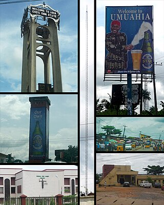
Umuahia is the capital city of Abia State in southeastern Nigeria. Umuahia is located along the rail road that lies between Port Harcourt to its south,and Enugu city to its north. Umuahia has a population of 359,230 according to the 2006 Nigerian census. Umuahia is indigenously Igbo.

Arochukwu Local Government Area, sometimes referred to as Arochuku or Aro Oke-Igbo, is the third largest local government area in Abia State in southeastern Nigeria and homeland of the Igbo subgroup, Aro people.

Yenagoa is a Local Government Area and capital city of Bayelsa State, Southern Nigeria. It is located at the Niger-Delta region of the country at coordinates 4°55′29″N6°15′51″E.

Ogoja is a Local Government Area in Cross River State, Nigeria. Its headquarters is Ogoja town in the northeast of the area near the A4 highway at 6°39′17″N8°47′51″E.

<span class="mw-page-title-main">Gboko</span> LGA in Benue state

Gboko is a Local Government Area in Benue state, North-central Nigeria. It is headquartered in the town of Gboko.

Bende is a Local Government Area in Abia State, Nigeria with headquarters located in Bende Community. Bende Local Government Area (L.G.A) of Abia state lies on 70 30I of the Greenwich Meridian and latitude 50 30I North of the Equator. It is composed of thirteen (13) communities, namely: Alayi, Bende, Ezukwu, Igbere, Item, Itumbuzo, Nkpa, Ntalakwu, Ozuitem, Ugwueke, Umu-imenyi, Umuhu-Ezechi, and Uzuakoli.

Ankpa is a Local Government Area in Kogi State, Nigeria. Its headquarters are in the town of Ankpa on the A233 highway in the west of the area at7°22′14″N7°37′31″E.

Demsa is a Local Government Area of Adamawa State, Nigeria with headquarters located in Demsa. Demsa lies on the Benue River.

<span class="mw-page-title-main">Ganye</span> LGA and town in Adamawa State, Nigeria

Ganye is a town and Local Government Area of Adamawa State, Nigeria. Jada and Toungo Local Governments were carved out from Ganye local government area of Adamawa state Nigeria. Ganye is bordered by Jada Local Government Area to the North and East, Toungo Local Government Area to the South and Taraba State to the West. It is the headquarter of the Sama (Chamba) people worldwide.

Gombi is the Local Government Headquarter of Gombi Local Government Area of Adamawa State, Nigeria.

<span class="mw-page-title-main">Mubi North</span> LGA in Adamawa State, Nigeria

Mubi North is a Local Government Area of Adamawa State, Nigeria. The town is the location of the Adamawa State University and the Federal Polytechnic, Mubi.

Aba South is a Local Government Area of Abia State, Nigeria. Its headquarters are in the city of Aba.

<span class="mw-page-title-main">Keffi</span> LGA and Town in Nasarawa State, Nigeria

Keffi Local Government Area and also is a traditional or commercial town in Nasarawa north central Nigeria Its headquarters are in the town of Keffi. Keffi is 50 kilometers from Abuja. Nasarawa State university is located in Keffi sitting along Keffi-Akwanga express way.

Ife South is a Local Government Area in Osun State, Nigeria. Its headquarters are in the town of Ifetedo at 7°11′00″N4°42′00″E.

Ede North is a Local Government Area in Osun State, Nigeria. Its headquarters as Abere.

Okpuala Ngwa is a town in Isiala-Ngwa North. It serves as the administrative headquarters for the local government. It was the first settlement and headquarters of the Ngwa people. The people of Okpuala Ngwa speak the Ngwa dialect of the Ngwa people.

Iperindo town is situated in the Osun region. Osogbo (Osogbo), the capital of Osun, lies about 42 kilometers from Iperindo. Iperindo and Abuja, the capital of Nigeria, are separated by a distance of roughly 341 kilometers.

Apomu is a medium-sized town in the Osun state. It has a population of about 71,656 people.

Bode Osi is a town in Osun State, Nigeria. It is located around 36 kilometres (22 mi) away from Osogbo, the capital of Osun State, and 370 kilometres (230 mi) from Abuja, the capital of Nigeria. Bode Osi is also the headquarters of Ola Oluwa Local Government Area.

Ndoki Ndoki also known as Ọkwa are a tribe of Igbo people and they are located at the hinterland of Igboland and coastal region of Bonny and Opobo.

References

  1. Akwete Cloth and Its Motifs, Marian Davis African Arts Vol. 7, No. 3 (Spring, 1974), pp. 22-25 Published by: UCLA James S. Coleman African Studies Center
  2. Sylvanus John Sodienye Cookey King Jaja of the Niger Delta: His Life and Times p. 28-29
  3. "Akwete cloth is a fabric of Igbo women of Akwete in Abia Nigeria". 3 May 2016.
  4. 1 2 3 4 5 6 7 8 9 10 11 "Akwete Climate, Weather By Month, Average Temperature (Nigeria) - Weather Spark". weatherspark.com. Retrieved 2023-07-26.
  5. "Akwete, Abia, NG Climate Zone, Monthly Averages, Historical Weather Data". tcktcktck.org. Retrieved 2023-07-26.
  6. https://www.accuweather.com/en/ng/akwete/251699/current-weather/251699
  7. Atlas, Weather. "Akwete, Nigeria - Yearly & Monthly weather forecast". Weather Atlas. Retrieved 2023-07-26.
  8. Atlas, Weather. "Akwete, Nigeria - Weather forecast & Hourly Temperature - Today". Weather Atlas. Retrieved 2023-07-26.
  9. "Weather in Akwete today". GISMETEO.COM. Retrieved 2023-07-26.
  10. "Weather Today Akwete". meteoblue. 2023-07-26. Retrieved 2023-07-26.
  11. "Akwete weather forecast for today". justweather.org. Retrieved 2023-07-26.
  12. "Akwete Air Quality Index (AQI) and Nigeria Air Pollution | IQAir". www.iqair.com. 2023-07-26. Retrieved 2023-07-26.
  13. Morel, Emilien. "Weather Akwete General Nigeria". Weather Avenue. Retrieved 2023-07-26.
  14. Atlas, Weather. "Akwanga, Nigeria - Weather forecast & Hourly Temperature - Today". Weather Atlas. Retrieved 2023-07-26.
  15. https://www.accuweather.com/en/ng/akwete/251699/hiking-weather/251699