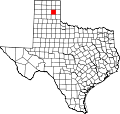
Alanreed | |
---|---|
Coordinates: 35°12′42″N100°43′57″W / 35.21167°N 100.73250°W | |
Country | United States |
State | Texas |
County | Gray |
Elevation | 3,012 ft (918 m) |
Population (2020) | |
• Total | 23 |
Time zone | UTC-6 (Central (CST)) |
• Summer (DST) | UTC-5 (CDT) |
GNIS feature ID | 2805780 [1] |
Alanreed is an unincorporated community and census-designated place (CDP) in Gray County, Texas, United States. It is part of the Pampa, Texas Micropolitan Statistical Area. It was first listed as a CDP in the 2020 census with a population of 23. [2]
The community was named for Alan and Reed, partners in the contracting firm that laid out the present townsite for the Choctaw, Oklahoma and Texas Railroad in 1900. An earlier name for the place was Gouge Eye, in honor of a memorable saloon brawl. [3]
Alanreed is accessible via Interstate 40 and FM 291. [4] Loop 271 through the community is a former alignment of the historic U.S. Route 66. [5]
The McLean Independent School District serves area students. It was formerly served by the defunct Alanreed Independent School District.
Census | Pop. | Note | %± |
---|---|---|---|
2020 | 23 | — | |
U.S. Decennial Census [6] 1850–1900 [7] 1910 [8] 1920 [9] 1930 [10] 1940 [11] 1950 [12] 1960 [13] 1970 [14] 1980 [15] 1990 [16] 2000 [17] 2010 [18] 2020 [19] |
Alanreed first appeared as a census designated place in the 2020 U.S. Census. [20] [19]
Race / Ethnicity (NH = Non-Hispanic) | Pop 2020 [19] | % 2020 |
---|---|---|
White alone (NH) | 23 | 100.00% |
Black or African American alone (NH) | 0 | 0.00% |
Native American or Alaska Native alone (NH) | 0 | 0.00% |
Asian alone (NH) | 0 | 0.00% |
Pacific Islander alone (NH) | 0 | 0.00% |
Other race alone (NH) | 0 | 0.00% |
Mixed race or Multiracial (NH) | 0 | 0.00% |
Hispanic or Latino (any race) | 0 | 0.00% |
Total | 23 | 100.00% |
Lipscomb is an unincorporated community and census-designated place (CDP) in Lipscomb County, Texas, United States. It is the Lipscomb county seat. The population was 66 at the 2020 census.
La Pryor is a census-designated place in Zavala County, Texas, United States. Its population was 1,294 at the 2020 census.
Alfred is an unincorporated community and census-designated place (CDP) northeast of Alice in Jim Wells County, Texas, United States. Its population was 291 as of the 2010 census. It is known for the outdoor flea markets held on the first whole weekend of the month.
Shiro is an unincorporated community and census-designated place (CDP) in Grimes County, Texas, United States located on State Highway 30 and the BNSF Railway in east central Grimes County.
Bonanza Hills is a census-designated place in Webb County, Texas, United States. The population was 37 at the 2010 census. This was a new CDP, formed from parts of the Botines CDP and additional area prior to the 2010 census.
Big Thicket Lake Estates is a census-designated place (CDP) in Polk and Liberty counties, Texas, United States. This was a new CDP for the 2010 census, with a population of 742, decreasing to 514 at the 2020 census.
Olmito and Olmito is a census-designated place (CDP) in Starr County, Texas, United States. It is a new CDP, formed from part of the old La Victoria CDP prior to the 2010 census, with a population of 271.
JF Villarreal is a census-designated place (CDP) in Starr County, Texas, United States. It is a new CDP, formed from part of the North Escobares CDP prior to the 2010 census, with a population of 104.
Evergreen is a census-designated place (CDP) in Starr County, Texas, United States. It is a new CDP, formed from part of the Roma Creek CDP prior to the 2010 census, with a population of 73.
Fronton Ranchettes is a census-designated place (CDP) in Starr County, Texas, United States. It is a new CDP, formed from part of the Roma Creek CDP prior to the 2010 census, with a population of 113.
Ramos is a census-designated place (CDP) in Starr County, Texas, United States. It is a new CDP, formed from part of the Roma Creek CDP prior to the 2010 census, with a population of 116.
H. Cuellar Estates is a census-designated place (CDP) in Starr County, Texas, United States. It is a new CDP, formed from part of the Falcon Heights CDP prior to the 2010 census. In the 2020 census, it had a population of 11, down from 20 in the 2010 census.
Lago Vista is a census-designated place (CDP) in Starr County, Texas, United States. It is a new CDP, formed from part of the Falcon Heights CDP prior to the 2010 census. The CDP had a population of 133 in the 2020 census, up from 115 in the 2010 census.
Mesquite is a census-designated place (CDP) in Starr County, Texas, United States. It is a new CDP, formed from part of the former Escobares CDP prior to the 2010 census, with a population of 505.
Airport Heights is an unincorporated community and census-designated place (CDP) in Starr County, Texas, United States. This was a new CDP for the 2010 census, with a population of 161.
Jardin de San Julian is a census-designated place (CDP) in Starr County, Texas, United States. This was a new CDP for the 2010 census, with a population of 22.
Los Arrieros is an unincorporated community and census-designated place in Starr County, Texas, United States. Its population was 91 as of the 2010 census. U.S. Route 83 passes through the community.
Fort Clark Springs is an unincorporated community and census-designated place (CDP) in Kinney County, Texas, United States. The population was 1,228 at the 2010 census. It is the site of the former Fort Clark, now a historic district.
Lamkin is an unincorporated community and census-designated place (CDP) in Comanche County, Texas, United States. It was first listed as a CDP prior to the 2020 census.
Sunrise Shores is an unincorporated community and census-designated place (CDP) in Henderson County, Texas, United States. It was first listed as a CDP prior to the 2020 census.