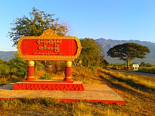
Hkamti Township or Khamti Township is a township in Hkamti District in the Sagaing Region of Burma (Myanmar). The principal town is Hkamti. As of 2014 the township had a population of 47,658 people and covered an area of 8,174 square kilometres (3,156 sq mi). The township is dominated by the Chindwin River and its tributaries as well as thickly forested areas. Nearly half the active working population are employed in agriculture, forestry or fishing. The township is a producer of rice and has gold and jade reserves.
Gyobin is a river town in Homalin Township, Hkamti District, in the Sagaing Region of northwestern Burma. It is located east of Kaukngo. An old frontier outpost was located at Gyobin during the British Burma period.
Kawya is a village on the Chindwin River in Homalin Township, Hkamti District, in the Sagaing Region of northwestern Burma. It is located north of the town of Homalin and south of Maungkan, about half way. Gardens were planted in Kawya and other nearby villages around 1700 and the village has been documented as producing pickled tea, known as "letpet".
Yebawmi is a river village in Homalin Township, Hkamti District, in the Sagaing Region of northwestern Burma. It is located near Hwepanan. Yebawmi lies on the banks of the Uyu River and is noted for its salt springs and waistcloth weaving.
Maingkaing is a village in Homalin Township, Hkamti District, in the Sagaing Region of northwestern Burma.
Metkalet is a village in Homalin Township, Hkamti District, in the Sagaing Region of northwestern Burma.
Monkali is a village in Homalin Township, Hkamti District, in the Sagaing Region of northwestern Burma. It lies on the banks of the Chindwin River, south of Homalin town.
Pebin is a village in Homalin Township, Hkamti District, in the Sagaing Region of northwestern Burma.
Sedaw is a village in Homalin Township, Hkamti District, in the Sagaing Region of northwestern Burma.
Ingyaw is a river village in Kale Township, Kale District, in the Sagaing Region of western Burma. It is located to the east of the town of Kalaymyo.
Kyigon is a village in Kale Township, Kale District, in the Sagaing Region of western Burma (Myanmar). Kyigon is located on the left (north) bank of the Myittha River about 2.4 kilometres (1.5 mi) above where the Neyinzaya River enters the Myittha. It is about 8.8 kilometres (5.5 mi) northeast of the regional capital at Kalemyo.
Zanabok is a town in Mingin Township, Kale District, in the Sagaing Region of western Burma.

Okpho Township or Okpo Township is a township in Tharrawaddy District in the Bago Region of Burma. The principal town is Okpho.
Okpho is a small town and seat of Okpho Township, Tharrawaddy District, in the Bago Region of southern-central Myanmar. It lies south of Gyobingauk and north of Minhla. It contains a hospital, a pagoda, and an open ground in the town centre. It is located 177 kilometres (110 mi) north of Yangon. The Okpho Railway Station is operated by Myanmar Railways and the town also contains a police station.
Gyobingauk is a town and seat of Gyobingauk Township, Tharrawaddy District, in the Bago Region of southern-central Burma. It lies approximately 10 kilometres north of Okpho along National Highway 2. It is located roughly 185 kilometres north of Yangon. The town has a Roman Catholic history with missionaries. It was reorganized in 1951 as the city headquarters. It is said that the city was named after GyoBinGauk because of buckling Gyo Tree's location at long times ago.

Sike Khaung or Sai Khao is a village in Hsi Hseng Township, Taunggyi District, Pa'O Self-Administered Zone, in the Shan State of eastern Myanmar. It is located north of the township capital of Hsi Hseng by National Highway 5. Nawnge and Lothkan are located to the west, Loimut to the southeast, and Hsohsa to the northeast.
Hsohsa is a village in Hsi Hseng Township, Taunggyi District, in the Shan State of eastern Burma. It is located northeast of the town of Loisawn. It is a primary agricultural village, with extensive fields around it. The village is named after Hso Hsa Hpa, a ruler of ancient Shan who was the son of Sao Pet Law.
Maihpit is a village in Hsi Hseng Township, Taunggyi District, in the Shan State of eastern Burma. It is located southwest of Nawnghkathpa and Loisawn. It is a primarily agricultural village with extensive fields surrounding it.

Langkho, Laangkher, or Linkhay is a town and seat of Langkho Township and Langkho District, in the Shan State of eastern Burma. It is located east of Wān Long. It is served by Langhko Airport and is accessed along the National Road 45. A bridge in the vicinity crossing the Nam Teng River the town lies on is called Nam Kok Bridge. This town is famous for being the subject of the song "Langkho A Win", written by Sai Htee Saing.


