
The Bernese Alps are a mountain range of the Alps, located in western Switzerland. Although the name suggests that they are located in the Berner Oberland region of the canton of Bern, portions of the Bernese Alps are in the adjacent cantons of Valais, Fribourg and Vaud, the latter being usually named Fribourg Alps and Vaud Alps respectively. The highest mountain in the range, the Finsteraarhorn, is also the highest point in the canton of Bern.

Mount Elbrus is the highest and most prominent peak in Russia and Europe. It is situated in the western part of the Caucasus and is the highest peak of the Caucasus Mountains. The dormant volcano rises 5,642 m (18,510 ft) above sea level; it is the highest stratovolcano in Eurasia, as well as the tenth-most prominent peak in the world. The mountain stands in Southern Russia, in the Russian republic of Kabardino-Balkaria.

The Matterhorn is a mountain of the Alps, straddling the main watershed and border between Switzerland and Italy. It is a large, near-symmetric pyramidal peak in the extended Monte Rosa area of the Pennine Alps, whose summit is 4,478 metres (14,692 ft) high, making it one of the highest summits in the Alps and Europe. The four steep faces, rising above the surrounding glaciers, face the four compass points and are split by the Hörnli, Furggen, Leone/Lion, and Zmutt ridges. The mountain overlooks the Swiss town of Zermatt, in the canton of Valais, to the north-east and the Italian town of Breuil-Cervinia in the Aosta Valley to the south. Just east of the Matterhorn is Theodul Pass, the main passage between the two valleys on its north and south sides, which has been a trade route since the Roman Era.

A mountain pass is a navigable route through a mountain range or over a ridge. Since many of the world's mountain ranges have presented formidable barriers to travel, passes have played a key role in trade, war, and both human and animal migration throughout history. At lower elevations it may be called a hill pass. A mountain pass is typically formed between two volcanic peaks or created by erosion from water or wind.

Cascade Mountain is in Essex County of New York. It is one of the 46 Adirondack High Peaks (36th) and is located in the Adirondack Park. Its name comes from a series of waterfalls on a brook near the mountain's base. The lake it flows into and the pass between Cascade and Pitchoff mountains are also named Cascade.

Tehachapi Pass is a mountain pass crossing the Tehachapi Mountains in Kern County, California. Traditionally, the pass marks the northeast end of the Tehachapis and the south end of the Sierra Nevada range.

Donner Pass is a 7,056-foot-high (2,151 m) mountain pass in the northern Sierra Nevada, above Donner Lake and Donner Memorial State Park about 9 miles (14 km) west of Truckee, California. Like the Sierra Nevada mountains themselves, the pass has a steep approach from the east and a gradual approach from the west.

Porter Mountain is one of the Adirondack High Peaks. It is number 38 in order of height, and one of the easier hikes of the Adirondack Forty-Sixers. It is named after Noah Porter, one of the first to climb it, later president of Yale University.

Cajon Pass is a mountain pass between the San Bernardino Mountains to the east and the San Gabriel Mountains to the west in Southern California. Created by the movements of the San Andreas Fault, it has an elevation of 3,777 ft (1,151 m). Located in the Mojave Desert, the pass is an important link from the Greater San Bernardino Area to the Victor Valley, and northeast to Las Vegas.

Huayna Potosí is a mountain in Bolivia, located near El Alto and about 25 km north of La Paz in the Cordillera Real.

Coquihalla Summit is a highway summit along the Coquihalla Highway in British Columbia, Canada. It is the highest point on the highway between the cities of Hope and Merritt. It is located just south of the former toll booth plaza on the Coquihalla Highway, about 50 km (31 mi) north of Hope, and 65 km (40 mi) south of Merritt and is the divide between the Coquihalla River and the Coldwater River.
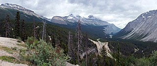
Sunwapta Pass is a mountain pass in the Canadian Rockies in the province of Alberta. Sunwapta Pass is the low point of the saddle created between Mount Athabasca and Nigel Peak. The pass marks the boundary between Banff and Jasper National Parks. The Icefields Parkway travels through Sunwapta Pass 108 km (67 mi) southeast of the town of Jasper and 122 km (76 mi) northwest of the Parkway's junction with the Trans-Canada Highway near Lake Louise. The pass is the second highest point on the Icefields Parkway. Bow Summit in Banff National Park is the highest point on the parkway.
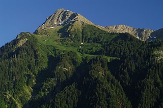
The Niesen is a mountain peak of the Bernese Alps in the Canton of Bern, Switzerland. The summit of the mountain is 2,362 metres (7,749 ft) in elevation.
Mount Raimer, 2,572 feet (784 m), is a prominent peak in the Taconic Mountains of western Massachusetts and adjacent New York. The west side and summit are located in New York; the east slopes lie within Massachusetts. The summit ridge is part meadow and part wooded with red spruce, balsam fir, and northern hardwood tree species. It is notable for its views of the Hoosic River valley and Hudson River Valley. The 35 mi (56 km) Taconic Crest Trail traverses the mountain. Much of the upper slopes and summit are within protected conservation land. The mountain is the location of a defunct ski area.
The Spillgerte is a mountain of the Bernese Alps, located east of Zweisimmen in the Bernese Oberland. The mountain lies between the valleys of Diemtigen and Simmental, a few kilometres north of the Albristhorn. It is composed of several summits of which the Hinderi Spillgerte is the highest.

The Hahnenmoos Pass is a mountain pass of the Bernese Alps. The pass crosses the col between the peaks of Regenboldshorn and Albristhorn, at an elevation of 1,950 m (6,400 ft). The Hahnenmoos Pass is the lowest pass between the Engstligental, to the east, and the upper Simmental, to the west.

Grizzly Peak is a high mountain summit in the Front Range of the Rocky Mountains of North America. Also known as Grizzly Peak D, the 13,433-foot (4,094 m) thirteener is located in Arapaho National Forest, 2.1 miles (3.4 km) southeast by east of Loveland Pass, Colorado, United States, on the Continental Divide between Clear Creek and Summit counties. Its proximate parent peak is Torreys Peak.

The Regenboldshorn is a mountain of the Bernese Alps, located between Lenk and Adelboden in the canton of Bern. It lies south of the Hahnenmoos Pass, at the foot of the Ammertenspitz.

The saddle between two hills is the region surrounding the highest point of the lowest point on the line tracing the drainage divide connecting the peaks. When, and if, the saddle is navigable, even if only on foot, the saddle of a (optimal) pass between the two massifs, is the area generally found around the lowest route on which one could pass between the two summits, which includes that point which is a mathematically when graphed a relative high along one axis, and a relative low in the perpendicular axis, simultaneously; that point being by definition the col of the saddle.

