
Minam is an unincorporated community in northwestern Wallowa County, Oregon, United States. It is located at the confluence of the Minam and Wallowa rivers, north of the Wallowa Mountains on Oregon Route 82. Minam is approximately 20 miles (32 km) Northeast of La Grande.

Flora is an unincorporated community in Wallowa County, Oregon, United States. It is located about 35 miles north of Enterprise, just off Oregon Route 3, and is considered a ghost town. Its elevation is 4350 ft. The community includes 6 mines.
Ash is an unincorporated community in Douglas County, Oregon, United States, south of Loon Lake in the Southern Oregon Coast Range. The community is also referred to as Ash Valley.

Algoma is an unincorporated community on the east shore of Upper Klamath Lake, in Klamath County, Oregon, United States. It is about 8 miles (13 km) north of the city of Klamath Falls on U.S. Route 97. Algoma was named for the Algoma Lumber Company.
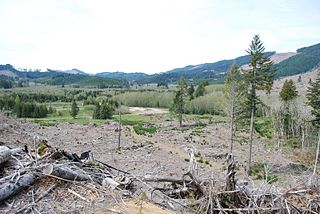
Valsetz was an unincorporated community and timber company town in Polk County, Oregon, United States, west of Falls City in the Central Oregon Coast Range. It no longer exists.
Imnaha is an unincorporated community at the confluence of Big Sheep Creek and the Imnaha River in Wallowa County, Oregon, United States. Its elevation is 1,978 feet (603 m). Oregon Route 350 connects Imnaha to the nearest incorporated city, Joseph, 30 miles (48 km) to the west. Imnaha is best known as the gateway to the Hat Point scenic lookout on Hells Canyon at the Snake River.

Whitney is an unincorporated community, also considered a ghost town, in Baker County, Oregon, United States, on Oregon Route 7 southwest of Sumpter. It is on the North Fork Burnt River, near the Blue Mountains and Wallowa-Whitman National Forest.

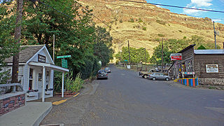
Copperfield is a former town in Baker County, in the U.S. state of Oregon. It is on the west bank of the Snake River and the north bank of Pine Creek, downstream of a feature of the Snake River known as The Oxbow. Copperfield Park, managed by Idaho Power, occupies the former town site. The Geographic Names Information System also lists Copperfield as a variant name for Oxbow, Oregon.
Buena Vista is an unincorporated community in Polk County, Oregon, United States. It is located on the Willamette River, and is the western landing for the Buena Vista Ferry. It is approximately 7 miles (11 km) south-southeast of Independence.

Irving was an unincorporated community in Lane County, Oregon, United States, and now partly within the Eugene city limits.

Chitwood is an unincorporated community in Lincoln County, Oregon, United States. Chitwood lies on U.S. Route 20 between Toledo to the west and Eddyville to the east. The Yaquina River flows through Chitwood.
Paradise is an unincorporated community in Wallowa County, Oregon, United States, about three miles east of Oregon Route 3 and about six miles south of the Oregon-Washington border. It is located on a plateau that overlooks Joseph Canyon. The closest incorporated cities are Enterprise, Oregon and Asotin, Washington at 40 and 45 miles away, respectively. Its elevation is 4114 feet.

Wilkesboro is an unincorporated community in Washington County, Oregon, United States. It is located on Oregon Route 6, one mile east of Banks.
Goldson is an unincorporated community in Lane County, Oregon, United States on Oregon Route 36 near Bear Creek, about 3.5 miles (5.6 km) from Cheshire. Goldson post office was established in 1891 and named for the first postmaster, J. M. Goldson. It ran until 1934. The community's elevation is 404 feet (123 m).
Cold Springs is an unincorporated community in Umatilla County, Oregon, United States, south of the Columbia River in the Hermiston area. Cold Springs Junction is a populated place and highway junction about 4 miles (6 km) northeast of Cold Springs at the junction of Oregon Route 37 and U.S. Route 730.

Blooming is an unincorporated community in Washington County, Oregon, United States near the Tualatin River, about two miles south of Cornelius. Its elevation is 190 feet. There are several plant nurseries in the area.
Orodell, also known as Oro Dell, is an unincorporated historic community in Union County, Oregon, United States, on the Grande Ronde River at the northwest edge of La Grande. It is considered a ghost town. Either Charles Fox or Stephen Coffin started the first sawmill in the Grande Ronde Valley there in the summer of 1862, after a joint-stock company between Coffin and other local settlers failed to materialize in 1861.
Tiernan is an unincorporated community in Lane County, Oregon, United States. It is about five miles west of Mapleton on Oregon Route 126 near the Siuslaw River and within the Siuslaw National Forest.
Airlie is an unincorporated community in Polk County, Oregon, United States.
Crowley is an unincorporated community in Polk County, Oregon, United States. It is located east of Oregon Route 99W, about four miles north of Rickreall.
