Alfalfa Center is an unincorporated community in Mississippi County, in the U.S. state of Missouri. [1]
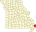
Mississippi County is a county located in the Bootheel of the U.S. state of Missouri, with its eastern border formed by the Mississippi River. As of the 2010 census, the population was 14,358. The largest city and county seat is Charleston. The county was officially organized on February 14, 1845, and was named after the Mississippi River.
In the United States, a state is a constituent political entity, of which there are currently 50. Bound together in a political union, each state holds governmental jurisdiction over a separate and defined geographic territory and shares its sovereignty with the federal government. Due to this shared sovereignty, Americans are citizens both of the federal republic and of the state in which they reside. State citizenship and residency are flexible, and no government approval is required to move between states, except for persons restricted by certain types of court orders.
Missouri is a state in the Midwestern United States. With over six million residents, it is the 18th-most populous state of the Union. The largest urban areas are St. Louis, Kansas City, Springfield and Columbia; the capital is Jefferson City. The state is the 21st-most extensive in area. Missouri is bordered by eight states : Iowa to the north, Illinois, Kentucky and Tennessee to the east, Arkansas to the south and Oklahoma, Kansas and Nebraska to the west. In the South are the Ozarks, a forested highland, providing timber, minerals and recreation. The Missouri River, after which the state is named, flows through the center of the state into the Mississippi River, which makes up Missouri's eastern border.
Alfalfa Center was laid out in 1935, and named for a local alfalfa processing factory. [2]
Alfalfa, also called lucerne and called Medicago sativa in binomial nomenclature, is a perennial flowering plant in the legume family Fabaceae. It is cultivated as an important forage crop in many countries around the world. It is used for grazing, hay, and silage, as well as a green manure and cover crop. The name alfalfa is used in North America. The name lucerne is the more commonly used name in the United Kingdom, South Africa, Australia, and New Zealand. The plant superficially resembles clover, especially while young, when trifoliate leaves comprising round leaflets predominate. Later in maturity, leaflets are elongated. It has clusters of small purple flowers followed by fruits spiralled in 2 to 3 turns containing 10–20 seeds. Alfalfa is native to warmer temperate climates. It has been cultivated as livestock fodder since at least the era of the ancient Greeks and Romans. Alfalfa sprouts are a common ingredient in dishes made in South Indian cuisine.
Buckeye is an unincorporated community in Mississippi County, in the U.S. state of Missouri.
Catalpa is an unincorporated community in Mississippi County, in the U.S. state of Missouri.
Crosno is an extinct town in Mississippi County, in the U.S. state of Missouri. The GNIS classifies it as a populated place.
Fuget is an extinct town in Mississippi County, in the U.S. state of Missouri. The GNIS classifies it as a populated place.
Greenfield is an extinct town in Mississippi County, in the U.S. state of Missouri. The GNIS classifies it as a populated place.
Hallett is an extinct town in Mississippi County, in the U.S. state of Missouri.
Henson is an unincorporated community in Mississippi County, in the U.S. state of Missouri.
Pulltight is an unincorporated community in Mississippi County, in the U.S. state of Missouri.
Samos is an unincorporated community in Mississippi County, in the U.S. state of Missouri.
Texas Bend is an unincorporated community in Mississippi County, in the U.S. state of Missouri.
Whiting is an unincorporated community in Mississippi County, in the U.S. state of Missouri.
Long Prairie Township is an inactive township in Mississippi County, in the U.S. state of Missouri.
Mississippi Township is an inactive township in Mississippi County, in the U.S. state of Missouri.
Ohio Township is an inactive township in Mississippi County, in the U.S. state of Missouri.
James Bayou Township is an inactive township in Mississippi County, in the U.S. state of Missouri.
St. James Township is an inactive township in Mississippi County, in the U.S. state of Missouri.
Wolf Island Township is an inactive township in Mississippi County, in the U.S. state of Missouri.
Fourteen Bend is an extinct town in Pemiscot County, in the U.S. state of Missouri.
Toppertown is an unincorporated community in Stoddard County, in the U.S. state of Missouri.
Okahola is an unincorporated community in Lamar County, in the U.S. state of Mississippi.
Coordinates: 36°57′47″N89°12′26″W / 36.96306°N 89.20722°W
A geographic coordinate system is a coordinate system that enables every location on Earth to be specified by a set of numbers, letters or symbols. The coordinates are often chosen such that one of the numbers represents a vertical position and two or three of the numbers represent a horizontal position; alternatively, a geographic position may be expressed in a combined three-dimensional Cartesian vector. A common choice of coordinates is latitude, longitude and elevation. To specify a location on a plane requires a map projection.
This Mississippi County, Missouri state location article is a stub. You can help Wikipedia by expanding it. |