Wilson City, Missouri

Last updated

Wilson City, Missouri
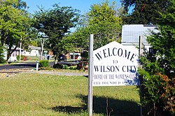
Wilson-City-sign-mo.jpg
Wilson City
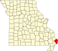
Mississippi County Missouri Incorporated and Unincorporated areas Wilson City Highlighted.svg
Location in Mississippi County and the state of Missouri
Coordinates: 36°55′25″N89°13′23″W / 36.92361°N 89.22306°W / 36.92361; -89.22306
Country Flag of the United States.svg  United States
State Flag of Virginia.svg  Virginia
County Mississippi
Area
[1]
  Total0.07 sq mi (0.19 km2)
  Land0.07 sq mi (0.19 km2)
  Water0.00 sq mi (0.00 km2)
Elevation
[2]
312 ft (95 m)
Population
 (2020) [3]
  Total77
  Density1,026.67/sq mi (395.29/km2)
Time zone UTC-6 (Central (CST))
  Summer (DST) UTC-5 (CDT)
ZIP Code
63882 (Wyatt)
FIPS code 29-80260 [4]
GNIS feature ID2399708 [2]

Wilson City is a village in Mississippi County, Missouri, United States. The population was 77 at the 2020 census. [3]

Contents

History

Wilson City was one of several villages constructed in the early 1940s as part of the "Delmo Project", an initiative by the Farm Security Administration to aid displaced tenant farmers. The village was initially known as "North Wyatt", or the "North Wyatt Group", but had adopted its current name by the late 1960s. The Delmo villages were segregated by race, and Wilson City was one of four Delmo villages designated for African Americans. [5] [6]

Geography

Wilson City is situated in northeastern Mississippi County, 5 miles (8 km) southwest of the confluence of the Mississippi and Ohio rivers. The small city of Wyatt lies along Missouri Route 77, a mile south of Wilson City. U.S. Route 62 connects Wilson City with Charleston, the county seat, to the west and Cairo, Illinois, to the northeast. [7]

According to the U.S. Census Bureau, Wilson City has a total area of 0.08 square miles (0.21 km2), all land. [1]

Demographics

Historical population
CensusPop.Note
1960 274
1970 2957.7%
1980 3094.7%
1990 210−32.0%
2000 165−21.4%
2010 115−30.3%
2020 77−33.0%
U.S. Decennial Census [8]

2020 census

Wilson City, Missouri – Racial and ethnic composition
Note: the US Census treats Hispanic/Latino as an ethnic category. This table excludes Latinos from the racial categories and assigns them to a separate category. Hispanics/Latinos may be of any race.
Race / Ethnicity (NH = Non-Hispanic)Pop 2000 [9] Pop 2010 [10] Pop 2020 [11] % 2000% 2010% 2020
White alone (NH)6323.64%2.61%2.60%
Black or African American alone (NH)1591126996.36%97.39%89.61%
Native American or Alaska Native alone (NH)0000.00%0.00%0.00%
Asian alone (NH)0000.00%0.00%0.00%
Pacific Islander alone (NH)0000.00%0.00%0.00%
Other race alone (NH)0000.00%0.00%0.00%
Mixed race or Multiracial (NH)0030.00%0.00%3.90%
Hispanic or Latino (any race)0030.00%0.00%3.90%
Total16511577100.00%100.00%100.00%

2010 census

As of the census [12] of 2010, there were 115 people, 56 households, and 25 families residing in the village. The population density was 1,437.5 inhabitants per square mile (555.0/km2). There were 74 housing units at an average density of 925.0 per square mile (357.1/km2). The racial makeup of the village was 2.61% White and 97.39% Black or African American.

There were 56 households, of which 19.6% had children under the age of 18 living with them, 5.4% were married couples living together, 30.4% had a female householder with no husband present, 8.9% had a male householder with no wife present, and 55.4% were non-families. 51.8% of all households were made up of individuals, and 14.3% had someone living alone who was 65 years of age or older. The average household size was 2.05 and the average family size was 3.08.

The median age in the village was 49.8 years. 19.1% of residents were under the age of 18; 6.1% were between the ages of 18 and 24; 21.8% were from 25 to 44; 33.9% were from 45 to 64; and 19.1% were 65 years of age or older. The gender makeup of the village was 47.8% male and 52.2% female.

2000 census

As of the census [4] of 2000, there were 165 people, 70 households, and 38 families residing in the village. The population density was 2,128.6 inhabitants per square mile (821.9/km2). There were 84 housing units at an average density of 1,083.7 per square mile (418.4/km2). The racial makeup of the village was 3.64% White and 96.36% African American.

There were 70 households, out of which 24.3% had children under the age of 18 living with them, 18.6% were married couples living together, 25.7% had a female householder with no husband present, and 44.3% were non-families. 34.3% of all households were made up of individuals, and 11.4% had someone living alone who was 65 years of age or older. The average household size was 2.36 and the average family size was 2.95.

In the village, the population was spread out, with 26.1% under the age of 18, 4.2% from 18 to 24, 27.9% from 25 to 44, 24.8% from 45 to 64, and 17.0% who were 65 years of age or older. The median age was 40 years. For every 100 females, there were 87.5 males. For every 100 females age 18 and over, there were 74.3 males.

The median income for a household in the village was $15,417, and the median income for a family was $23,750. Males had a median income of $35,417 versus $23,000 for females. The per capita income for the village was $11,068. About 37.5% of families and 39.5% of the population were below the poverty line, including 28.8% of those under the age of eighteen and 71.0% of those 65 or over.
Notable people

Related Research Articles

<span class="mw-page-title-main">Carthage, Arkansas</span> Town in Arkansas, United States

Carthage is a town in Dallas County, Arkansas, United States. The population was 343 at the 2010 census.

<span class="mw-page-title-main">Belleair Bluffs, Florida</span> City in Florida, United States

Belleair Bluffs is a city in Pinellas County, Florida, United States. It is part of the Tampa–St. Petersburg–Clearwater Metropolitan Statistical Area, more commonly known as the Tampa Bay Area. The population was 2,311 at the 2020 census.

<span class="mw-page-title-main">Madison, Illinois</span> City in Illinois, United States

Madison is a city in Madison and St. Clair counties in the U.S. state of Illinois. The population was 3,171 at the 2020 census, down from 3,891 in 2010. It is home to World Wide Technology Raceway at Gateway and the first Bulgarian Orthodox church in the United States.

<span class="mw-page-title-main">Venice, Illinois</span> City in Illinois, United States

Venice is a city in Madison County, Illinois, United States. The population was 1,498 at the 2020 census, down from 1,890 in 2010.

<span class="mw-page-title-main">Fairland, Maryland</span> Census-designated place in Maryland, United States

Fairland is a census-designated place and an unincorporated area in Montgomery County, Maryland, United States. It had a population of 25,396 per the 2020 census.

<span class="mw-page-title-main">Lauderdale, Minnesota</span> City in Minnesota, United States

Lauderdale is a city in Ramsey County, Minnesota, United States. The population was 2,379 at the 2010 census. Lauderdale is part of the Minneapolis–St. Paul metropolitan area and is surrounded by Minneapolis, St. Paul, Roseville, and Falcon Heights. Along with Roseville, it is one of two cities to touch both Minneapolis and St Paul.

<span class="mw-page-title-main">Wyatt, Missouri</span> City in Missouri, United States

Wyatt is a city in Mississippi County, Missouri, United States. The population was 219 at the 2020 census, down from 319 in 2010. It is the easternmost city west of the Mississippi River.

<span class="mw-page-title-main">Bel-Ridge, Missouri</span> City in Missouri, United States

Bel-Ridge is a suburban city in northern St. Louis County, Missouri, United States. The population was 2,737 at the 2010 census. Bel-Ridge is part of the Normandy Schools Collaborative. Bel-Ridge became a city in 2015 by a vote of the voters.

<span class="mw-page-title-main">Bellerive Acres, Missouri</span> City in Missouri, United States

Bellerive Acres is a northern suburban city in St. Louis County, Missouri, United States. The population was 188 at the 2010 census. In April, 2015, the residents voted to change the village of Bellerive to a fourth class city named Bellerive Acres.

<span class="mw-page-title-main">Black Jack, Missouri</span> City in Missouri, United States

Black Jack is a second-ring suburb of St. Louis, located in northern St. Louis County, Missouri, United States. The population was 6,929 at the 2010 census.

<span class="mw-page-title-main">Cool Valley, Missouri</span> City in Missouri, United States

Cool Valley is a city in St. Louis County, Missouri, United States in Greater St. Louis. The population was 1,196 at the 2010 census.

<span class="mw-page-title-main">Country Life Acres, Missouri</span> Village in Missouri, United States

Country Life Acres is a village in St. Louis County, Missouri, United States. The population was 72 at the 2020 census.

<span class="mw-page-title-main">Hillsdale, Missouri</span> Village in Missouri, United States

Hillsdale is a village in St. Louis County, Missouri, United States. Greenwood Cemetery is located in Hillsdale. The population was 1,478 at the 2010 census.

<span class="mw-page-title-main">Jennings, Missouri</span> City in Missouri, United States

Jennings is a city in St. Louis County, Missouri, United States. Per the 2020 census, the population was 12,895.

<span class="mw-page-title-main">Twin Oaks, Missouri</span> City in Missouri, United States

Twin Oaks is a 4th class city in St. Louis County, Missouri, United States. The former Village of Twin Oaks changed its status to that of a city by public election in November 2016. The population was 392 at the 2010 census.

<span class="mw-page-title-main">Velda Village Hills, Missouri</span> City in Missouri, United States

Velda Village Hills is a city in northeastern St. Louis County, Missouri, United States. The population was 1,055 at the 2010 census.

<span class="mw-page-title-main">Baker, Missouri</span> Village in Missouri, United States

Baker is an inactive incorporated village in Stoddard County, Missouri, United States. Per the 2020 census, the population was 3. As of 2017, it is Missouri's smallest incorporated settlement.

<span class="mw-page-title-main">Pinhook, Missouri</span> Inactive Village in Missouri, United States

Pinhook is an inactive village in Mississippi County, Missouri, United States. The population was 6 at the 2020 census, down from 30 in 2010.

<span class="mw-page-title-main">Castle Point, Missouri</span> Place in Missouri, United States

Castle Point is an unincorporated community and census-designated place (CDP) in St. Louis County, Missouri, United States. The population was 3,962 at the 2010 census.

<span class="mw-page-title-main">Urbancrest, Ohio</span> Village in Ohio, United States

Urbancrest is a village in Franklin County, Ohio, United States. The population was 1,031 at the 2020 census. Urbancrest is in the South-Western City Schools District.

References

  1. 1 2 "2023 U.S. Gazetteer Files: Missouri". United States Census Bureau. Retrieved April 25, 2024.
  2. 1 2 U.S. Geological Survey Geographic Names Information System: Wilson City, Missouri
  3. 1 2 "P1. Race – Wilson City village, Missouri: 2020 DEC Redistricting Data (PL 94-171)". U.S. Census Bureau. Retrieved April 25, 2024.
  4. 1 2 "U.S. Census website". United States Census Bureau . Retrieved January 31, 2008.
  5. Steve Mitchell, "Homeless, Homeless are we...," Preservation Issues, Vol. 3, No. 1 (1993).
  6. Michael J. Meyer, "An Evaluation of the North Lilbourn Group, Delmo Farm Labor Homes Project, On Route D in New Madrid County, Missouri," Missouri Department of Transportation, 2001, p. 16.
  7. Missouri Atlas & Gazetteer, DeLorme, 1st ed., 1998, p. 69 ISBN   0899332242
  8. "Census of Population and Housing". Census.gov. Retrieved June 4, 2015.
  9. "P004: Hispanic or Latino, and Not Hispanic or Latino by Race – 2000: DEC Summary File 1 – Wilson City, Missouri". United States Census Bureau.
  10. "P2: Hispanic or Latino, and Not Hispanic or Latino by Race – 2010: DEC Redistricting Data (PL 94-171) – Wilson City, Missouri". United States Census Bureau.
  11. "P2: Hispanic or Latino, and Not Hispanic or Latino by Race – 2020: DEC Redistricting Data (PL 94-171) – Wilson City, Missouri". United States Census Bureau.
  12. "U.S. Census website". United States Census Bureau . Retrieved July 8, 2012.
  13. Washington, Julie (December 7, 2011). "Robinson timeline". Cleveland Plain Dealer . Retrieved January 13, 2016.