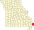
Whiting, Missouri

Last updated
Whiting, Missouri
Coordinates: 36°47′18″N89°22′32″W / 36.78833°N 89.37556°W / 36.78833; -89.37556 Coordinates: 36°47′18″N89°22′32″W / 36.78833°N 89.37556°W / 36.78833; -89.37556
Country Flag of the United States.svg  United States
State Flag of Missouri.svg  Missouri
County Mississippi
Area
[1]
  Total0.26 sq mi (0.68 km2)
  Land0.26 sq mi (0.68 km2)
  Water0.00 sq mi (0.00 km2)
Elevation
[2]
308 ft (94 m)
Population
 (2020)
  Total155
  Density593.87/sq mi (229.36/km2)
FIPS code 29-79684
GNIS feature ID2806415 [2]

Whiting is an unincorporated community in Mississippi County, in the U.S. state of Missouri. [2]

Contents

History

A post office called Whiting was established in 1889, and remained in operation until 1909. [3] The community has the name of Justin R. Whiting, a businessperson in the local lumber industry. [4]

Demographics

Historical population
CensusPop.Note
2020 155
U.S. Decennial Census [5]

Related Research Articles

<span class="mw-page-title-main">Mississippi County, Missouri</span> County in Missouri, United States

Mississippi County is a county located in the Bootheel of the U.S. state of Missouri, with its eastern border formed by the Mississippi River. As of the 2020 census, the population was 12,577. The largest city and county seat is Charleston. The county was officially organized on February 14, 1845, and was named after the Mississippi River.

<span class="mw-page-title-main">Bertrand, Missouri</span> City in Missouri, United States

Bertrand is a city in Mississippi County, Missouri, United States. The population was 718 at the 2020 census.

<span class="mw-page-title-main">Charleston, Missouri</span> City in Missouri, United States

Charleston is a city in Mississippi County, Missouri, United States. The population was 5,056 at the 2020 census. It is the county seat of Mississippi County. It is a home to a local correctional facility.

<span class="mw-page-title-main">Steele, Missouri</span> City in Missouri, United States

Steele is a city in southern Pemiscot County in the Missouri Bootheel of southeastern Missouri, United States. The population was 1,853 at the 2020 census.

<span class="mw-page-title-main">East Prairie, Missouri</span> City in Missouri, United States

East Prairie is a city in Mississippi County, Missouri, United States. The population was 2,943 at the 2020 census.

<span class="mw-page-title-main">Saverton, Missouri</span> Unincorporated community in Missouri, United States

Saverton is an unincorporated community in eastern Ralls County, Missouri, United States. It is located on the Mississippi River, approximately ten miles southeast of Hannibal. Saverton is part of the Hannibal Micropolitan Statistical Area.

<span class="mw-page-title-main">Dorena, Missouri</span> Unincorporated community in Missouri, United States

Dorena is an unincorporated community in southeastern Mississippi County, Missouri, United States. Route 77 and Route 102 intersect here, approximately thirteen miles southeast of East Prairie. Dorena lends its name to the nearby Dorena-Hickman Ferry, which connects Route 77 with the Kentucky side of the Mississippi River.

Aurora Springs is an unincorporated community and census-designated place in northern Miller County, in the U.S. state of Missouri. The community is located on Saline Creek, just south of Eldon and west of U.S. Route 54.

Belmont is an extinct town in Mississippi County, on the eastern border of the U.S. state of Missouri at the Mississippi River. The GNIS classifies it as a populated place under the name "Belmont Landing".

Buckeye is an unincorporated community in Mississippi County in the U.S. state of Missouri.

Crosno is an extinct town in Mississippi County, in the U.S. state of Missouri. The GNIS classifies it as a populated place.

Dogwood is an unincorporated community in Mississippi County, in the U.S. state of Missouri.

Fuget is an extinct town in Mississippi County, in the U.S. state of Missouri. The GNIS classifies it as a populated place.

Greenfield is an extinct town in Mississippi County, in the U.S. state of Missouri. The GNIS classifies it as a populated place.

Henson is an unincorporated community in Mississippi County, in the U.S. state of Missouri.

Rushs Ridge is an extinct town in Mississippi County, in the U.S. state of Missouri. The GNIS classifies it as a populated place.

Samos is an unincorporated community in Mississippi County, in the U.S. state of Missouri. The community was at the intersection of County roads 326 and 321 approximately 4.5 miles southeast of Charleston and 3.5 miles southwest of Wyatt. It was on the St. Louis Southwestern Railroad line.

Three States is an extinct town in Mississippi County, in the U.S. state of Missouri. The GNIS classifies it as a populated place.

Cottonwood Point is a census-designated place in Pemiscot County, in the U.S. state of Missouri. The community is on the west bank of the Mississippi River with Heloise, Tennessee lying one mile across the river to the southeast.

Tyler is an unincorporated community in Pemiscot County, in the U.S. state of Missouri. The community is on County Road 570 approximately four miles east-southeast of Cooter. The Mississippi River is 1.5 miles to the east. Cottonwood Point on the bank of the Mississippi is three miles to the northeast.

References

  1. "ArcGIS REST Services Directory". United States Census Bureau. Retrieved September 5, 2022.
  2. 1 2 3 U.S. Geological Survey Geographic Names Information System: Whiting, Missouri
  3. "Post Offices". Jim Forte Postal History. Retrieved 6 November 2016.
  4. "Mississippi County Place Names, 1928–1945". The State Historical Society of Missouri. Archived from the original on June 24, 2016. Retrieved November 6, 2016.
  5. "Census of Population and Housing". Census.gov. Retrieved June 4, 2016.