
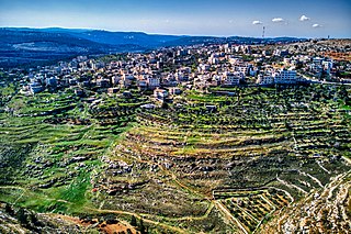
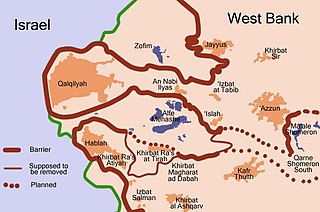
Qalqilya or Qalqiliya is a Palestinian city in the West Bank which serves as the administrative center of the Qalqilya Governorate. In the 2017 census, the city had a population of 51,683. Qalqilya is surrounded by the Israeli West Bank wall, with a narrow gap in the east controlled by the Israeli military and a tunnel to the Palestinian town of Hableh. Qalqilya is under the administration of the Palestinian National Authority, while remaining under Israeli military occupation.
Nahalin, also spelled Nahaleen, is a Palestinian village located in the Bethlehem Governorate of the State of Palestine, to the southwest of Bethlehem in the West Bank. The village was well known for beekeeping and tens of beehives still exist in Nahalin today. The village is also known locally for its almond and olive trees, vineyards, parsley and vegetables, namely onions and beans. The built-up area of Nahalin consists of roughly 730 dunams, 20 of which make up the old center of the village. The village had a population of 8,741 in 2017.

Abu Dis or Abu Deis is a Palestinian village in the West Bank, in the Jerusalem Governorate of the State of Palestine, bordering Jerusalem. Since the 1995 Oslo II Accord, Abu Dis land has been mostly part of "Area B", under Israeli military control and Palestinian civic control. According to the Palestinian Central Bureau of Statistics (PCBS) census, Abu Dis had a population of 12,251 in 2017.
Jayyus is a Palestinian village near the west border of the West Bank, close to Qalqilya. It is a farming community. According to the Palestinian Central Bureau of Statistics, the village had a population of 3,478 inhabitants in 2017.

Migdalim is an Israeli settlement in the West Bank. Located 45 kilometres east of Tel Aviv on road 505 and adjacent to the Palestinian village of Qusra, it is organised as a community settlement and falls under the jurisdiction of Shomron Regional Council. In 2022 it had a population of 592.

Ma'ale Shomron is an Israeli settlement in the northern West Bank. Located about 300 metres above sea level, it is organised as a community settlement and falls under the jurisdiction of Shomron Regional Council. In 2019 it had a population of 996.

Ateret is an Israeli settlement organized as a community settlement in the West Bank. Located in the municipal jurisdiction of the Mateh Binyamin Regional Council, it is located on a hilltop, at an elevation of 760 metres, occupying land confiscated by Israel from three nearby Palestinian villages: Ajjul, 'Atara, and Umm Safa. In 2022 it had a population of 891.

Shavei Shomron is an Israeli settlement in the northern West Bank. Built on lands confiscated from the neighboring Palestinian villages of An-Naqura and Deir Sharaf, it is located to the west of Nablus, on the road to Tulkarm. It is organised as a community settlement and falls under the jurisdiction of Shomron Regional Council. In 2022 it had a population of 1,083, mostly religious Zionist and Modern Orthodox Jews. Its municipal jurisdiction is 664 dunams, of which 272 dunams are built up.

Beit Horon is a communal Israeli settlement in the West Bank. Bordering Route 443 between Modi'in and Jerusalem, the biblical pass of Beit Horon, after which it is named, it falls under the jurisdiction of Mateh Binyamin Regional Council. In 2022 it had a population of 1,442.
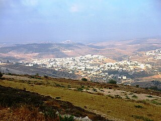
Hajjah is a Palestinian village in the northern West Bank, located eighteen kilometers west of Nablus in the Qalqilya Governorate of the State of Palestine. According to the Palestinian Central Bureau of Statistics, the town had a population of 2,659 inhabitants in 2017.
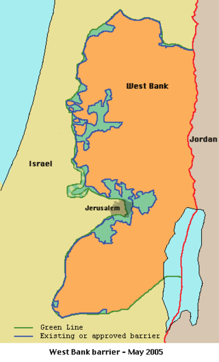
Seam Zone is a term used to refer to a land area in the Israeli-occupied West Bank located east of the Green Line and west of Israel's separation barrier, populated largely by Israelis in settlements such as Alfei Menashe, Ariel, Beit Arye, Modi'in Illit, Giv'at Ze'ev, Ma'ale Adumim, Beitar Illit and Efrat.
Tzufim, or Tzufin, is an Israeli settlement in the West Bank. Located north of Alfei Menashe and Qalqilyah and northeast of Kfar Saba, it is organised as a community settlement and falls under the jurisdiction of Shomron Regional Council. In 2022 it had a population of 2,553.

Kafr Thulth is a Palestinian town located on high, flat land south of Azzoun, 28 kilometers (17 mi) south of Tulkarm in the Qalqilya Governorate. The average elevation is 270 meters (890 ft) above sea level. According to the Palestinian Central Bureau of Statistics, the town's population was 5,606 in the 2017 census.
Beit Iksa is a Palestinian village in the Jerusalem Governorate, located northwest of Jerusalem in the West Bank.

'Anata is a Palestinian town in the Jerusalem Governorate of the State of Palestine, in the central West Bank, located four kilometers northeast of Jerusalem's Old City. According to the Palestinian Central Bureau of Statistics, 'Anata had a population of 16,919 in 2017. Its total land area is 30,603 dunams, of which over half now lies within the Israeli Jerusalem municipality and 1,654 is Palestinian built-up area. Since 1967, 'Anata has been occupied by Israel. Together with Shu'afat refugee camp, the village is almost surrounded by the Israeli West Bank barrier, cutting it off from Jerusalem and surrounding villages except for a checkpoint in the west and a road in the north-east that gives access to the rest of the West Bank.
Ras Atiya is a Palestinian town in the Qalqilya Governorate in the western area of the West Bank, located 27 km south of Tulkarm and 11 km south of Qalqiliya. According to the Palestinian Central Bureau of Statistics, the village had a population of 2,129 inhabitants in 2017.

Nabi Ilyas is a Palestinian village in the Qalqilya Governorate of the State of Palestine, in the western West Bank, located two kilometers east of Qalqilya. According to the Palestinian Central Bureau of Statistics, an Nabi Ilyas had a population of 1,399 inhabitants in 2017. 25.6% of the population of an Nabi Ilyas were refugees in 1997.

Halamish, also known as Neveh Tzuf, is an Israeli settlement in the West Bank, located in the southwestern Samarian hills to the north of Ramallah, 10.7 kilometers east of the Green line. The Orthodox Jewish community was established in 1977. It is organised as a community settlement and falls under the jurisdiction of Mateh Binyamin Regional Council. In 2022 it had a population of 1,590. On a hill within the settlement is Hovlata, an archeological site dating to the Hasmonean period.

Azzun is a Palestinian town in Qalqilya Governorate in the northern West Bank, located 9 kilometers east of Qalqilya and 24 kilometers south of Tulkarm.
At-Tira is a Palestinian village in the Ramallah and al-Bireh Governorate in the northern West Bank.


