Alsdorf (German pronunciation:[ˈalsdɔʁf]ⓘ) is a municipality in the district of Aachen, in North Rhine-Westphalia, Germany. Until the 21st century Alsdorf was a mining area, but now many service companies have established themselves in Alsdorf. Alsdorf has an indoor arena, a cinema, a mining museum and a zoo. One of Alsdorf's famous sights is the old Castle.
Today´s city of Alsdorf is a complex mixture of very different ingredients. A part of today's city was a part of the Duchy of Limburg (later united with Duchy of Brabant); and one part belonged to the territory of the Duchy of Jülich.
In addition, Alsdorf consists of ancient settlements whose history dates back to medieval times, as well as settlements that arose because of the long coal mining tradition in Alsdorf. The old settlements are: Alsdorf, Bettendorf, Hoengen, Ofden, Schaufenberg, Warden and Zopp.
The name Alsdorf was mentioned for the first time in a document of the Catholic Church in the year 1191. But it might be much older than 800 years. During its history, Alsdorf changed its affiliation a few times. Along with the duchy of Brabant and the duchy of Limburg, it also belonged to the duchy of Burgundy (1430) and fell to the Habsburgs in 1482. Then in 1555, it became part of the Spanish Netherlands under the Spanish Habsburgs. In 1714, it was returned to the Austrian Habsburgs until the French invasion of 1794. Pursuant to a judgement of the 1815 Congress of Vienna, Alsdorf was awarded to Prussia.
Until the middle of the 19th century, farming was the main industry. Only Alsdorf (approximately 1,200) and Hoengen (about 1,400) had more than 1,000 inhabitants. Population in the greater area of today's Alsdorf totalled 4,000 people.
Today the population is more than ten times larger as a result of mining, which came to Alsdorf in the middle of the 19th century. The mining industry needed many workers. First, it was possible to cover the demand with local workers but as the mine grew, the need for workers grew. To be an attractive employer, the mine company built new houses to offer its employees good working conditions. Between 1860 and 1960, a few bigger and smaller villages were founded. These villages are: Begau, Blumenrath, Broicher Siedlung, Busch, Kellersberg, Mariadorf, Neuweiler, Ofden, Ost and Zopp. In 1932, the villages Kellerberg, Ofden, Schaufenberg, and Neuweiler were incorporated and the population grew from 11,500 to 19,711.
The great tragedy on October 21, 1930, demonstrated the danger of mine work. In the Anna II Mine, 270 men and one woman were killed. It was the second largest mining accident in Germany history.
The Maria Mine closed in September 1962, and the last mine in Alsdorf shut down in 1992. Since this time, Alsdorf has successfully changed its image away from a coal city to a modern business location. A few business parks have been founded, where a lot of companies have located.
Districts
Alsdorf is divided in 17 districts:
Alsdorf-Mitte
Begau
Bettendorf
Blumenrath
Broicher Siedlung
Busch
Duffesheide
Hoengen
Kellersberg
Mariadorf
Neuweiler
Ofden
Schaufenberg
Schleibach
Siedlung Ost
Warden
Zopp
Politics
Council
The situation in Alsdorf's council after the last election[3] in 2020:
Alsdorf Civic Center (previously "Euro-Musical-Hall"). Musicals like Gaudí and Just One World were played there.
Alsdorf Zoo
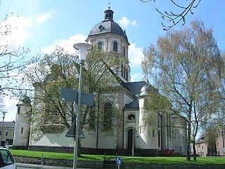
Water tower "CineTower Alsdorf"
Blumenrath
Blumenrather cross
Secondary modern school Johann Heinrich Pestalozzi
Blumenrath estate
Kellersberg
Kellersberger mill
Mariadorf
previously station Maria mine
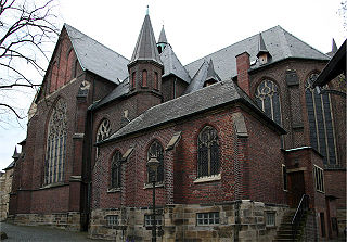
Church St. Mariae Empfängnis
Middle school Marienschule
Memorial
Old major house
Bus station
Broicher mill
Hoengen
Milestone
Economy and infrastructure
For over a century, coal mining was the heart of Alsdorf's economy. Coal production started in 1849, when the Maria Mine opened in Hoengen. In 1853, production started in the Anna coal mine of Alsdorf. This was the reason for an increase in production and workforce, this was particularly measurable in mine Anna but not in mine Maria, which was closed by September 1962. Unfortunately, the coal crisis has not spared Alsdorf, and the last mine was closed in 1992.
Alsdorf's biggest employer was the Cinram GmbH, with about 2,000[4] employees in district of Schaufenberg. This company produces up to 2 million DVDs, Blu-rays and CDs daily, exported throughout Europe. The company was founded in 1975 by Warner Music and sold in 2003 to the Canadian stock corporation Cinram International. Customers are well-known record labels and media companies like Warner Music, Twentieth Century Fox and Universal Pictures. In 2017 close down its european manufacturing plant at Alsdorf.[5]
Besides acquired companies, which either used the closeness to RWTH Aachen University or which saw the favourable location near the borders to Belgium and the Netherlands as advantage.
In June 2022 it was announced that in the first quarter of 2023 Continental the German multinational automotive parts manufacturing company would produce fuel tanks at Alsdorf. A new factory is built by Continental Fuel Storage Systems GmbH. [6]
Traffic
Alsdorf is located in the heart of Europe, within approximately 200km of the most important economic centers of the European Union. The town lies in the center of the tri-border region of Germany / Netherlands / Belgium.
Furthermore, Alsdorf provides a very good bus system. Every part of Alsdorf or Aachen is served by the buses of ASEAG, the local bus company.
Since 2005, Alsdorf is connected to the Euregiobahn a regional train system. The railway network has extended steadily; hence you can reach Mariadorf since 2011 by regional train.
Ludwig Schaffrath (1924–2011), sculptor and painter, honorary citizen of Alsdorf
Hans Berger (born 1938), honorary professor at the University of Applied Sciences Georg Agricola, Chairman of the Mining and Energy from 1991 to 1997, SPD member of the Bundestag from 1990 to 1998
Helmut Brandt (born 1950), politician (CDU), Member of Bundestag
Hans-Peter Lehnhoff (born 1963), former football player, including 1. FC Köln, Bayer 04 Leverkusen
Ralf Souquet (born 1968), billiard champion and gold medalist World Games
North Rhine-Westphalia or North-Rhine/Westphalia, commonly shortened to NRW, is a state (Land) in Western Germany. With more than 18 million inhabitants, it is the most populous state in Germany. Apart from the city-states, it is also the most densely populated state in Germany. Covering an area of 34,084 square kilometres (13,160 sq mi), it is the fourth-largest German state by size.
Ennepetal is a town in the district of Ennepe-Ruhr-Kreis, in North Rhine-Westphalia, Germany. It was created in 1949 out of the former municipalities Milspe and Voerde. It was named after the river Ennepe, which flows through the municipality.
Eschweiler is a municipality in the district of Aachen in North Rhine-Westphalia in Germany on the river Inde, near the German-Belgian-Dutch border, and about 15 kilometres (9 mi) east of Aachen and 50 kilometres (31 mi) west of Cologne.
Heinsberg is a town in North Rhine-Westphalia, Germany. It is the seat of the district Heinsberg. It is situated near the border with the Netherlands, on the river Wurm, approx. 20 km north-east of Sittard and 30 km south-west of Mönchengladbach.
Herzogenrath is a municipality in the district of Aachen in the German state of North Rhine-Westphalia. It borders the Dutch town of Kerkrade, the national border in one section running along the middle of a main road and even directly through the centre of the cross-border Eurode office complex.
Zülpich is a town in North Rhine-Westphalia, Germany between Aachen and Bonn. It belongs to the district of Euskirchen.
Würselen is a town in the borough of Aachen, in North Rhine-Westphalia, Germany.
Goch is a town in the Kleve district of North Rhine-Westphalia, Germany, close to the border with the Netherlands, 12 km (7 mi) south of Kleve and 27 km (17 mi) southeast of Nijmegen.
Übach-Palenberg is a town in the Heinsberg district of North Rhine-Westphalia, Germany. It was formed by the merger of two villages, Palenberg and Übach.
Geldern is a city in the federal German state of North Rhine-Westphalia. It is part of the district of Kleve, which is part of the Düsseldorf administrative region. The nearby Dutch province of Gelderland is named after this city.
Castrop-Rauxel, often simply referred to as Castrop by locals, is a former coal mining city in the eastern part of the Ruhr Area within the state of North Rhine-Westphalia in Germany.
Waltrop (German pronunciation:[ˈvaltʁɔp] is a town in the district of Recklinghausen, in North Rhine-Westphalia, Germany. It is situated on the Datteln-Hamm Canal, approximately 15 km east of Recklinghausen and 15 km north-west of Dortmund.
Baesweiler is a municipality in the district of Aachen, North Rhine-Westphalia, Germany.
Gescher is a municipality in the district of Borken, in North Rhine-Westphalia, Germany. It is located near the border with the Netherlands. It is most often known for its bell work, and it includes a Museum of Bells.
Niederzier is a municipality in the district of Düren in the state of North Rhine-Westphalia, Germany. It is located approximately 10 km north of Düren, and 10 km south-east of Jülich.
Hückelhoven is a town in the district of Heinsberg, in North Rhine-Westphalia, Germany. It is situated on the river Rur, approx. 10 km east of Heinsberg, 20 km south-west of Mönchengladbach and approximately 15 km from the border with the Netherlands. Hückelhoven owes its development from village to town to the coal mining industry; the Sophia-Jacoba colliery was opened in 1914. This colliery was closed in 1997.
Lohmar is a town in the Rhein-Sieg district, in North Rhine-Westphalia, Germany.
Neukirchen-Vluyn is a town in the district of Wesel, in North Rhine-Westphalia, Germany. It is situated approximately 5 km west of Moers, and 15 km north of Krefeld.
Burbach is a municipality in the Siegen-Wittgenstein district, in North Rhine-Westphalia, Germany.
Hans Berger was a German trade unionist and politician of the Social Democratic Party (SPD). From 1990 to 1998, he served in the Bundestag and served as the chairman of the Union of Mining and Energy (IGBE). Most recently, he was a member of the IG Bergbau, Chemie, Energie (IGBCE).
This page is based on this Wikipedia article Text is available under the CC BY-SA 4.0 license; additional terms may apply. Images, videos and audio are available under their respective licenses.