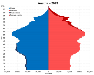
Demographic features of the population of Austria include population density, ethnicity, education level, health of the populace, economic status, religious affiliations and other aspects of the population.
Upper Austria is one of the nine states or Länder of Austria. Its capital is Linz. Upper Austria borders Germany and the Czech Republic, as well as the other Austrian states of Lower Austria, Styria, and Salzburg. With an area of 11,982 km2 (4,626 sq mi) and 1.49 million inhabitants, Upper Austria is the fourth-largest Austrian state by land area and the third-largest by population.

Lower Austria is one of the nine states of Austria, located in the northeastern corner of the country. Major cities are Amstetten, Krems an der Donau, Wiener Neustadt and Sankt Pölten, which has been the capital of Lower Austria since 1986, replacing Vienna, which became a separate state in 1921. With a land area of 19,186 km2 (7,408 sq mi) and a population of 1.7 million people, Lower Austria is the largest and second-most-populous state in Austria.

Horn is a small town in the Waldviertel in Lower Austria, Austria and the capital of the district of the same name.

Styria is an Austrian state in the southeast of the country. With an area of approximately 16,399 km2 (6,332 sq mi), Styria is Austria's second largest state, after Lower Austria. It is bordered to the south by Slovenia, and clockwise, from the southwest, by the other Austrian states of Carinthia, Salzburg, Upper Austria, Lower Austria, and Burgenland. The state's capital is Graz, the second largest city in Austria after only Vienna.

Hochfilzen is a town and municipality in the Kitzbühel district of the Austrian state of Tyrol. It is located in the Pillersee valley 5 km east of Fieberbrunn. Population was 1,147 in 2016.
Sportklub Rapid, commonly known as Rapid Wien or Rapid Vienna in English, is an Austrian professional football club playing in the country's capital city of Vienna. Rapid has won the most Austrian championship titles (32), including the first title in the season 1911–12, as well as a German championship in 1941 during Nazi rule, although its cross-city arch rival FK Austria Vienna has won more combined league and cup titles. Rapid twice reached the final of the European Cup Winners' Cup in 1985 and 1996, losing on both occasions.
The Official Municipality Key, formerly also known as the Official Municipality Characteristic Number or Municipality Code Number, is a number sequence for the identification of politically independent municipalities or unincorporated areas. Other classifications for the identification of areas include postal codes, NUTS codes or FIPS codes.

Kapfenberg, with 22,182 inhabitants in 2023, is the third largest city in Styria, Austria, and lies in the valley of the Mürz near the town of Bruck an der Mur. The town's landmark is Burg Oberkapfenberg. Every year in June, the Ritterfest takes place at the castle, which is one of the largest events of its kind in Austria.
Spielberg is a city located in the Bezirk Murtal in Styria, Austria.

Religion in Austria is predominantly Christianity, adhered to by 68.2% of the country's population according to the 2021 national survey conducted by Statistics Austria. Among Christians, 80.9% were Catholics, 7.2% were Orthodox Christians, 5.6% were Protestants, while the remaining 6.2% were other Christians, belonging to other denominations of the religion or not affiliated to any denomination. In the same census, 8.3% of the Austrians declared that their religion was Islam, 1.2% declared to believe in other non-Christian religions, and 22.4% declared they did not belong to any religion, denomination or religious community.
The Austria Davis Cup team represents Austria in the Davis Cup and is governed by the Austrian Tennis Federation. In 2010, Austria was re-promoted to the World Group after being relegated to the Europa/Africa Zone Group I only one year earlier. In 2012, Austria advanced to the World Group quarterfinals for the first time since 1995, eventually losing against Spain.

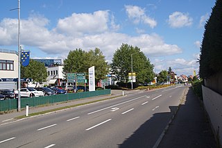
Maria Enzersdorf is a small city in the district of Mödling in the Austrian state of Lower Austria.
Altach is a municipality in the district of Feldkirch, in the westernmost Austrian state of Vorarlberg.

Ottensheim is a municipality in the district of Urfahr-Umgebung in the Austrian state of Upper Austria. At its rowing venue, Regattastrecke Ottensheim, it has hosted numerous international rowing competitions, including various World Championships, World U23 Championships, World Junior Championships, and World Cups.

Bad Waltersdorf is a spa town in the district of Hartberg-Fürstenfeld in Styria, Austria.

Austria, formally the Republic of Austria, is a landlocked country in Central Europe, lying in the Eastern Alps. It is a federation of nine states, one of which is the capital, Vienna, the most populous city and state. Austria is bordered by Germany to the northwest, the Czech Republic to the north, Slovakia to the northeast, Hungary to the east, Slovenia and Italy to the south, and Switzerland and Liechtenstein to the west. The landlocked country occupies an area of 83,879 km2 (32,386 sq mi) and has a population of around 9 million.
The Austria national under-19 football team is the national under-19 football team of Austria and is controlled by the Austrian Football Association.
Austrian Canadians are Canadian citizens who are of Austrian ancestry or Austrian-born people who reside in Canada. According to the 2021 Census, there were 189,535 Canadians who claimed either full or partial Austrian ancestry.


