A request that this article title be changed to Grafenbach-St. Valentin is under discussion . Please do not move this article until the discussion is closed. |
Grafenbach-St. Valentin | |
|---|---|
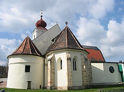 The parish church | |
 Coat of arms | |
 Grafenbach-St. Valentin Location within Austria | |
| Coordinates: 47°41′N16°0′E / 47.683°N 16.000°E | |
| Country | Austria |
| State | Lower Austria |
| District | Neunkirchen |
| Government | |
| • Mayor | Sylivia Kögler (SPÖ) |
| Area | |
• Total | 13.9 km2 (5.4 sq mi) |
| Elevation | 430 m (1,410 ft) |
| Population (2018-01-01) [2] | |
• Total | 2,264 |
| • Density | 163/km2 (422/sq mi) |
| Time zone | UTC+1 (CET) |
| • Summer (DST) | UTC+2 (CEST) |
| Postal code | 2632 |
| Area code | 02630 |
| Vehicle registration | NK |
| Website | www.grafenbach.at |
Grafenbach-Sankt Valentin is a town in the district of Neunkirchen in the Austrian state of Lower Austria.