Watonwan County is a county in the U.S. state of Minnesota. As of the 2010 United States Census, the population was 11,211. Its county seat is St. James.

Red Lake County is a county in the Northwestern part of the U.S. state of Minnesota. As of the 2010 United States Census, the population was 4,089, making it the third-least populous county in Minnesota. Its county seat is Red Lake Falls.

Nicollet County is a county in the U.S. state of Minnesota. As of the 2010 census, the population was 32,727. Its county seat is St. Peter.

Goodhue County is a county in the U.S. state of Minnesota. As of the 2010 census, the population was 46,183. Its county seat is Red Wing. Nearly all of Prairie Island Indian Community is within the county.

Crow Wing County is a county in the East Central part of the U.S. state of Minnesota. As of the 2010 United States Census, the population was 62,500. Its county seat is Brainerd. The county was formed in 1857, and was organized in 1870.

Cottonwood County is a county in the U.S. state of Minnesota. As of the 2010 United States Census, the population was 11,687. Its county seat is Windom.

Chisago County is a county in the U.S. state of Minnesota. As of the 2010 United States Census, the population was 53,887. Its county seat is Center City.

Cass County is a county in the central part of the U.S. state of Minnesota. As of the 2010 United States Census, the population was 28,567. Its county seat is Walker. The county was formed in 1851, and was organized in 1897.

Carlton County is a county in the State of Minnesota, formed in 1857. As of the 2010 United States Census, the population was 35,386. Its county seat is Carlton. Part of the Fond du Lac Indian Reservation lies in northeastern Carlton County.

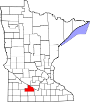
Brown County is a county in the U.S. state of Minnesota. As of the 2010 United States Census, the population was 25,893. Its county seat is New Ulm. The county was formed in 1855 and organized in 1856.

Big Stone County is a county in the U.S. state of Minnesota. As of the 2010 United States Census, the population was 5,269. Its county seat is Ortonville.

Beltrami County is a county in the northern part of the U.S. state of Minnesota. As of the 2010 United States Census, the population was 44,442. Its county seat is Bemidji. The county's name comes from Italian adventurer Giacomo Beltrami from Bergamo, who explored the area in 1825. The county was created in 1866 and organized in 1896.

Bashaw Township is a township in Brown County, Minnesota, United States. The population was 243 as of the 2010 census.

Henderson is a city in Sibley County, Minnesota, United States. The population in was 886 at the 2010 census.

Monticello is a city next to the Mississippi River in Wright County, Minnesota, United States. The population was 12,759 at the 2010 census.
Bde Maka Ska is the largest lake in Minneapolis, Minnesota, United States, and part of the city's Chain of Lakes. Surrounded by city park land and circled by bike and walking trails, it is popular for many outdoor activities. The lake has an area of 401 acres (1.62 km2) and a maximum depth of 87 feet (27 m).
Bachelor Lake is a lake in Brown County, Minnesota in the northeastern part of Stark township. Covering 79.80 acres, it is an officially protected water of the State of Minnesota. The lake is within the Cottonwood River Major Watershed. The lake’s elevation is 1,004 feet (306 m), and it is zoned as a shoreland area which is regulated as a shoreland management water.

Manganese is a ghost town and former mining community in the U.S. state of Minnesota that was inhabited between 1912 and 1960. It was built in Crow Wing County on the Cuyuna Iron Range in sections 23 and 28 of Wolford Township, about 2 miles (3.2 km) north of Trommald, Minnesota. After its formal dissolution, Manganese was absorbed by Wolford Township; the former town site is located between Coles Lake and Flynn Lake. First appearing in the U.S. Census of 1920 with an already dwindling population of 183, the village was abandoned by 1960.
Clear Lake is a lake in North Cottonwood, Township, Brown County, Minnesota, in the United States. It is a protected public lake.