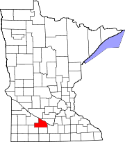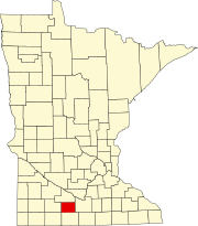
Watonwan County is a county in the U.S. state of Minnesota. As of the 2020 census, the population was 11,253. Its county seat is St. James.
Ramsey County is a county located in the U.S. state of Minnesota. As of the 2020 census, the population was 552,352, making it the second-most populous county in Minnesota. Its county seat and largest city is Saint Paul, the state capital and the twin city of Minneapolis. The county was founded in 1849 and is named for Alexander Ramsey, the first governor of the Minnesota Territory.

Cottonwood County is a county in the U.S. state of Minnesota. As of the 2020 census, the population was 11,517. Its county seat is Windom.

Brown County is a county in the U.S. state of Minnesota. As of the 2020 census, the population was 25,912. Its county seat is New Ulm. The county was formed in 1855 and organized in 1856.

Jeffers is a city in Amboy Township, Cottonwood County, Minnesota, United States. The population was 369 at the 2010 census.

Mountain Lake Township is a township located in Cottonwood County, Minnesota, United States. According to the 2010 census, the population was 384. The township was organized in 1871.

Marine on St. Croix or Marine on Saint Croix is a city in Washington County, Minnesota, United States. The population was 689 at the 2010 census. It was founded in 1839 as Marine Mills. The city was the site of the first commercial sawmill on the St. Croix River. A substantial portion of the city is listed as a historic district on the National Register of Historic Places and by the state of Minnesota.
Madelia is a city in Watonwan County, Minnesota, United States, along the Watonwan River. The population was 2,308 at the 2010 census.
St. James or Saint James is a city in and the county seat of Watonwan County, Minnesota, United States. The population was 4,793 at the 2020 census.

The Jeffers Petroglyphs site is an outcrop in southwestern Minnesota with pre-contact Native American petroglyphs. The petroglyphs are pecked into rock of the Red Rock Ridge, a 23-mile (37 km)-long Sioux quartzite outcrop that extends from Watonwan County, Minnesota to Brown County, Minnesota. The exposed surface is approximately 150 by 650 feet and surrounded by virgin prairie. "The site lies in an area inhabited in the early historic period by the Dakota Indians, and both the style and form of some of the carvings are identical with motifs that appear on Dakota hide paintings and their quill designs and beadwork. Others are foreign to this Plains Indian tradition and seem to be much earlier in origin." Several old wagon trail ruts traverse the site, one of which is believed to be the old stage coach route from New Ulm, Minnesota to Sioux Falls, South Dakota.

This is a list of sites in Minnesota which are included in the National Register of Historic Places. There are more than 1,700 properties and historic districts listed on the NRHP; each of Minnesota's 87 counties has at least 2 listings. Twenty-two sites are also National Historic Landmarks.

Reads Landing is an unincorporated community in Pepin Township, Wabasha County, Minnesota, United States, along the Mississippi River. The community is located between Lake City and Wabasha along U.S. Highway 61 at the junction with Wabasha County Road 77 and near Wabasha, Lake City, Camp Lacupolis, and Maple Springs. Reads Landing is located within section 24 of Pepin Township.
Delft is an unincorporated community located in Carson Township, Cottonwood County, Minnesota, United States.

The Sibley Historic Site is the site of Henry Hastings Sibley's home, who was the regional manager of the American Fur Company and Minnesota's first governor. It is one of the 26 historical sites that are operated by the Minnesota Historical Society. Located in what is now the city of Mendota, the site consists of four limestone buildings and a large lawn area. Three of the buildings are open for touring, including a fur company cold store from 1843 and the 1840 home of fur trader and hotelier Jean-Baptiste Faribault.

The Godahl Store is a historic consumers' co-operative general store established in the unincorporated community of Godahl in 1894. It was listed on the National Register of Historic Places as the Nelson and Albin Cooperative Mercantile Association Store in 1987 for its local significance to commerce. The store was in business through 2016.
St. Columba Mission was an Ojibwe community on Gull Lake in Crow Wing County, Minnesota, United States, about 11 miles (18 km) north of Fort Ripley. It centered on the first Native American Christian church in the United States west of the Mississippi River, founded in 1852 by the Episcopal missionary James Lloyd Breck and Enmegahbowh, who served as deacon. The squared log church was consecrated in 1853 by Bishop Jackson Kemper.
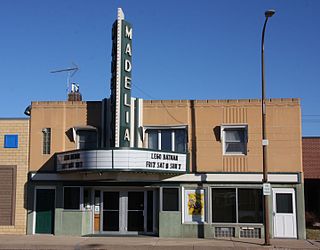
Flanders' Block is a historic commercial building in Madelia, Minnesota, United States, built in 1872. From 1872 to 1878 it served as the county seat building of Watonwan County, housing the courthouse, offices, and jail. Flanders' Block was listed on the National Register of Historic Places in 1984 for having local significance in the theme of politics/government. It was nominated for its associations with the early development of Watonwan County's government.
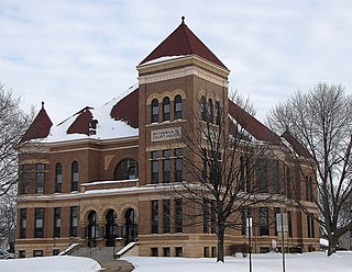
The Watonwan County Courthouse in St. James, Minnesota, United States, is the seat of government for Watonwan County, in continual use since it was completed in 1896. It was listed on the National Register of Historic Places in 1987 for having state-level significance in the themes of architecture and politics/government. It was nominated for its exemplary Romanesque Revival architecture, its status as one of Minnesota's remaining monumental Victorian courthouses and as a local landmark, and its longstanding service as county seat.
Tenmile Corner - so named because it is located 10 miles due east of St. James, on state highway 60 - is an unincorporated community in Fieldon Township, Watonwan County, Minnesota, United States, located between Madelia and St. James on the intersection of highway 60 and highway 15. Its elevation is 1,030 feet.
K31KV-D, virtual channel 16, known on-air as CTV, is a low-powered television station licensed to St. James, Minnesota, United States.