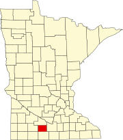
Watonwan County is a county in the U.S. state of Minnesota. As of the 2010 United States Census, the population was 11,211. Its county seat is St. James.

Ceresco Township is a township in Blue Earth County, Minnesota, United States. The population was 255 as of the 2000 census.
Lincoln Township is a township in Blue Earth County, Minnesota, United States. The population was 227 as of the 2000 census.
Pleasant Mound Township is a township in Blue Earth County, Minnesota, United States. The population was 235 as of the 2000 census.
Albin Township is a township in Brown County, Minnesota, United States. The population was 329 at the 2000 census. Albin Township was organized in 1870.
Lake Hanska Township is a township in Brown County, Minnesota, United States. The population was 322 as of the 2000 census. Lake Hanska Township was organized in 1870.
Linden Township is a township in Brown County, Minnesota, United States. The population was 343 as of the 2000 census.
Mulligan Township is a township in Brown County, Minnesota, United States. The population was 245 as of the 2000 census. Mulligan Township was organized in 1871.
Riverdale Township is a township in Watonwan County, Minnesota, United States. The population was 338 at the 2000 census.
South Branch Township is a township in Watonwan County, Minnesota, United States. The population was 303 at the 2000 census.

The Blue Earth River is a tributary of the Minnesota River, 108 miles (174 km) long, in southern Minnesota in the United States. Two of its headwaters tributaries, the Middle Branch Blue Earth River and the West Branch Blue Earth River, also flow for short distances in northern Iowa. By volume, it is the Minnesota River's largest tributary, accounting for 46% of the Minnesota's flow at the rivers' confluence in Mankato. Via the Minnesota River, the Blue Earth River is part of the watershed of the Mississippi River, draining an area of 3,486 square miles (9,029 km²) in an agricultural region. Ninety percent of the river's watershed is in Minnesota. It is a Minnesota Department of Natural Resources designated Water Trail.

The Watonwan River is a tributary of the Blue Earth River, 113 miles (182 km) long, in southern Minnesota in the United States. Via the Blue Earth and Minnesota rivers, it is part of the watershed of the Mississippi River, draining an area of 878 square miles (2,270 km2) in an agricultural region. The Watonwan drains about a quarter of the Blue Earth River's watershed.

Franklin Fowler Ellsworth was a Representative from Minnesota; born in St. James, Watonwan County, Minnesota, July 10, 1879; attended the grade and high schools; enlisted as a private in Company H, Twelfth Regiment, Minnesota Volunteer Infantry, during the Spanish–American War; attended the law department of the University of Minnesota at Minneapolis; was admitted to the bar in 1901 and commenced practice in St. James; city attorney of St. James in 1904 and 1905; prosecuting attorney of Watonwan County 1905–1909; elected as a Republican to the 64th, 65th, and 66th congresses ; was not a candidate for renomination in 1920, having become a gubernatorial candidate; unsuccessful candidate for Governor of Minnesota in 1920 and 1924; moved to Minneapolis, Minnesota, in 1921 and resumed the practice of his profession; died in Minneapolis, December 23, 1942; interment in Lakewood Cemetery.

Godahl is an unincorporated community in Brown and Watonwan counties in the U.S. state of Minnesota.
Perch Creek is a 37.3-mile-long (60.0 km) tributary of the Watonwan River in southern Minnesota, United States. Via the Watonwan, Blue Earth, and Minnesota rivers, it is part of the Mississippi River watershed.
Delft is an unincorporated community located in Cottonwood County, Minnesota in Carson Township.
Bullhead Lake is a lake in Watonwan County, in the U.S. state of Minnesota.
Echols is an unincorporated community in Long Lake Township, Watonwan County, Minnesota, United States.
South Branch is an unincorporated community in South Branch Township, Watonwan County, Minnesota, United States.
Tenmile Corner - so-named because it is located 10 miles straight east of St. James, Minnesota, on state highway 60 - is an unincorporated community in Fieldon Township, Watonwan County, Minnesota, United States, located between Madelia, Minnesota and St. James, Minnesota on the intersection of highway 60 and highway 15. Its elevation is 1,030 feet.