Renville County is a county in the U.S. state of Minnesota. As of the 2020 census the population was 14,723. Its county seat is Olivia.

Meeker County is a county in the U.S. state of Minnesota. As of the 2020 census, the population was 23,400. Its county seat is Litchfield.

Cottonwood County is a county in the U.S. state of Minnesota. As of the 2020 census, the population was 11,517. Its county seat is Windom.

Brown County is a county in the U.S. state of Minnesota. As of the 2020 census, the population was 25,912. Its county seat is New Ulm. The county was formed in 1855 and organized in 1856.
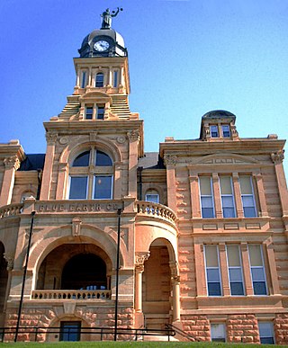
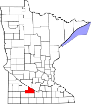
Blue Earth County is a county in the State of Minnesota. As of the 2020 census, the population was 69,112. Its county seat is Mankato. The county is named for the Blue Earth River and for the deposits of blue-green clay once evident along the banks of the Blue Earth River. Blue Earth County is part of the Mankato-North Mankato metropolitan area.

Milford Township is a township in Brown County, Minnesota, United States. The population was 793 as of the 2000 census.
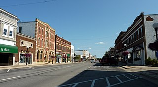
New Ulm is a city in Brown County, Minnesota, United States. The population was 14,120 at the 2020 census. It is the county seat of Brown County. It is located on the triangle of land formed by the confluence of the Minnesota River and the Cottonwood River.
Birch Cooley Township is a township in Renville County, Minnesota, United States. The population was 257 at the 2000 census.

The Lower Sioux Agency, or Redwood Agency, was the federal administrative center for the Lower Sioux Indian Reservation in what became Redwood County, Minnesota, United States. It was the site of the Battle of Lower Sioux Agency on August 18, 1862, the first organized battle of the Dakota War of 1862.

The Battle of Redwood Ferry took place on August 18, 1862, on the first day of the Dakota War of 1862. A United States Army company responding to the Dakota attack at the Lower Sioux Agency from Fort Ridgeley was ambushed and defeated at Redwood Ferry.

Big Eagle was the chief of a band of Mdewakanton Dakota in Minnesota. He played an important role as a military leader in the Dakota War of 1862. Big Eagle surrendered soon after the Battle of Wood Lake and was sentenced to death and imprisoned, but was pardoned by President Abraham Lincoln in 1864. Big Eagle's narrative, "A Sioux Story of the War" was first published in 1894, and is one of the most widely cited first-person accounts of the 1862 war in Minnesota from a Dakota point of view.

Lake Shetek State Park is a state park of Minnesota, United States, on Lake Shetek, which is the largest lake in southwestern Minnesota and the headwaters of the Des Moines River. It is most popular for water recreation and camping. However the park also contains historical resources related to the Dakota War of 1862, including an original log cabin and a monument to 15 white settlers killed there and at nearby Slaughter Slough on August 20, 1862.

Huot is an unincorporated community in Louisville Township, Red Lake County, Minnesota, United States. The name of the community evokes the French-Canadian and Métis history of the Red River Trails and the Pembina settlements of Assiniboia.

The Battles of New Ulm, also known as the New Ulm Massacre, were two battles in August 1862 between Dakota men and European settlers and militia in New Ulm, Minnesota early in the Dakota War of 1862. Dakota forces attacked New Ulm on August 19 and again on August 23, destroying much of the town but failing to fully capture it. After the second attack, New Ulm was evacuated.

The Dakota War of 1862, also known as the Sioux Uprising, the Dakota Uprising, the Sioux Outbreak of 1862, the Dakota Conflict, or Little Crow's War, was an armed conflict between the United States and several eastern bands of Dakota collectively known as the Santee Sioux. It began on August 18, 1862, when the Dakota, who were facing starvation and displacement, attacked white settlements at the Lower Sioux Agency along the Minnesota River valley in southwest Minnesota. The war lasted for five weeks and resulted in the deaths of hundreds of settlers. In the aftermath, the Dakota people were exiled from their homelands, forcibly sent to reservations in the Dakotas and Nebraska, and the State of Minnesota confiscated and sold all their remaining land in the state. The war also ended with the largest mass execution in United States history with the hanging of 38 Dakota men.

The Cottonwood River is a tributary of the Minnesota River, 152 miles (245 km) long, in southwestern Minnesota in the United States. Via the Minnesota River, it is part of the watershed of the Mississippi River, draining an area of 1,313 square miles (3,400 km2) in an agricultural region. The river's name is a translation of the Dakota name for the river, Wáǧa Ožú Wakpá, for the cottonwood tree groves, which are common along prairie rivers. It has also been known historically as the Big Cottonwood River.

Slaughter Slough is a wetland in southwestern Minnesota, United States, so named for being the site of the Lake Shetek Massacre during the Dakota War of 1862. It is located in Murray County east of Lake Shetek. On August 20, 1862, about 40 Dakota men attacked the Euro-American settlers living nearby, killing 15 and taking a dozen women and children captive. 21 settlers escaped or survived the attack and made difficult journeys across the prairie to safety. A band of pacifist Dakota later ransomed the eight surviving captives, who were reunited with their families.

Birch Coulee Battlefield in Renville County, Minnesota, United States, was the site of the Battle of Birch Coulee, the costliest military engagement for U.S. forces during the Dakota War of 1862. It is now a historic site with self-guided trails and markers interpreting the battle from both sides. Birch Coulee was nominated to the National Register of Historic Places for having state-level significance in military history, and was listed in 1973.
The Fort Ridgely and South Pass Wagon Road was a wagon trail that was intended to connect Fort Ridgely in Minnesota Territory with South Pass in the Rocky Mountains of Nebraska Territory. It was designed to link St. Paul with California via the Oregon Trail, however only a portion of the route was completed. The trail was promoted and supervised by William H. Nobles. Appropriations for the trail were authorized by the U.S. Congress on July 22, 1856. It was the first road built in Dakota Territory.

The Battle of Acton was a battle between the United States Army and Little Crow's band of Dakota warriors during the Dakota War of 1862. Following the defeats at Fort Ridgley and New Ulm, Chief Little Crow led an incursion north out of the Minnesota River Valley into central Minnesota. A detachment of the Tenth Minnesota Infantry Regiment commanded by Captain Richard Strout was sent to protect the citizens of Meeker County.