Stark Township, Brown County, Minnesota

Last updated
Stark Township
USA Minnesota location map.svg
Red pog.svg
Stark Township
Location within the state of Minnesota
Usa edcp location map.svg
Red pog.svg
Stark Township
Stark Township (the United States)
Coordinates: 44°14′52″N94°41′18″W / 44.24778°N 94.68833°W / 44.24778; -94.68833 Coordinates: 44°14′52″N94°41′18″W / 44.24778°N 94.68833°W / 44.24778; -94.68833
Country United States
State Minnesota
County Brown
Area
  Total36.1 sq mi (93.6 km2)
  Land35.6 sq mi (92.2 km2)
  Water0.5 sq mi (1.4 km2)
Elevation
1,007 ft (307 m)
Population
 (2000)
  Total384
  Density10.8/sq mi (4.2/km2)
Time zone UTC-6 (Central (CST))
  Summer (DST) UTC-5 (CDT)
FIPS code 27-62518 [1]
GNIS feature ID0665700 [2]

Stark Township is a township in Brown County, Minnesota, United States. The population was 384 as of the 2000 census. [3]

Contents

History

Stark Township was organized in 1868. [4] It was named for August Starck, an early settler and native of Germany. [4]

Geography

According to the United States Census Bureau, the township has a total area of 36.1 square miles (93.6 km2), of which 35.6 square miles (92.2 km2) is land and 0.5 square miles (1.4 km2) (1.50%) is water. The Cottonwood and Little Cottonwood Rivers flow through the township. [5]

Unincorporated communities

Major highway

Lakes

Adjacent townships

Demographics

As of the census [1] of 2000, there were 384 people, 137 households, and 102 families residing in the township. The population density was 10.8 people per square mile (4.2/km2). There were 140 housing units at an average density of 3.9/sq mi (1.5/km2). The racial makeup of the township was 98.44% White, 0.26% African American, 1.30% from other races. Hispanic or Latino of any race were 1.30% of the population.

There were 137 households, out of which 40.1% had children under the age of 18 living with them, 66.4% were married couples living together, 1.5% had a female householder with no husband present, and 25.5% were non-families. 24.1% of all households were made up of individuals, and 12.4% had someone living alone who was 65 years of age or older. The average household size was 2.80 and the average family size was 3.35.

In the township the population was spread out, with 32.0% under the age of 18, 5.2% from 18 to 24, 28.6% from 25 to 44, 21.4% from 45 to 64, and 12.8% who were 65 years of age or older. The median age was 36 years. For every 100 females, there were 108.7 males. For every 100 females age 18 and over, there were 119.3 males.

The median income for a household in the township was $36,705, and the median income for a family was $41,667. Males had a median income of $30,417 versus $26,375 for females. The per capita income for the township was $14,716. About 10.7% of families and 8.3% of the population were below the poverty line, including 9.6% of those under age 18 and none of those age 65 or over.

Related Research Articles

Brown County, Minnesota County in the United States

Brown County is a county in the U.S. state of Minnesota. As of the 2010 United States Census, the population was 25,893. Its county seat is New Ulm. The county was formed in 1855 and organized in 1856.

Cambria Township, Blue Earth County, Minnesota Township in Minnesota, United States

Cambria Township is a township in Blue Earth County, Minnesota, United States. The population was 271 as of the 2000 census.

Cottonwood Township, Brown County, Minnesota Township in Minnesota, United States

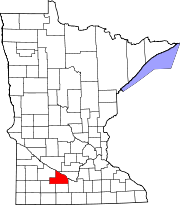
Cottonwood Township is a township in Brown County, Minnesota, United States. The population was 938 as of the 2000 census.

Linden Township, Brown County, Minnesota Township in Minnesota, United States

Linden Township is a township in Brown County, Minnesota, United States. The population was 343 as of the 2000 census.

Milford Township, Brown County, Minnesota Township in Minnesota, United States

Milford Township is a township in Brown County, Minnesota, United States. The population was 793 as of the 2000 census.

Mulligan Township, Brown County, Minnesota Township in Minnesota, United States

Mulligan Township is a township in Brown County, Minnesota, United States. The population was 245 as of the 2000 census. Mulligan Township was organized in 1871.

Sigel Township, Brown County, Minnesota Township in Minnesota, United States

Sigel Township is a township in Brown County, Minnesota, United States. The population was 432 as of the 2000 census. The township was first settled in 1856 and organized during the American Civil War in 1862, and was named in honor of German immigrant and Union Army general Franz Sigel.

Lone Tree Township, Chippewa County, Minnesota Township in Minnesota, United States

Lone Tree Township is a township in Chippewa County, Minnesota, United States. The population was 256 at the 2000 census.

Ann Township, Cottonwood County, Minnesota Township in Minnesota, United States

Ann Township is a township in Cottonwood County, Minnesota, United States. The population was 179 at the 2010 census.

Carson Township, Cottonwood County, Minnesota Township in Minnesota, United States

Carson Township is a township in Cottonwood County, Minnesota, United States. The population was 280 at the 2010 census.

Delton Township, Cottonwood County, Minnesota Township in Minnesota, United States

Delton Township is a township in Cottonwood County, Minnesota, United States. The population was 123 at the 2010 census.

Great Bend Township, Cottonwood County, Minnesota Township in Minnesota, United States

Great Bend Township is a township in Cottonwood County, Minnesota, United States. The population was 287 at the 2010 census.

Highwater Township, Cottonwood County, Minnesota Township in Minnesota, United States

Highwater Township is a township in Cottonwood County, Minnesota, United States. The population was 166 at the 2010 census.

Midway Township, Cottonwood County, Minnesota Township in Minnesota, United States

Midway Township is a township in Cottonwood County, Minnesota, United States. The population was 219 at the 2010 census. The city of Mountain Lake is located in the township.

Selma Township, Cottonwood County, Minnesota Township in Minnesota, United States

Selma Township is a township in Cottonwood County, Minnesota, United States. The population was 193 at the 2010 census.

Southbrook Township, Cottonwood County, Minnesota Township in Minnesota, United States

Southbrook Township is a township in Cottonwood County, Minnesota, United States. The population was 79 at the 2010 census.

Storden Township, Cottonwood County, Minnesota Township in Minnesota, United States

Storden Township is a township in Cottonwood County, Minnesota, United States. The population was 165 at the 2010 census.

Hillman Township, Kanabec County, Minnesota Township in Minnesota, United States

Hillman Township is a township in Kanabec County, Minnesota, United States. The population was 384 at the 2000 census.

St. Joseph Township, Stearns County, Minnesota Township in Minnesota, United States

St. Joseph Township is a township in Stearns County, Minnesota, United States. The population was 1,924 at the 2010 census. The township borders the western side of the cities of St. Cloud and Waite Park, and completely surrounds the city of St. Joseph. All are components of the St. Cloud Metropolitan Statistical Area.

Stately Township, Brown County, Minnesota Township in Minnesota, United States

Stately Township is a township in Brown County, Minnesota, United States. The population was 206 as of the 2000 census. Stately Township was organized in 1879.

References

  1. 1 2 "U.S. Census website". United States Census Bureau . Retrieved 2008-01-31.
  2. "US Board on Geographic Names". United States Geological Survey. 2007-10-25. Retrieved 2008-01-31.
  3. "U.S. Census website" . Retrieved 2008-12-31.
  4. 1 2 Upham, Warren (1920). Minnesota Geographic Names: Their Origin and Historic Significance. Minnesota Historical Society. p.  71.
  5. Minnesota Atlas & Gazetteer. Yarmouth, Me.: DeLorme. 1994. p. 31. ISBN   0-89933-222-6.