Alto, Louisiana

Last updated

Alto, Louisiana
Vickers House at Christmas.jpg
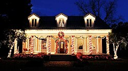
The Vickers House at Christmas, 2019
USA Louisiana location map.svg
Red pog.svg
Alto, Louisiana
Usa edcp location map.svg
Red pog.svg
Alto, Louisiana
Coordinates: 32°21′28″N91°51′35″W / 32.35778°N 91.85972°W / 32.35778; -91.85972
Country United States
State Louisiana
Parish Richland
Time zone UTC-6 (Central (CST))
  Summer (DST) UTC-5 (CDT)
ZIP code
71269
Area code 318
GNIS feature ID532147 [1]

Alto is an unincorporated community in Richland Parish, Louisiana, United States. The Vickers House, an 1870 Greek Revival building, is on the National Register of Historic Places. [2]

Etymology

Alto was likely named due to its lofty elevation. [3]

References

  1. U.S. Geological Survey Geographic Names Information System: Alto, Louisiana
  2. State of Louisiana Division of Historic Preservation's National Register staff (February 1986). "National Register of Historic Places Inventory/Nomination: Vickers House". National Park Service . Retrieved January 4, 2024. With accompanying 10 photos from 1986
  3. Leeper, Clare D'Artois (October 19, 2012). Louisiana Place Names: Popular, Unusual, and Forgotten Stories of Towns, Cities, Plantations, Bayous, and Even Some Cemeteries. LSU Press. p. 15. ISBN   978-0-8071-4740-5.