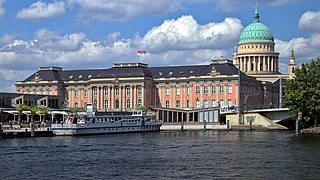
Potsdam is the capital and largest city of the German state of Brandenburg. It directly borders the German capital, Berlin, and is part of the Berlin/Brandenburg Metropolitan Region. It is situated on the River Havel some 25 kilometres southwest of Berlin's city centre.

Spandau is the westernmost of the 12 boroughs of Berlin, situated at the confluence of the Havel and Spree rivers and extending along the western bank of the Havel. It is the smallest borough by population, but the fourth largest by land area.

Köpenick is a historic town and locality (Ortsteil) in Berlin, situated at the confluence of the rivers Dahme and Spree in the south-east of the German capital. It was formerly known as Copanic and then Cöpenick, only officially adopting the current spelling in 1931. It is also known for the famous imposter Hauptmann von Köpenick.

The Spandau Citadel is a fortress in Berlin, Germany, one of the best-preserved Renaissance military structures of Europe. Built from 1559–94 atop a medieval fort on an island near the meeting of the Havel and the Spree, it was designed to protect the town of Spandau, which is now part of Berlin. In recent years it has been used as a museum and has become a popular tourist spot. Furthermore, the inner courtyard of the Citadel has served as an open air concert venue in the summertime since 2005.

Wannsee is a locality in the southwestern Berlin borough of Steglitz-Zehlendorf, Germany. It is the westernmost locality of Berlin. In the quarter there are two lakes, the larger Großer Wannsee and the Kleiner Wannsee, are located on the River Havel and are separated only by the Wannsee Bridge. The larger of the two lakes covers an area of 2.7 km2 (1.0 sq mi) and has a maximum depth of 9 m (30 ft).

Rathaus Spandau is one of the western termini of Berlin U-Bahn line U7. It was opened on 1 October 1984 with the line's extension from Rohrdamm to Rathaus Spandau. The station takes its name from the nearby Rathaus Spandau, the historic city hall of Spandau.

Altstadt Spandau is a station in the Spandau district of Berlin, on that city's U-Bahn line . It takes its name from the Altstadt Spandau, the historic central area of the former independent city of Spandau.

Zitadelle is a station on the Berlin U-Bahn line U7. It was opened on 1 October 1984 with the line's extension from Rohrdamm to Rathaus Spandau. Its name means "Citadel" in English and it was named for the historic Spandau Citadel. Unlike most U-Bahn stations, Zitadelle has side platforms. The station's interiors were also designed to resemble the citadel's style.
Cölln was the twin city of Old Berlin (Altberlin) from the 13th century to the 18th century. Cölln was located on the Fisher Island section of Spree Island, opposite Altberlin on the western bank of the River Spree, until the cities were merged by Frederick I of Prussia to form Berlin in 1710. Today, the former site of Cölln is the historic core of the modern Mitte locality of the Berlin-Mitte borough in central Berlin.
Grunewald is a locality (Ortsteil) within the Berlin borough (Bezirk) of Charlottenburg-Wilmersdorf. Famous for the homonymous forest, until 2001 administrative reform it was part of the former district of Wilmersdorf.

Landsberg is a town in the Saalekreis in the state of Saxony-Anhalt, Germany

Lehnin Abbey is a former Cistercian monastery in Lehnin in Brandenburg, Germany. Founded in 1180 and secularized during the Protestant Reformation in 1542, it has accommodated the Luise-Henrietten-Stift, a Protestant deaconesses' house since 1911. The foundation of the monastery in the newly established Margraviate of Brandenburg was an important step in the high medieval German Ostsiedlung; today the extended Romanesque and Gothic brickstone buildings, largely restored in the 1870s, are a significant part of Brandenburg's cultural heritage.
Golßen or Golssen is a town in the district of Dahme-Spreewald, in Brandenburg, Germany. It is the administrative seat of the Amt Unterspreewald.

The Margraviate of Brandenburg was a major principality of the Holy Roman Empire from 1157 to 1806 that played a pivotal role in the history of Germany and Central Europe.

Westend is a locality of the Berlin borough Charlottenburg-Wilmersdorf in Germany. It emerged in the course of Berlin's 2001 administrative reform on the grounds of the former Charlottenburg borough. Originally a mansion colony, it is today a quite densely settled, still affluent territory adjacent to Berlin's inner city in the east.

Pankow is a locality (Ortsteil) of Berlin in the district (Bezirk) of Pankow. Until 2001 it was an autonomous district with the localities of Karow, Niederschönhausen, Wilhelmsruh, Rosenthal, Blankenfelde, Buch and Französisch Buchholz.
Spandau is a locality (Ortsteil) of Berlin in the homonymous borough (Bezirk) of Spandau. The historic city is situated, for the most part, on the western banks of the Havel river. As of 2020 the estimated population of Spandau was 39,653.

Buch is a German locality (Ortsteil) within the Berlin borough (Bezirk) of Pankow. Situated on the Panke river, it is the city's northernmost quarter, chiefly known for its historic village centre and extended hospital premises.

John I, Margrave of Brandenburg was from 1220 until his death Margrave of Brandenburg, jointly with his brother Otto III "the Pious".
Otto III, nicknamed the pious was Margrave of Brandenburg jointly with his elder brother John I until John died in 1266. Otto III then ruled alone, until his death, the following year.

