Ben Nevis is the highest mountain in Scotland, the United Kingdom, and the British Isles. The summit is 1,345 metres (4,413 ft) above sea level and is the highest land in any direction for 739 kilometres. Ben Nevis stands at the western end of the Grampian Mountains in the Highland region of Lochaber, close to the town of Fort William.

Rockall is an uninhabitable granite islet in the North Atlantic Ocean. The United Kingdom claims that Rockall lies within its territorial sea and is part of its territory, but this claim is not recognised by Ireland. It and the nearby skerries of Hasselwood Rock and Helen's Reef are the only emergent parts of the Rockall Plateau. The rock was formed by magmatism as part of the North Atlantic Igneous Province during the Paleogene.
A Munro is defined as a mountain in Scotland with a height over 3,000 feet (914.4 m), and which is on the Scottish Mountaineering Club (SMC) official list of Munros; there is no explicit topographical prominence requirement. The best known Munro is Ben Nevis, the highest mountain in the British Isles at 4,411 ft.

Buachaille Etive Mòr, Scottish Gaelic: Buachaille Èite Mòr, 'great herdsman of Etive'), also known simply in English as 'The Buachaille', is a mountain at the head of Glen Etive in the Highlands of Scotland. Its pyramidal shape, as seen from the northeast, makes it one of the most recognisable mountains in Scotland, and one of the most depicted on postcards and calendars.
Handa Island or usually Handa, is an island in Eddrachillis Bay off the west coast of Sutherland, Scotland. It is 309 hectares and 123 metres (404 ft) at its highest point.
Thomas Walton Patey was a Scottish climber, mountaineer, doctor and writer. He was a leading Scottish climber of his day, particularly excelling on winter routes. He died in a climbing accident at the age of 38. He was probably best known for his humorous songs and prose about climbing, many of which were published posthumously in the collection One Man's Mountains.

Kinlochbervie is a scattered harbour village in the north west of Sutherland, in the Highland region of Scotland. It is the most northerly port on the west coast of Scotland.
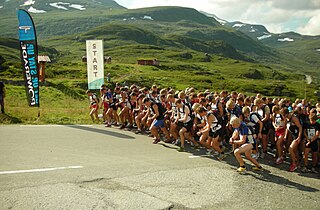
Fell running, also sometimes known as hill running, is the sport of running and racing, off-road, over upland country where the gradient climbed is a significant component of the difficulty. The name arises from the origins of the English sport on the fells of northern Britain, especially those in the Lake District. It has elements of trail running, cross country and mountain running, but is also distinct from those disciplines.
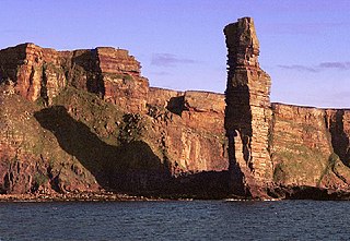
The Old Man of Hoy is a 449-foot (137-metre) sea stack on Hoy, part of the Orkney archipelago off the north coast of Scotland. Formed from Old Red Sandstone, it is one of the tallest stacks in the United Kingdom. The Old Man is popular with climbers, and was first climbed in 1966. Created by the erosion of a cliff through hydraulic action some time after 1750, the stack is not more than a few hundred years old, but may soon collapse into the sea.

Fair Head or Benmore is a 5-kilometre (3.1 mi) long, 200-metre (660 ft) high, mountain cliff, close to the sea, at the north-eastern corner of County Antrim, Northern Ireland. The cliff's sheer and vertical 100-metre (330 ft) high dolerite rock face is shaped into distinctive vertical columns like organ pipes, which formed 60 million years ago when a sill of igneous rock was injected between horizontal Carboniferous sediments.
Ian Clough (1937–1970) was a British mountaineer who was killed on the 1970 British Annapurna expedition led by Sir Chris Bonington to climb the south face of the Himalayan massif. He was later described by Bonington as "the most modest man I ever had the good luck to climb with" and "the kindest and most selfless partner I ever had."

Scotland is the mountainous country in the United Kingdom. Scotland's mountain ranges can be divided in a roughly north to south direction into: the Scottish Highlands, the Central Belt and the Southern Uplands, the latter two primarily belonging to the Scottish Lowlands. The highlands eponymously contains the country's main mountain ranges, but hills and mountains are to be found south of these as well. The below lists are not exhaustive; there are countless subranges throughout the country.

Sandwood Bay is a natural bay in Sutherland, on the far north-west coast of mainland Scotland. It is best known for its remote 1-mile-long (1.6 km) beach and Am Buachaille, a sea stack, and lies about 5 miles south of Cape Wrath. Behind the bay's large dunes, stretches the freshwater Sandwood Loch.

The Old Man of Stoer is a 60-metre-high (200 ft) sea stack of Torridonian sandstone in Sutherland, Scotland, close to the villages of Culkein and Stoer and the nearby Stoer Head Lighthouse. It is a popular climbing route.

Stac Lee is a sea stack in the St Kilda group off the west coast of Scotland. An island Marilyn, it is home to part of the world's largest colony of northern gannet.

Yell Sound is the Sound running between Yell and Mainland, Shetland, Scotland. It is the boundary between the Mainland and the North Isles and it contains many small islands. Sullom Voe, on the shores of which is a substantial oil terminal, is an arm of Yell Sound.

Stac Levenish or Stac Leibhinis is a sea stack in the St Kilda archipelago in Scotland. Lying 2.5 kilometres off Village Bay on Hirta, it is part of the rim of an extinct volcano that includes Dùn, Ruaival and Mullach Sgar.
The 2015 Tour de Yorkshire was a cycling stage race that took place in Yorkshire in May 2015. It was the first edition of the Tour de Yorkshire and was organised by Welcome to Yorkshire and the Amaury Sport Organisation, who also organised the Yorkshire stages of the 2014 Tour de France. The race started in Bridlington on 1 May and ended in Leeds on 3 May. It included three stages and was rated as a 2.1 event as part of the 2015 UCI Europe Tour.