
Ambanja is a city and commune in northern Madagascar. According to 2018 census the population of Ambanja was 60,321.

Diana is a region in Madagascar at the northern part of the island. It borders the regions of Sava to the southeast and Sofia to the southwest. It covers an area of 19,266 km2, and had a population of 889,736 in 2018. The regional capital is Antsiranana.

Ambanja is a district in northern Madagascar. It is a part of Diana Region and borders the districts of Ambilobe to the east, Bealanana to the south and Analalava to the south-west. The area is 5,999.72 km2 (2,317 sq mi) and the population was estimated at 190,435 in 2013.
Ambalahonko is a municipality in Madagascar. It belongs to the district of Ambanja, which is a part of Diana Region. According to 2001 census the population of Ambalahonko was 6,000.
Ankatafa is a municipality in Madagascar. It belongs to the district of Ambanja, which is a part of Diana Region. According to 2001 census the population of Ankatafa was 8,652.
Ankingameloko is a municipality in Madagascar. It belongs to the district of Ambanja, which is a part of Diana Region. According to 2001 census the population of Ankingameloko was 6,018.
Antranokarany is a municipality in Madagascar. It belongs to the district of Ambanja, which is a part of the Diana Region. According to a 2001 census, the population of Antranokarany was 7,221.
Antsakoamanondro is a municipality in Madagascar. It belongs to the district of Ambanja, which is a part of Diana Region. According to 2001 census the population of Antsakoamanondro was 5,622.
Antsatsaka is a municipality in Madagascar. It belongs to the district of Ambanja, which is a part of Diana Region. According to 2001 census the population of Antsatsaka was 10,214.
Antsirabe is a town and commune in Madagascar. It belongs to the district of Ambanja, which is a part of Diana Region. According to 2001 commune census the population of Antsirabe was 3,405.
Djangoa is a municipality in Madagascar. It belongs to the district of Ambanja, which is a part of Diana Region. According to 2001 census the population of Djangoa was 9,800.
Marotolana is a municipality in Madagascar. It belongs to the district of Ambanja, which is a part of Diana Region. According to 2001 census the population of Marotolana was 10,538.
Marovato is a municipality in Madagascar. It belongs to the district of Ambanja, which is a part of Diana Region. According to 2001 census the population of Marovato was 16,130.
Ambohimarina is a town and commune in northern Madagascar. It belongs to the district of Ambanja, which is a part of Diana Region. The population of the commune was estimated to be approximately 7,000 as of the 2001 census.
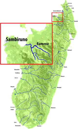
The Sambirano is a river of northwestern Madagascar in the region of Diana. It has its sources at the Maromokotra peak and flows through the Tsaratanana Reserve to the Indian Ocean. Its delta occupies 250 km2.
The Ramena River is a river of northwestern Madagascar in the region of Diana. It has its sources at the Maromokotra and is the main affluent of the Sambirano River. Its outlet is situated at Ambodimanga Ramena.
Bemaneviky Ouest is a municipality in Madagascar. It belongs to the district of Ambanja, which is a part of Diana Region. According to 2018 census the population was 5,841.
Bemaneviky Haut Sambirano is a municipality in Madagascar. It belongs to the district of Ambanja, which is a part of Diana Region. According to 2018 census the population was 11,355.
Benavony is a rural municipality in northern Madagascar. It belongs to the district of Ambanja, which is a part of Diana Region.
Maevatanana is a rural municipality in northern Madagascar, 24km from Ambanja. It lies in the valley of the Sambirano River that is the main cocoa producing area of Madagascar. 60% or 7,500 to 10,000 ton yearly is provided by this area. There is an unpaved road from Ambanja to Marovato, via Benavony, Ambodimanga Ramena, Bemaneviky Ouest, Maevatanana that is hardly navigable. Most of the exported cocoa is therefore transported with boats on the Sambirano River.

