Vidarbha is a geographical region in the west Indian state of Maharashtra. Forming the eastern part of the state, it comprises Amravati and Nagpur divisions. As per the 2011 Census, the region had a population of 23,003,179. The region occupies 31.6% of the total area and is home to 21.3% of the total population of Maharashtra. Situated in central India, it borders the state of Madhya Pradesh to the north, Chhattisgarh to the east, Telangana to the south and Marathwada and Uttar Maharashtra regions of Maharashtra to the west.

Buldhana district is located in the Amravati division of Maharashtra, India. It is situated at the western border of Vidarbha region and is 500 km away from the state capital, Mumbai. The district has towns and cities like deulghat, dhad, mehakar, Shegaon, Malkapur, Khamgaon, Lonar and Chikhli. It is surrounded by Madhya Pradesh in the north, Akola, Washim, and Amravati districts on the east, Jalna district on the south, and Jalgaon and Aurangabad districts on the west. Khamgaon is the largest city in the district.
Rajnandgaon is a city in Rajnandgaon District, in the state of Chhattisgarh, India. As of the 2011 census the population of the city was 163,122. Rajnandgaon district came into existence on 26 January 1973, as a result of the division of Durg district.

Bhandara District is an administrative district in the state of Maharashtra in India. The district headquarters are located at Bhandara. The district occupies an area of 3717 km2 and has a population of 1,200,334, of which 19.48% are urban as of 2011. The growth rate of Bhandara is 5.56% Bhandara has a mixed economy with agriculture, industries and forest resources. Bhandara is known for its large production of rice. Tumsar, a tahsil town, is a noted rice market. Bhandara town is also known as "Brass City" owing to the presence of a large brass products industry. Bhandara has several tourist destinations, like Ambagad Fort, Brahmi, Chinchgad, and Dighori.

Gondia district is an administrative district in the state of Maharashtra in India. The district headquarter is located at Gondia. The district occupies an area of 5,234 km2 (2,021 sq mi) and has a population of 1,322,507 of which 11.95% were urban. The district is part of Nagpur Division. There are 8 Talukas in Gondia District. Gondia Airport is second airport in Vidharbha region and serves city of Gondia.

Gondia is a city and municipal council in the Indian state of Maharashtra which serves the administrative headquarters of the eponymous administrative district. Gondia is also known as Rice City due to the abundance of rice mills in the area. Gondia Airport is the only airport in the district.

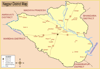
Nagpur district is a district in the Vidarbha region of Maharashtra state in central India. The city of Nagpur is the district administrative centre. The district is part of Nagpur Division.
Hingna is a town, tehsil and taluka in Nagpur district in Maharashtra state. Now Hingna is part of Nagpur Metropolitan Region and emerging as an industrial suburb of Nagpur city due to presence of various industrial developments. The Nagpur revenue division is part of Berar region in the state.
Nagpur West Assembly constituency is one of the seats in Maharashtra Legislative Assembly in India. It is one of the six Vidhan Sabha constituencies of Nagpur Lok Sabha constituency.
Armori Assembly constituency is one of the 288 Vidhan Sabha constituencies of Maharashtra state in central India.
Nagpur Chhattisgarh Railway was a 49 miles (79 km) 1,000 mmmetre gauge line owned by the provincial government and operated by the state railways. The line ran from Nagpur via Tumsar - Gondia and Dongargarh to Rajnandgaon. The initial section from Nagpur to Tumsar was opened on 6 July 1880, continuing to Tirora on 21 February 1881, Gondia on 18 May 1881, Amgaon on 25 November 1881 and completed to Rajnandgaon on 16 February 1882.
Amgaon Vidhan Sabha seat is one of the constituencies of Maharashtra Legislative Assembly, in India.
Gondia Junction serves Gondia in Gondia district in the Indian state of Maharashtra. It is one of the important railway stations in India of South East central railways zone railways. This station is India's third and first in Vidarbha to get mist cooling system.Its falls under nagpur division
Balharshah railway station is a railway station serving Ballarpur town, in Chandrapur district of Maharashtra state in India. Established by the Nizam's Guaranteed State Railway, it is now under the Nagpur CR railway division of Central Railway Zone of Indian Railways. It is an important junction on New Delhi–Chennai main line of Indian Railways. It is located at 185 m above sea level and has 5 platforms. The Ballarshah–Wardha–Nagpur section was electrified in 1989.

Tumsar Road Junction railway station serves Tumsar City and the surrounding area in Bhandara district in Maharashtra, India. The station consists of five platforms. The platforms are not well sheltered. It lacks many facilities including water and sanitation.
Chanda Fort Railway Station is one of the two main railway stations serving Chandrapur city in Chandrapur district in Maharashtra state in India. It is under Nagpur SEC railway division of South East Central Railway zone of Indian Railways. It is located on Gondia–Nagbhid–Balharshah line of Indian Railways.
Varangaon railway station is located near Varangaon town of Jalgaon district, Maharashtra. Its code is VNA. It has three platforms. Passenger, Express, and Superfast trains halt here.
Nagbhir Junction railway station is a junction railway station on Gondia–Nagbhir–Balharshah line and Nagpur–Nagbhir line in Nagpur SEC railway division of South East Central Railway Zone of Indian Railways. It serves Nagbhid town in Chandrapur district in Maharashtra state in India. It is located at 246 m above sea level and has two platforms. 12 trains stop at this station.
Manohar Gowardhan Chandrikapure is an Indian politician and a member of the 14th Maharashtra Legislative Assembly elected from the Arjuni-Morgaon constituency in the 2019 Maharashtra Legislative Assembly election. He is a member of Nationalist Congress Party.
Chichpalli railway station is a railway station serving Chichpalli village in Chandrapur district in Maharashtra state in India. It is under Nagpur SEC railway division of South East Central Railway Zone of Indian Railways. It is located on Gondia–Nagbhid–Balharshah line of Indian Railways.

