This article needs additional citations for verification .(July 2022) |
Gondia Gondiya, Gundiya | |
---|---|
City | |
Nickname: Rice city | |
Location in Maharashtra, India | |
Coordinates: 21°27′35″N80°11′42″E / 21.4598°N 80.195°E | |
Country | India |
State | Maharashtra |
Region | Vidarbha |
District | Gondia |
Government | |
• Type | Municipal Council |
• Body | Gondia Municipal Council |
• District collector [1] | Chinmay Gotmare, IAS |
• District Police Superintendent | Nikhil N. Pingale IPS [2] |
Area | |
• Total | 55 km2 (21 sq mi) |
• Rank | 1st in Gondia District Vidarbha: 5th |
Elevation | 300 m (1,000 ft) |
Population (2011) | |
• Total | 132,821 |
• Rank | 1st in Gondia District Vidharbha: 5th |
• Density | 2,400/km2 (6,300/sq mi) |
Demonym | Gondiakar |
Language | |
• Official | Marathi [3] |
Time zone | UTC+5:30 (IST) |
PIN | 441601,441614 |
Telephone code | +91-07182 |
Vehicle registration | MH-35 |
Literacy Rate | 93.70% |
Sex ratio | 991 per 1000 male. ♂/♀ |
HDI | 0.701 (Medium) |
Nearest city | Tirora (33km) |
Website | gondia |
Gondia (also spelled Gondiya) is a city and municipal council in the Indian state of Maharashtra which serves the administrative headquarters of the eponymous administrative district. [4] Gondia is also known as Rice City due to the abundance of rice mills in the area. [5] [ failed verification ] Gondia Airport (also known as Birsi airport) is the only airport in the district.
The region is named after the Gondi people, an Adivasi group in central India. During British Rule , Proprietor of Gondia was Ponwar Rajpoot. [6]
During British rule in India, the Great Famine of 1876–78 provided an opportunity for the construction of a 150-kilometre-long (93 mi) metre-gauge rail link called the Nagpur Chhattisgarh Railway, connecting Nagpur with Rajnandgaon. Gondia railway station was created when this line began operation in December 1888. Bengal Nagpur Railway (BNR) was formed in 1887 to upgrade and extend this line, and in 1902 BNR was contracted to provide a railway line from Gondia to Jabalpur with branches from Nainpur to Mandla as well as Nainpur to Seoni and Chhindwara. With these links and the commerce they brought, Gondia grew and prospered. [7] [ pages needed ] In the year 1877 Near Darekasa cave Swami Vivekananda occurred his "First Trance" reference book "Journey of Swami Vivekananda to Raipur and His First Trance"(23)
Climate data for Gondia (1981–2010, extremes 1946–2012) | |||||||||||||
---|---|---|---|---|---|---|---|---|---|---|---|---|---|
Month | Jan | Feb | Mar | Apr | May | Jun | Jul | Aug | Sep | Oct | Nov | Dec | Year |
Record high °C (°F) | 34.5 (94.1) | 38.5 (101.3) | 42.5 (108.5) | 46.1 (115.0) | 47.5 (117.5) | 47.5 (117.5) | 44.2 (111.6) | 38.4 (101.1) | 39.4 (102.9) | 38.0 (100.4) | 35.7 (96.3) | 35.1 (95.2) | 47.5 (117.5) |
Mean daily maximum °C (°F) | 28.5 (83.3) | 31.2 (88.2) | 35.9 (96.6) | 40.3 (104.5) | 42.3 (108.1) | 37.9 (100.2) | 31.5 (88.7) | 30.6 (87.1) | 32.1 (89.8) | 32.6 (90.7) | 30.9 (87.6) | 28.9 (84.0) | 33.6 (92.5) |
Mean daily minimum °C (°F) | 13.2 (55.8) | 15.6 (60.1) | 19.9 (67.8) | 24.2 (75.6) | 27.7 (81.9) | 26.8 (80.2) | 24.1 (75.4) | 24.0 (75.2) | 23.6 (74.5) | 21.4 (70.5) | 16.6 (61.9) | 12.6 (54.7) | 20.8 (69.4) |
Record low °C (°F) | 6.6 (43.9) | 6.7 (44.1) | 11.4 (52.5) | 11.6 (52.9) | 13.8 (56.8) | 20.4 (68.7) | 19.8 (67.6) | 18.3 (64.9) | 19.2 (66.6) | 13.3 (55.9) | 8.5 (47.3) | 5.0 (41.0) | 5.0 (41.0) |
Average rainfall mm (inches) | 24.3 (0.96) | 22.9 (0.90) | 13.9 (0.55) | 8.8 (0.35) | 10.6 (0.42) | 180.5 (7.11) | 386.1 (15.20) | 374.5 (14.74) | 177.6 (6.99) | 46.5 (1.83) | 13.6 (0.54) | 11.4 (0.45) | 1,270.7 (50.03) |
Average rainy days | 1.4 | 1.7 | 1.4 | 0.9 | 1.0 | 8.6 | 16.2 | 16.8 | 8.9 | 3.2 | 0.6 | 0.6 | 61.4 |
Average relative humidity (%) (at 17:30 IST) | 48 | 37 | 30 | 25 | 25 | 50 | 73 | 78 | 71 | 57 | 51 | 47 | 50 |
Source 1: India Meteorological Department [8] [9] | |||||||||||||
Source 2: Government of Maharashtra [10] |
Gondia is very close to the state of Madhya Pradesh, Chhattisgarh and is considered the gateway to Maharashtra from central and eastern India. Tirora is only nearby city. Gondia municipal council was established in 1920. At that time Gondia had only 10 wards population up to 20,000 and an area of 7.5 km2. Gondia has 42 wards, as well as population nearing up to 2 lakhs. The urbanisation has crossed municipal limits merging into nearby villages like Kudwa, Katangi, Fulchur, Nagra, Karanja, Murri, Pindkepar, and Khamari. The Ministry of Urban Development has recently[ when? ] announced to merge 20 nearby villages into Gondia to give the city status of Municipal Corporation. It is connected with National Highway 543 and 753.
As per 2011 Indian Census, Gondia municipal corporation had a total population of 132,889, of which 66,756 were males and 66,133 females. Children in the age range of 0 to 6 were 12,835. The effective literacy (of population 7 years and above) of the city was 93.70%. [11]
Year | Male | Female | Total Population | Change | Religion (%) | |||||||
---|---|---|---|---|---|---|---|---|---|---|---|---|
Hindu | Muslim | Christian | Sikhs | Buddhist | Jain | Other religions and persuasions | Religion not stated | |||||
2001 [12] | 61418 | 59484 | 120902 | - | 77.072 | 7.147 | 0.524 | 0.779 | 13.508 | 0.817 | 0.137 | 0.015 |
2011 [13] | 66500 | 66313 | 132813 | 9.90 | 76.228 | 7.483 | 0.472 | 0.760 | 13.804 | 0.692 | 0.088 | 0.473 |
Graphs are unavailable due to technical issues. There is more info on Phabricator and on MediaWiki.org. |
The city has a large number of rice mills. [14] [15] [ failed verification ] Agriculture is the main economic activity in Gondia. The main agricultural crops are paddy and sugarcane. [16] [ failed verification ]
Adani Power Maharashtra Limited (APML), is 3 km away from Tirora on Tirora-Gondia state road. Coal is transported to Adani power, Ltd through a railway which is connected to Kachewani Railway Station. Water is being used from nearby weir constructed on Wainganga River. An 85.89% subsidiary of Adani Power Limited is implementing 3300 MW Thermal Power Station in Tirora.
The Mumbai–Nagpur–Kolkata Road is the only national highway passing through the district, covering a total distance of 99.37 km (62 mi). Gondia is situated about 170 km by road from Nagpur of Vidarbha region. The district has road links to adjoining districts Chandrapur, Bhandara, Nagpur. The city is well connected by roads. It takes around 4 hours journey from Nagpur by State Transport Bus to reach Gondia. Gondia has bus connectivity to Jabalpur, Nagpur, Raipur and Hyderabad.
Gondia Junction railway station is a junction in Maharashtra, with heavy passenger and goods traffic. It is an A-Grade station.
It lies on the Howrah–Mumbai route. The station has seven platforms, each with potable water, tea stalls, benches and waiting sheds. There is also a fruit stall and a bookstall. The station is equipped with air-conditioned waiting rooms for passengers travelling by upper accommodation classes and a waiting hall for passengers travelling by lower accommodation classes.
The Gondia–Jabalpur Junction (Madhya Pradesh) section of South East Central Railway runs north–south, along the valley of the Wainganga River. The line was formerly narrow gauge (762 mm [2 ft 6 in]) along its entire length, but the section between Gondia and Balaghat was converted to broad gauge in 2005–2006, [17] connecting Balaghat to India's national broad-gauge network. Work is completed to convert the Balaghat–Jabalpur section to broad gauge as well.
Railway milestones for Gondia include:
Gondia Airport is situated near Kamtha village, 12 km (7.5 mi) from Gondia. This airstrip was built by the British in 1940, during World War II. [20] Initially run by the Public Works Department, it was taken over by the state-owned Maharashtra Industrial Development Corporation (MIDC) from August 1998 [21] to December 2005, after which it has been operated by the Airports Authority of India (AAI). The airport's runway has been extended to 2,300 metres (7,500 ft) to accommodate Airbus A-320, Boeing 737 and similar aircraft. [22]
Other nearby airports to Gondia Airport (GDB) include Nagpur (NAG) (124.8 km), Raipur (RPR) (163.2 km) and Jabalpur (JLR) (192.2 km).
Bhandara District is an administrative district in the state of Maharashtra in India. The district headquarters are located at Bhandara. The district occupies an area of 3717 km2 and has a population of 1,200,334, of which 19.48% are urban as of 2011. The growth rate of Bhandara is 5.56% Bhandara has a mixed economy with agriculture, industries and forest resources. Bhandara is known for its large production of rice. Tumsar, a tahsil town, is a noted rice market. Bhandara town is also known as "Brass City" owing to the presence of a large brass products industry. Bhandara has several tourist destinations, like Ambagad Fort, Brahmi, Chinchgad, and Dighori.
The Wainganga is a river in India originating in the Mahadeo Hills in Mundara in Gondwana region near the village Gopalganj in Seoni, Madhya Pradesh. It is a key tributary of the Godavari. The river flows south in a winding course through the states of Madhya Pradesh and Maharashtra, roughly 580 km (360 mi). After joining the Wardha River, the united stream, which is known as the Pranahita River, empties into the Godavari River at Kaleshwaram, Telangana.
Balaghat district is a district of Madhya Pradesh state in Central India. Its belongs to Jabalpur Division. Balaghat city is Administrative Headquarter of Balaghat District.
Seoni is a city and a municipality in Seoni district in the Indian state of Madhya Pradesh. This tribal household dominated district was formed in the year 1956.
Bhandara is a city located in the Bhandara district of Maharashtra State of India, near the bank of confluence of river Wainganga and its tributary Sur. It serves the administrative headquarters of eponymous Bhandara Taluka and Bhandara district. It is connected with NH-53 and NH-247.
Chhuikhadan is a city municipality and district in Khairagarh-Chhuikhadan-Gandai district in the Indian state of Chhattisgarh, India. Chhuikhadan is also known as "City of Martyrs".
Nainpur is a town and Municipal City in the Mandla district, of the Indian state of Madhya Pradesh.
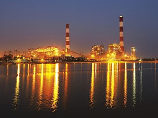
Tirora is a city and a municipal council in Gondia district of Maharashtra, India. Adani Power Maharashtra Limited, Tirora is the largest coal based Thermal Power Plant in the state of Maharashtra, India. The plant has a capacity to generate 3300 MW power through its 5 units of 660 MW capacity.
Waraseoni is a tehsil and Nagar Palika Parishad (municipality) in Balaghat district in the Indian state of Madhya Pradesh. It is situated 16 km (10 mi) from the district headquarters. Waraseoni is second most populous town in Balaghat District after Balaghat.
Mohadi is a Town and eponymous headquarters of Mohadi taluka in Bhandara district in the state of Maharashtra, India. It is located on newly declared National Highway NH 543K which connects cities of Bhandara and Balaghat in Maharashtra and Madhya Pradesh respectively.
Keolari is a town and a tehsil in Seoni district in the state of Madhya Pradesh, India. The confluence of the Wainganga and Sagar rivers is located at Keolari. The town has a District Institute of Education Training. (D.I.E.T.).
Balaghat Junction is situated on the Jabalpur–Nainpur–Gondia section of South East Central Railway, in the Indian state of Madhya Pradesh. Rail routes through the junction include routes towards Jabalpur, Gondia, Katangi on the Satpura Railway. The "10001 Satpura Express", a narrow-gauge train, was started in 1901 by the British Government and completed 100 years of service in 2001. This train used to hold the unique distinction of operating first-class service on narrow-gauge track; it was the world's fastest narrow-gauge train.
Netaji Subhash Chandra Bose Itwari is a Railway Junction Station and Terminus about 5 km from Nagpur railway station in Maharashtra state of India.
The Satpura Railway was a 2 ft 6 in narrow-gauge railway in the states of Madhya Pradesh and Maharashtra in central India.
The Bilaspur–Nagpur section is part of the Howrah–Nagpur–Mumbai line and connects Bilaspur in the Indian state of Chhattisgarh and Nagpur in Maharashtra. Part of one of the major trunk lines in the country, it passes through a forested plateau region interspersed with fertile valleys.
Gondia Junction serves Gondia in Gondia district in the Indian state of Maharashtra. It is one of the important railway stations in India of South East central railways zone railways. This station is India's third and first in Vidarbha to get mist cooling system.Its falls under nagpur division
Maharashtra State Highway 249 Also SH 249 is a state highway in Nagpur, Bhandara, and Gondia Districts in the state of Maharashtra. This state highway touches Katol, Savner, Parseoni, Ramtek, Tumsar,Tirora and Gondia.
Nainpur Junction railway station is a railway station in Mandla District, Madhya Pradesh. Its code is NIR. It serves the town of Nainpur.
Samnapur railway station is a small railway station in Balaghat district, Madhya Pradesh. Its code is SMC. It serves Samnapur village.
Lamta railway station is a small railway station in Balaghat district, Madhya Pradesh. Its code is LTA. It serves Lamta village.