Wilbarger County is a county located in the U.S. state of Texas. As of the 2010 census, the population was 13,535. The county seat is Vernon. The county was created in 1858 and later organized in 1881. Wilbarger is named for Josiah Pugh Wilbarger and Mathias Wilbarger, two early settlers.
Stephens County is a county located in the U.S. state of Texas. As of the 2010 census, its population was 9,630. Its county seat is Breckenridge. The county was created in 1858 and organized in 1876. It was originally named Buchanan County, after U.S. President James Buchanan, but was renamed in 1861 for Alexander H. Stephens, the vice president of the Confederate States of America.

Reynolds is a village in Mercer and Rock Island Counties in the U.S. state of Illinois. The population was 508 at the 2000 census. Only a small portion on the south side is in Mercer County. The village was founded in 1876.

Zuehl is an unincorporated area and census-designated place in western Guadalupe County, Texas, United States. It is part of the San Antonio Metropolitan Statistical Area. Located on Cibolo Creek, it lies 13 miles (21 km) southwest of Seguin. The population was 362 at the 2010 census.

Mertens is a town in Hill County, Texas, United States. It is located along State Highway 22. The population was 125 at the 2010 census.
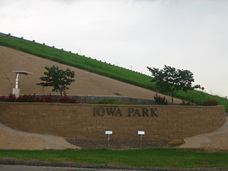
Iowa Park is a city in Wichita County, Texas, United States. It is part of the Wichita Falls, Texas Metropolitan Statistical Area. The population was 6,355 at the 2010 census.
Steinhatchee is a Gulf coastal community in the southern part of Taylor County, Florida, United States. Steinhatchee is located at 29°40′16″N83°23′15″W, 33 miles (53 km). Steinhatchee is 38.09 miles south of the county seat of Perry. Just across the Steinhatchee River is Jena, which is in Dixie County. Steinhatchee is 19.27 miles north of the town of Cross City. The Stein in Steinhatchee is pronounced as if it were spelled Steen, rather than Stine. The name Steinhatchee was derived from the Native American "esteen hatchee" meaning river (hatchee) of man (esteen). Since the early 19th century, the village of Steinhatchee played an integral part in the foresting industry, particularly cedar used for making pencils, as well as fishing, crabbing and scalloping. The Steinhatchee River also flows by the community and into the Gulf of Mexico.
Stoneburg is an unincorporated community in Montague County, Texas, United States. It had a population of approximately 51 in 1990.
Pipe Creek is an unincorporated community in Bandera County, Texas, United States. It had a population of approximately 66 in 1990. It is part of the San Antonio Metropolitan Statistical Area.

Vincent is a census-designated place in southern Barlow Township, Washington County, Ohio, United States. Although it is unincorporated, it has a post office, with the ZIP code of 45784. It lies along State Route 339 near Tupper Creek, a subsidiary of the Little Hocking River, which in turn meets the Ohio River at Little Hocking to the south.

Westchester is an unincorporated community in Bearcreek Township, Jay County, Indiana.
Shad Landing is an unincorporated community in Accomack County, Virginia.
Leming is an unincorporated community and census-designated place in Atascosa County, Texas, United States. As of the 2010 census it had a population of 946. This was a new CDP for the 2010 census. The community is part of the San Antonio Metropolitan Statistical Area. Although it is unincorporated, Leming has a post office, with the ZIP code of 78050.
Leipsic is an unincorporated community in Northeast Township, Orange County, in the U.S. state of Indiana.
Golden is a ghost town in Okanogan County, Washington, United States. Golden was a mining town which was founded around 1887. The discovery of gold in the area led to the creation of Golden. By 1892 more than thirty buildings were located between the mines and Wannacut Lake. The town was called Golden due to the promise continued gold in the area. Golden had a population of 300 in its heyday. The town had a general store, restaurant, saloon and post office along with other false fronted businesses. As the gold became depleted the town became more deserted. By 1910 under 100 people remained in Golden. The town eventually became a ghost town. The depression of the thirties brought some new inhabitants to Golden, but eventually it was deserted. Today little remains of the town.

Laurents Point is an unincorporated community in Vermilion Parish, Louisiana, United States.
West Franklin is an unincorporated community in Marrs Township, Posey County, in the U.S. state of Indiana.
Fincastle is an unincorporated community in Franklin Township, Putnam County, in the U.S. state of Indiana.
Murray is a populated place in Young County, Texas. It lies at an elevation of 1214 feet / 370 meters at the intersection of Farm roads 209 and 578, fourteen miles southwest of Graham, Texas.
Highbanks is an unincorporated community in Tippecanoe Township, Kosciusko County, in the U.S. state of Indiana.