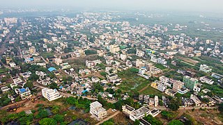
Chintalapudi is a town municipality and mandal headquarters in West Godavari district of the Indian state of Andhra Pradesh.
Kommugudem is a village in West Godavari district of the Indian state of Andhra Pradesh. It is located in Tadepalligudem mandal of Eluru revenue division. The nearest train station is Kaikaram (KKRM) located at a distance of 40.26 Km.

Jagannadhapuram is a village in West Godavari district of the Indian state of Andhra Pradesh. It is located in Tadepalligudem mandal of Eluru revenue division.
Bhogolu is a village in West Godavari district of the Indian state of Andhra Pradesh. It is located in Lingapalem mandal of Eluru revenue division. Eluru is the nearest railway station which is located more than 10Kms.

Tangellamudi is a census town in West Godavari district of the Indian state of Andhra Pradesh. It is in Eluru mandal of Eluru revenue division. The town is a constituent of Eluru urban agglomeration. The nearest railway station is in Powerpet and is 1.5 km.

Denduluru is a village in the West Godavari district of the Indian state of Andhra Pradesh. It is located on the north-east side of district headquarters Eluru at a distance of 11 km. It is a member of the Eluru revenue division. The Bhimalingadibba or the mounds are one of the centrally protected monuments of national importance.

Komadavole is an out growth of Eluru city in West Godavari district of the Indian state of Andhra Pradesh. It is located in Eluru mandal of Eluru revenue division. It is also a constituent of Eluru Urban Agglomeration.

Pinakadimi is a village in West Godavari district of the Indian state of Andhra Pradesh. It is located in Pedavegi mandal of Eluru revenue division. It is located at a distance of 7 km from district headquarters Eluru city.

Dondapadu is a village in West Godavari district of the Indian state of Andhra Pradesh. It is located in Pedavegi mandal of Eluru revenue division. It is located at a distance of 5 km from district headquarters Eluru city.

Chodimella is a village in West Godavari district of the Indian state of Andhra Pradesh. It is located in Eluru mandal of Eluru revenue division. The town is a constituent of Eluru urban agglomeration.

Jalipudi is a village in West Godavari district of the Indian state of Andhra Pradesh. It is located in Eluru mandal of Eluru revenue division. The town is a constituent of Eluru urban agglomeration.

Madepalle is a village in West Godavari district of the Indian state of Andhra Pradesh. It is located in Eluru mandal of Eluru revenue division. The town is a constituent of Eluru urban agglomeration.

Malkapuram is a village in West Godavari district of the Indian state of Andhra Pradesh. It is located in Eluru mandal of Eluru revenue division. The town is a constituent of Eluru urban agglomeration.

Ponangi is a village in West Godavari district of the Indian state of Andhra Pradesh. It is located in Eluru mandal of Eluru revenue division. The nearest railway station is located at Eluru.

Edulakunta is a village in West Godavari district of the Indian state of Andhra Pradesh. It is located in Pedapadu mandal of Eluru revenue division. Kamareddi railway Station is the nearest train station located at a distance of more than 10Km.

Koniki is a village in West Godavari district of the Indian state of Andhra Pradesh. It is located in Pedapadu mandal of Eluru revenue division. The nearest railway station is located at Chirala which is more than 10 Km from Koniki.

Kothuru is a village in West Godavari district of the Indian state of Andhra Pradesh. It is located in Pedapadu mandal of Eluru revenue division.

Rajupeta is a village in West Godavari district of the Indian state of Andhra Pradesh. It is located in Pedapadu mandal of Eluru revenue division. The nearest train station is Vinnamangalam (VGM) located at a distance of 20.21 Km.

Allipalle is a village in West Godavari district of the Indian state of Andhra Pradesh. The nearest railway station is Sitampet(STPT) located at a distance of 47.79 Km.

Chintampalle is a village in West Godavari district of the Indian state of Andhra Pradesh. It is administered under Eluru revenue division.


