An-Naqura

Last updated

Contents

An Naqura
Arabic transcription(s)
   Arabic الناقورة
   Latin an-Naqoura (official)
al-Nakura (unofficial)
SouthNekuraIbrahimAlAdham8369.JPG
Houses in south An-Naqura. Up on the hill on the right is Ibrahim al-Adham Sheikh tomb.
Palestine location map wide.png
Red pog.svg
An Naqura
Location of An Naqura within Palestine
Coordinates: 32°15′56″N35°12′05″E / 32.26556°N 35.20139°E / 32.26556; 35.20139
Palestine grid 169/185
State State of Palestine
Governorate Nablus
Government
  Type Village council
  Head of MunicipalityMuhammad Hashish
Population
 (2017) [1]
  Total
1,786
Name meaningEn Nakurah: the horn or trumpet [2]

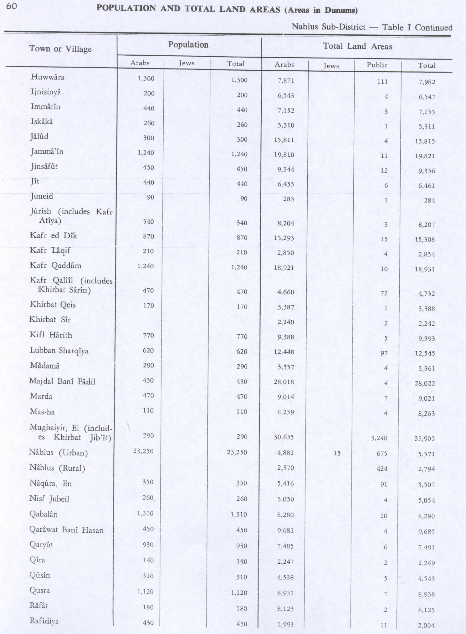
An-Naqura (Arabic : الناقورة, also spelled al-Nakura) is a Palestinian village in the Nablus Governorate in northern West Bank, located 10 kilometers northwest of Nablus and adjacent to the Israeli settlement of Shavei Shomron. According to the Palestinian Central Bureau of Statistics (PCBS) census, the village had a population of 1,545 in 2007 and 1,786 in 2017. [1] [3] An-Naqura is administered by a ten-member village council headed by Muhammad Hashish. [4]

Location

An Naqura is located 7.57 km northwest of Nablus. It is bordered by Zawata to the east, Ijnisinya to the east and north, Sabastiya to the north, Deir Sharaf to the west and south, and Beit Iba to the south. [5]

History

Pottery sherds from the Early Bronze I, Iron Age II, late Roman, Byzantine, early Muslim and Medieval eras have been found here. [6]

Ottoman era

It has been suggested that An-Naqura was the village named Aqbara or Aquira, in the 1596 Ottoman tax records. It had 23 households and 5 bachelors, all Muslim. [7]

In 1667, Anthimus mentions a Christian population in this village, though it had no church. [8]

In 1838 Robinson noted the village as en-Nakurah in the Wady esh-Sha'ir district, west of Nablus. [9] [10]

In 1870, Victor Guérin noted it as a village on a hill, with 300 inhabitants, where ancient stones were used in the house-walls. [11]

In 1870/1871 (1288 AH), an Ottoman census listed the village in the nahiya (sub-district) of Wadi al-Sha'ir. [12]

In 1882, the PEF's Survey of Western Palestine (SWP) described En Nakurah: "A small stone village on the slope of the hill. It has olives, which appear to grow half wild, and a spring of good water, apparently perennial, in the valley to the north, near which are vegetable gardens. A small Mukam stands above the village, on the south." [13]

British Mandate era

In the 1922 census of Palestine conducted by the British Mandate authorities, Nakura had a population of 233 Muslims, [14] increasing in the 1931 census to 247, still all Muslims, in a total of 69 houses. [15]

In the 1945 statistics En Naqura had a population of 350 Muslims [16] and a total of 5,507 dunams of land, according to an official land and population survey. [17] Of this, 591 dunams were plantations and irrigable land, 3,444 were used for cereals, [18] while 27 dunams were built-up land. [19]

Jordanian era

In the wake of the 1948 Arab–Israeli War, and after the 1949 Armistice Agreements, An-Naqura came under Jordanian rule.

The Jordanian census of 1961 found 487 inhabitants. [20]

Post-1967

Since the Six-Day War in 1967, An-Naqura has been held under Israeli occupation. A census recorded by the Israeli Civil Administration that same year recorded 610 persons, of whom 37 were refugees from Israel. [21]

After the 1995 accords, 14% of village land was classified as Area A, 51% was classified as Area B, while the remaining 35% was classified as Area C. Israel has “confiscated” 680 dunums of village land for the Israeli settlement of Shavei Shomron. [22]

Demography

Local origins

Some of an-Naqura's inhabitants have origins in Burqa and a few nearby khirbets. [23]

Related Research Articles

<span class="mw-page-title-main">Tayasir</span> Municipality type D in Tubas, State of Palestine

Tayasir is a Palestinian village in the Tubas Governorate of the State of Palestine, in the northern West Bank. It is located 3 kilometers northeast of Tubas and 22 kilometers northeast of Nablus. Nearby localities include al-Aqabah to the east, al-Bikai'a to the northeast, Salhab to the north, 'Aqqaba to the west and ath-Thaghra to the southwest. According to the Palestinian Central Bureau of Statistics (PCBS), Tayasir had a population of 2,489 in 2007 and a population of 2,878 by 2017.

<span class="mw-page-title-main">Bal'a</span> Municipality type C in Tulkarm, State of Palestine

Bal'a is a Palestinian town in the Tulkarm Governorate, located approximately nine kilometers northeast of Tulkarm in the northern West Bank and three kilometers away from the highway connecting Tulkarm with Nablus.

<span class="mw-page-title-main">Bizzariya</span> Municipality type D in Nablus, State of Palestine

Bizzariya is a Palestinian village in the northern West Bank, located 13.3 kilometers northwest of Nablus at the northernmost point of the Nablus Governorate. It is situated in a valley, having an altitude of 460 meters above sea level. According to the Palestinian Central Bureau of Statistics, Bizzariya had a population of over 2,252 inhabitants in 2007 and 2,794 by 2017.

<span class="mw-page-title-main">Qabalan</span> Municipality type C in Nablus, State of Palestine

Qabalan is a Palestinian town in the Nablus Governorate in the eastern West Bank, located 19 kilometers (12 mi) southeast of Nablus. According to the Palestinian Central Bureau of Statistics (PCBS), the town had a population of 8,195 inhabitants in 2017.

<span class="mw-page-title-main">Beit Iba</span> Municipality type C in Nablus, State of Palestine

Beit Iba is a Palestinian village in the Nablus Governorate in the North central West Bank, located 7 kilometers northwest of Nablus. According to the Palestinian Central Bureau of Statistics (PCBS), the village had a population of 4,079 inhabitants in 2017.

Baqa al-Hatab is a Palestinian village in the Qalqilya Governorate in the western area of the West Bank, located 20 kilometers southwest of Nablus. According to the Palestinian Central Bureau of Statistics, the village had a population of 1,943 inhabitants in 2017.

<span class="mw-page-title-main">Beit Imrin</span> Municipality type D in Nablus, State of Palestine

Beit Imrin is a Palestinian village in the Nablus Governorate in northern West Bank, located 18 kilometers northwest of Nablus. According to the Palestinian Central Bureau of Statistics (PCBS), the village had a population of 2,821 inhabitants in 2007 and 3,323 by 2017.

<span class="mw-page-title-main">Deir Sharaf</span> Municipality type D in Nablus, State of Palestine

Deir Sharaf is a Palestinian town in the Nablus Governorate of the State of Palestine, in the northern West Bank, located northwest of Nablus. According to the Palestinian Central Bureau of Statistics (PCBS), the town had a population of 2,949 inhabitants in 2017.

<span class="mw-page-title-main">Majdal Bani Fadil</span> Municipality type D in Nablus, State of Palestine

Majdal Bani Fadil is a Palestinian village in the Nablus Governorate of the northern West Bank, located 23 kilometers (14 mi) southeast of Nablus. According to the Palestinian Central Bureau of Statistics (PCBS), the town had a population of 2,907 in 2017. Majdal Bani Fadil is under the administration of a nine-member village council headed by Walid Othman. The main economic activities are herding and agriculture, specifically olives, grapes, prunes and figs. The main road connecting Majdal Bani Fadil to Ramallah and Nablus and Jericho has been closed off to the village since 2000 during the Second Intifada.

<span class="mw-page-title-main">Qusin</span> Municipality type D in Nablus, State of Palestine

Qusin is a Palestinian town in the Nablus Governorate in northern West Bank, located 8 kilometers West of Nablus. According to the Palestinian Central Bureau of Statistics (PCBS), the town had a population of 2,251 inhabitants in 2017.

<span class="mw-page-title-main">Yasid</span> Municipality type D in Nablus, State of Palestine

Yasid is a Palestinian town in the Nablus Governorate in northern West Bank, located 15 kilometers northeast of Nablus. According to the Palestinian Central Bureau of Statistics (PCBS), the town had a population of 2,291 inhabitants in mid-year 2006 and 2,505 by 2017.

<span class="mw-page-title-main">Zawata</span> Municipality type D in Nablus, State of Palestine

Zawata is a town in the Nablus Governorate in the northern West Bank, Palestine, located 6 kilometers northwest of Nablus. According to the Palestinian Central Bureau of Statistics (PCBS), the town had a population of 2,537 inhabitants in 2017.

<span class="mw-page-title-main">Rujeib</span> Municipality type D in Nablus, State of Palestine

Rujeib is a Palestinian town in the Nablus Governorate of the State of Palestine, in the northern West Bank, located 3 kilometers southeast of Nablus. According to the Palestinian Central Bureau of Statistics (PCBS), the town had a population of 5,964 inhabitants in 2017.

Talfit is a Palestinian village in the Nablus Governorate in the northern West Bank, located southeast of Nablus. According to the Palestinian Central Bureau of Statistics (PCBS) census, it had a population of 3,591 in 2017.

Mirka is a Palestinian village in the West Bank, located 12 km (7.5 mi) Southwest of the city of Jenin in the northern West Bank. According to the Palestinian Central Bureau of Statistics, the town had a population of 1,555 inhabitants in mid-year 2006 and 2,203 by 2017.

<span class="mw-page-title-main">Misilyah</span> Municipality type D in Jenin, State of Palestine

Misilyah, sometimes spelled Mithiliyeh and Misiliyeh, is a Palestinian village in the northern West Bank of the State of Palestine, located 14 kilometers south of the city of Jenin. According to the Palestinian Central Bureau of Statistics, the village had a population of 2,252 inhabitants in mid-year 2006 and 2,884 by 2017. The main agricultural crops cultivated in Misilya are olives, grapes, figs, and vegetables. Roman and Islamic ruins have been found in the village.

<span class="mw-page-title-main">Ijnisinya</span> Municipality type D in Nablus, State of Palestine

Ijnisinya is a Palestinian village located six kilometres northwest of Nablus in the Nablus Governorate. Most of the working-age inhabitants live as farmers or governmental workers. It had a population of about 585 in 2017. Ijnisinya is governed by a village council.

<span class="mw-page-title-main">Azzun</span> Palestinian town in Qalqilya, State of Palestine

Azzun is a Palestinian town in Qalqilya Governorate in the northern West Bank, located 9 kilometers east of Qalqilya and 24 kilometers south of Tulkarm.

<span class="mw-page-title-main">Nisf Jubeil</span> Local Development Committee in Nablus, State of Palestine

Nisf Jubeil is a Palestinian village in the Nablus Governorate in the northern West Bank, located northwest of Nablus. According to the Palestinian Central Bureau of Statistics (PCBS) census, it had a population of 394 in 2007. There were a total of 83 households and 17 business establishments. By 2017, the population was 471.

Telfit is a Palestinian village in the Jenin Governorate of Palestine, in the northern West Bank, located southeast of Jenin. According to the Palestinian Central Bureau of Statistics (PCBS) census, the village had a population of 238 in 2007 and 439 by 2017.

References

  1. 1 2 Preliminary Results of the Population, Housing and Establishments Census, 2017 (PDF). Palestinian Central Bureau of Statistics (PCBS) (Report). State of Palestine. February 2018. pp. 64–82. Retrieved 2023-10-24.
  2. Palmer, 1881, p. 188
  3. 2007 PCBS Census. Palestinian Central Bureau of Statistics. p. 108.
  4. Naqura Profile. Jerusalem Media and Communications Center (JMCC).
  5. An Naqura Village profile, ARIJ, p. 4
  6. Zertal, 2004, p. 478
  7. Hütteroth and Abdulfattah, 1977, p. 127; cited in Zertal, 2004, p. 478
  8. Ellenblum, 2003, p. 248
  9. Robinson and Smith, 1841, vol 3, Appendix 2, p. 129
  10. Robinson and Smith, 1841, vol 3, p.138
  11. Guérin, 1875, p. 186
  12. Grossman, David (2004). Arab Demography and Early Jewish Settlement in Palestine. Jerusalem: Magnes Press. p. 253.
  13. Conder and Kitchener, 1882, SWP II, p. 160
  14. Barron, 1923, Table IX, Sub-district of Nablus, p. 24
  15. Mills, 1932, p. 63
  16. Government of Palestine, Department of Statistics, 1945, p. 19
  17. Government of Palestine, Department of Statistics. Village Statistics, April, 1945. Quoted in Hadawi, 1970, p. 60 Archived 2018-09-06 at the Wayback Machine
  18. Government of Palestine, Department of Statistics. Village Statistics, April, 1945. Quoted in Hadawi, 1970, p. 107 Archived 2013-10-05 at the Wayback Machine
  19. Government of Palestine, Department of Statistics. Village Statistics, April, 1945. Quoted in Hadawi, 1970, p. 157 Archived 2013-10-05 at the Wayback Machine
  20. Government of Jordan, Department of Statistics, 1964, p. 26
  21. Perlmann, Vol 1, Tab 2: Naqura.
  22. An Naqura Village profile, ARIJ, p. 15
  23. Grossman, D. (1986). "Oscillations in the Rural Settlement of Samaria and Judaea in the Ottoman Period". in Shomron studies. Dar, S., Safrai, S., (eds). Tel Aviv: Hakibbutz Hameuchad Publishing House. p. 352

Bibliography