
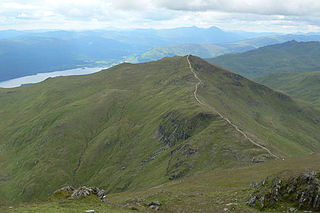
Stob Coire Sgreamhach is a mountain in Lorn, south of Glen Coe in the Scottish Highlands. Its height is 1,072 metres (3,517 ft). It is part of the Bidean nam Bian massif and is often considered a subsidiary peak of Bidean, though since the 1997 revision of Munros Tables it has been classified as a separate Munro. To the northeast is the ridge of Beinn Fhada.

Beinn Ìme is the highest mountain in the Arrochar Alps of Argyll, in the Southern Highlands of Scotland. It reaches 1,011 metres (3,317 ft), making it a Munro.

Meall a' Bhùiridh (IPA:[ˈmauɫ̪ˈaˈvuːɾʲɪʝ]) is a mountain on the edge of Rannoch Moor in the Highlands of Scotland. It lies near the top of Glen Coe and Glen Etive, overlooking the Kings House Hotel inn and the A82 road. The Glencoe Ski area is located on the northern slopes of the peak.
Beinn Ghlas is a mountain in the Breadalbane region of the Scottish Highlands. It lies on the north shore of Loch Tay and is part of the Ben Lawers Range. It is a Munro with a height of 1,103 metres (3,619 ft).

Beinn Fhada or Ben Attow is a mountain in the Scottish Highlands.

The Cairnwell is a mountain in the Eastern Highlands of Scotland, south of Braemar. It is often considered to be one of the most spoiled of the Munros, due to the Glenshee Ski Centre which covers the eastern slope of the mountain.

Beinn a' Chreachain is a Scottish mountain, with a conical top, to the north-west of Loch Lyon.
Stob Coire an Laoigh is a Scottish mountain in The Grey Corries Range, 15 kilometres north east of Kinlochleven.

Mount Blair is a large hill on the Perth and Kinross and Angus border, Scotland, in the southern foothills of the Grampian Mountains.

Sgurr Mhurlagain is a mountain in the Northwest Highlands, Scotland, west of the village of Spean Bridge in Lochaber.
Fraochaidh is a mountain in the Grampian Mountains, located between Glen Coe and Oban on the west coast of Scotland. It lies on the border of Highland and Argyll and Bute.

An Stac is the name of a 814 m mountain in the Northwest Highlands, Scotland, on the shore of Loch Ailort on the west coast of Lochaber. A steep-sided conical peak, the mountain is usually climbed in conjunction with its higher neighbour Rois-bheinn. The nearest settlement is the hamlet of Lochailort.
Meall nan Eun is a mountain in the Grampian Mountains of Scotland. It is located east of Glen Etive in Argyll and Bute.

Beinn Each is a mountain in the southern Grampian Mountains of Scotland. It is located in Stirlingshire, north of the town of Callander.

Beinn na h-Uamha is a mountain in the Northwest Highlands of Scotland. It lies in the Ardgour area of Lochaber, west of the village of Corran.

Binnein Shuas is a mountain in the Grampian Mountains of Scotland. It lies between Loch Laggan and Lochan na h-Earba in Inverness-shire.

Creag Ghuanach is a mountain in the Grampian Mountains of Scotland. It is located in Lochaber, at the southern head of Loch Treig.
Ben Gulabin is a mountain in the Mounth area of the Grampian Mountains in Scotland. It is located on the eastern side of the main A93 road between Blairgowrie and Braemar in upper Glen Shee.

Glas Bheinn (792 m) is a mountain in the Grampian Mountains of Scotland, northeast of the village of Kinlochleven in Lochaber.

Carn Dearg Mor is a mountain in the Grampian Mountains of Scotland. It lies in the Badenoch and Strathspey area of Inverness-shire, east of the town of Kingussie.
