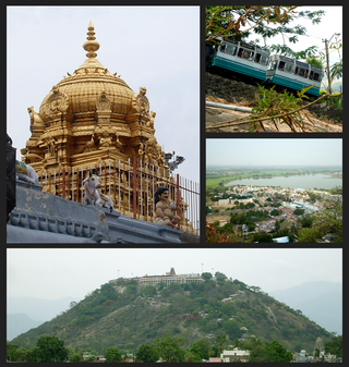
Palani (Tamil:[paɻani], is a town and a taluk headquarters in Dindigul district of the western part of Tamil Nadu state in India. It is located about 106 kilometres south-east of Coimbatore and 122 kilometres north-west of Madurai, 67 kilometres from Kodaikanal. The Palani Murugan Temple or Arulmigu Dhandayuthapani Swamy Temple, dedicated to Murugan is situated on a hill overlooking the town. The temple is visited by more than 7 million pilgrims each year. As of 2011, the town had a population of 292301 which makes it the second largest town in the district after Dindigul.

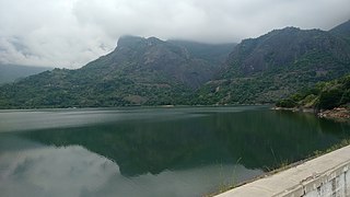
The Anamala or Anaimalai, also known as the Elephant Mountains, are a range of mountains in the southern Western Ghats of central Kerala and span the border of western Tamil Nadu in Southern India. The name anamala is derived from the Malayalam word aana and the Tamil word yaanai, meaning elephant, or from tribal languages. Mala or Malai means 'mountain', and thus literally translatable as 'Elephant mountain'.

Rayavaram is a village Panchayat in Pudukkottai district in Tamil Nadu, India.

Coimbatore district is one of the 38 districts in the state of Tamil Nadu in India. Coimbatore is the administrative headquarters of the district. It is one of the most industrialized districts and a major textile, industrial, commercial, educational, information technology, healthcare and manufacturing hub of Tamil Nadu. The region is bounded by Tiruppur district in the east, Nilgiris district in the north, Erode district in the northeast, Palakkad district, Idukki district and small parts of Thrissur district and Ernakulam district of neighboring state of Kerala in the west and south respectively. As of 2011, Coimbatore district had a population of 3,458,045 with a sex ratio of 1,000 and literacy rate of 84%.
Pollachi is a town and a taluk headquarters in Tamil Nadu state, India. Located about 40 km (25 mi) to the south of Coimbatore, it is the second largest town in the district after Coimbatore. Pollachi is a popular marketplace for jaggery, vegetables and cattle. As of 2011, the town had a population of 90,180. Another name for Pollachi is "Mother of Nature".
Avalpoondurai is a panchayat town in Erode district in the state of Tamil Nadu, India. It is situated 14 kilometres from Erode and an important junction on SH-83A en route to Dharapuram and other important small towns like Modakuruchi and Elumathur. It is about 415 km from Chennai, 100 km from Palani, 100 km from Coimbatore, 50 km from Tiruppur and from Gobicheittipalayam.

Dharapuram is a town situated along the banks of Amaravati River in Tiruppur district in the Indian state of Tamil Nadu. Dharapuram is one of the oldest towns in South India and was the capital of Kongu Nadu under the Cheras, Western Ganga Dynasty and later Kongu Cholas, at which time it was known as Viradapuram. Amaravathi River flows through the town. As of 2011, the town had a population of 67,007. The city houses famous temples including Agatheeswarar Temple, Kaadu Hanumanthasamy temple and many others.

Oddanchatram is a town in Dindigul district in the Indian state of Tamil Nadu. Oddanchatram is a region in the southwest of Tamil Nadu. The Town was carved out of Madurai District in 1985. Oddanchatram is also famous for vegetable and cattle market. As of 2011, the town had a population of 30,064. It is known as vegetable city of Tamil Nadu. Oddanchatram vegetable market is the largest supplying of vegetables in Tamilnadu and Kerala. Agriculture is the major economic support for the town.
Karumathampatti is a Municipality in the Coimbatore district in the state of Tamil Nadu, India. It is one of the prominent developing suburb in Coimbatore metropolitan area, about 25 km away from the city centre. It is situated in between NH544 which connects the city of Coimbatore with Salem – Erode – Tirupur and also in between the State Highway 165 connects Annur – Kamanaikenpalayam. Nearby places are Somanur-3 km, Avinashi-10 km, Tirupur-20 km, Sulur-15 km, Annur-16 km. Coimbatore -27,Mettupalayam-38,Palladam-19. Karumathampatti lies near the junction of two major roads, NH544(Coimbatore – Salem) and Karumathampatti – Annur road.
Kaveripakkam is a town panchayat in Ranipet district in the Indian state of Tamil Nadu.
Kunnathur is a panchayat town in Tirupur district in the Indian state of Tamil Nadu. It was previously under the jurisdiction of the Erode district. However kunnathur is in tiruppur district, legislative assembly consistency for kunnathur is Perundurai which is in Erode district.
Madathukulam is Border to Dindigul District in Tirupur district in the Indian state of Tamil Nadu.
Mettupalayam is a municipality town and taluk headquarters of Mettupalayam Taluk in the Coimbatore district of the Indian state of Tamil Nadu, a suburb of Coimbatore. It is the third largest town in the Coimbatore district after Coimbatore and Pollachi. It's located to the North of the Coimbatore city on the way to Ooty in the foothills of Nilgiri hills. As of 2011, the town had a population of 66,595. Mettupalayam railway station is the starting point of Nilgiri Mountain Railway and it operates the only rack railway in India connecting Ooty and Mettupalayam.
Odayakulam is a panchayat town in Coimbatore district in the Indian state of Tamil Nadu.
Periya Negamam is a panchayat town in Coimbatore district in the southern Indian State of Tamil Nadu. It comes under Pollachi Taluk and pollachi Assembly constituency. Negamam used to be a popular small town serving the commercial and transport needs of many small villages around it until 1980s. With the arrival of frequent city buses to Pollachi and Udumalpet as transportation mode, growth of Negamam remained stunted. Weekly market on Tuesday used to be a big crowd puller.
Pudupalayam is a panchayat town in Chengam taluk of Tiruvanamalai district in the Indian state of Tamil Nadu. Its pincode number is 606 705.It is well connected with Tiruvannamalai and Bangalore. This is at Bangalore Road at 33 km away from the famous Annamalaiyar Temple located in Thiruvannamalai.
Kottur-Malayandipattinam or Kottur is the biggest panchayat town in Anaimalai_taluk of Coimbatore rural district in the Indian state of Tamil Nadu. Its short name is KM Pattinam. The name Kottur-Malayandipattinam is used to distinguish it from other places of the same name in south India, with Malayandipattinam (malai-yandi-pattanam) being the name of the southern part of the town and named after being surrounded by western ghats. It is famous for buying elephant ivory 100 years before, kottur Tamil meaning of kottu is elephant ivory and it also means the end of town.
Unjalur is a panchayat town situated in Erode district in the Indian state of Tamil Nadu. Unjalur is located about 32 kilometres (20 mi) from district headquarters Erode and 8 kilometres (5.0 mi) from Kodumudi, which is known for the Mahudeswarar, Veera Narayana Perumal and Brama Deva temple.
Mondipalayam is a village located in Bhavani taluk, Erode district, Tamil Nadu, India. The village falls under the Mylambadi panchayat. Mondipalayam of Tiruppur district is different from this.
Thirumalaigoundenvalasu is a village and a panchayat in the oddanchatram Taluk of Dindigul district in the South Indian state of Tamil Nadu.

