Andahuaylas District

Last updated
Andahuaylas
Anta Waylla
Antahuaylla, vista panoramica..jpg
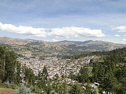
Panoramic view of the Andahuaylas district
Andahuaylas District
Country Flag of Peru.svg  Peru
Region Apurímac
Province Andahuaylas
Capital Andahuaylas
Government
   Mayor Victor Manuel Molina Quintana
Area
  Total
370.03 km2 (142.87 sq mi)
Elevation
2,926 m (9,600 ft)
Population
  Total
34,087
  Density92/km2 (240/sq mi)
Time zone UTC-5 (PET)
UBIGEO 030201
Website muniandahuaylas.gob.pe

Andahuaylas District is one of the nineteen districts of the Andahuaylas Province in Peru. [1]

Contents

Geography

One of the highest peaks of the district is Saqra Urqu at approximately 4,400 m (14,400 ft). Other mountains are listed below: [2]

Ethnic groups

The people in the district are mainly indigenous citizens of Quechua descent. Quechua is the language which the majority of the population (52.01%) learnt to speak in childhood, 47.49% of the residents started speaking using the Spanish language (2007 Peru Census). [3]

See also

References

  1. (in Spanish) Instituto Nacional de Estadística e Informática. Banco de Información Digital Archived April 23, 2008, at the Wayback Machine . Retrieved April 4, 2008.
  2. escale.minedu.gob.pe/ UGEL map Andahuaylas Province (Apurímac Region)
  3. inei.gob.pe Archived January 27, 2013, at the Wayback Machine INEI, Peru, Censos Nacionales 2007, Frequencias: Preguntas de Población

13°39′27″S73°23′00″W / 13.65750°S 73.38333°W / -13.65750; -73.38333