Tamburco District

Last updated
Tamburco
Tampurqu
Uspaccocha entrada.JPG
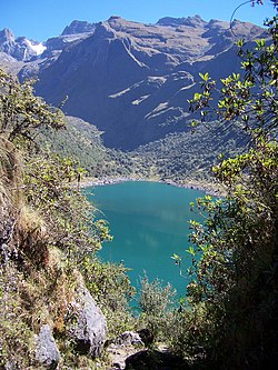
Ampay (in the background on the left) as seen from Usphaqucha
Tamburco District
Country Flag of Peru.svg  Peru
Region Apurímac
Province Abancay
FoundedDecember 31, 1941
Capital Tamburco
Government
   Mayor Fernando Zuñiga Gutierrez
Area
  Total
54.6 km2 (21.1 sq mi)
Elevation
2,581 m (8,468 ft)
Population
  Total
7,216
  Density130/km2 (340/sq mi)
Time zone UTC-5 (PET)
UBIGEO 030109

Tamburco District is one of the nine districts of the province Abancay in Peru. [1]

Contents

Climate

Climate data for Granja San Antonio, Tamburco, elevation 2,772 m (9,094 ft), (1991–2020)
MonthJanFebMarAprMayJunJulAugSepOctNovDecYear
Mean daily maximum °C (°F)20.9
(69.6)
20.2
(68.4)
20.3
(68.5)
20.4
(68.7)
20.9
(69.6)
20.3
(68.5)
20.3
(68.5)
21.1
(70.0)
22.2
(72.0)
22.6
(72.7)
23.3
(73.9)
21.7
(71.1)
21.2
(70.1)
Mean daily minimum °C (°F)8.9
(48.0)
8.8
(47.8)
8.8
(47.8)
8.3
(46.9)
7.3
(45.1)
6.6
(43.9)
6.0
(42.8)
6.8
(44.2)
8.3
(46.9)
8.7
(47.7)
9.1
(48.4)
9.0
(48.2)
8.0
(46.5)
Average precipitation mm (inches)198.5
(7.81)
256.5
(10.10)
97.4
(3.83)
50.1
(1.97)
15.2
(0.60)
8.6
(0.34)
8.6
(0.34)
23.0
(0.91)
15.4
(0.61)
58.2
(2.29)
64.4
(2.54)
129.2
(5.09)
925.1
(36.43)
Source: National Meteorology and Hydrology Service of Peru [2]

See also

References

  1. (in Spanish) Instituto Nacional de Estadística e Informática. Banco de Información Digital Archived 2008-04-23 at the Wayback Machine . Retrieved April 4, 2008.
  2. "Normales Climaticás Estándares y Medias 1991-2020". National Meteorology and Hydrology Service of Peru. Archived from the original on 21 August 2023. Retrieved 6 November 2023.

13°37′01″S72°52′16″W / 13.61694°S 72.87111°W / -13.61694; -72.87111