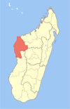
Andramy is a town and commune (Malagasy: kaominina) in western Madagascar. It belongs to the district of Morafenobe, which is a part of Melaky Region. The population of the commune was estimated to be approximately 12,000 in 2001 commune census.[1]
Malagasy is an Austronesian language and the national language of Madagascar. Most people in Madagascar speak it as a first language as do some people of Malagasy descent elsewhere.
Madagascar, officially the Republic of Madagascar, and previously known as the Malagasy Republic, is an island country in the Indian Ocean, approximately 400 kilometres off the coast of East Africa. The nation comprises the island of Madagascar and numerous smaller peripheral islands. Following the prehistoric breakup of the supercontinent Gondwana, Madagascar split from the Indian subcontinent around 88 million years ago, allowing native plants and animals to evolve in relative isolation. Consequently, Madagascar is a biodiversity hotspot; over 90% of its wildlife is found nowhere else on Earth. The island's diverse ecosystems and unique wildlife are threatened by the encroachment of the rapidly growing human population and other environmental threats.
Districts are second-level administrative divisions of Madagascar below the regions. There are 114 districts in Madagascar. Districts are in their turn divided into communes; while some of the districts in urban areas and offshore islands each consist of only one commune, most of the districts are divided typically into 5–20 communes.
Only primary schooling is available. The majority 69% of the population of the commune are farmers, while an additional 39% receives their livelihood from raising livestock. The most important crop is rice, while other important products are sugarcane, maize and cassava. Services provide employment for 1% of the population.[1]
Rice is the seed of the grass species Oryza sativa or Oryza glaberrima. As a cereal grain, it is the most widely consumed staple food for a large part of the world's human population, especially in Asia. It is the agricultural commodity with the third-highest worldwide production, after sugarcane and maize.
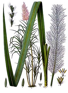
Sugarcane, or sugar cane, are several species of tall perennial true grasses of the genus Saccharum, tribe Andropogoneae, native to the warm temperate to tropical regions of South, Southeast Asia, and New Guinea, and used for sugar production. It has stout, jointed, fibrous stalks that are rich in the sugar sucrose, which accumulates in the stalk internodes. The plant is two to six metres tall. All sugar cane species can interbreed and the major commercial cultivars are complex hybrids. Sugarcane belongs to the grass family Poaceae, an economically important seed plant family that includes maize, wheat, rice, and sorghum, and many forage crops.
Maize, also known as corn, is a cereal grain first domesticated by indigenous peoples in southern Mexico about 10,000 years ago. The leafy stalk of the plant produces pollen inflorescences and separate ovuliferous inflorescences called ears that yield kernels or seeds, which are fruits.
A geographic coordinate system is a coordinate system that enables every location on Earth to be specified by a set of numbers, letters or symbols. The coordinates are often chosen such that one of the numbers represents a vertical position and two or three of the numbers represent a horizontal position; alternatively, a geographic position may be expressed in a combined three-dimensional Cartesian vector. A common choice of coordinates is latitude, longitude and elevation. To specify a location on a plane requires a map projection.
This page is based on this Wikipedia article Text is available under the CC BY-SA 4.0 license; additional terms may apply. Images, videos and audio are available under their respective licenses.
Related Research Articles
Ambolodia Sud or Ambolodia Atsimo is a town and commune in western Madagascar. It belongs to the district of Besalampy, which is a part of Melaky Region. The population of the commune was estimated to be approximately 2,000 in 2001 commune census.
Antsahidoha Bebao or Antsaidoha-Bebao is a town and commune in western Madagascar. It belongs to the district of Maintirano, which is a part of Melaky Region. The population of the commune was estimated to be approximately 9,000 in 2001 commune census.
Berevo-Ranobe or Berevo-sur-Ranobe is a town and commune in western Madagascar. It belongs to the district of Maintirano, which is a part of Melaky Region. The population of the commune was estimated to be approximately 8,000 in 2001 commune census.
Andranovao is a town and commune in western Madagascar. It belongs to the district of Maintirano, which is a part of Melaky Region. The population of the commune was estimated to be approximately 12,000 in 2001 commune census.
Bebakony Sud is a town and commune in western Madagascar. It belongs to the district of Maintirano, which is a part of Melaky Region. The population of the commune was estimated to be approximately 7,000 in 2001 commune census.
Marohazo is a town and commune in western Madagascar. It belongs to the district of Maintirano, which is a part of Melaky Region. The population of the commune was estimated to be approximately 5,000 in 2001 commune census.
Maromavo is a town and commune in western Madagascar. It belongs to the district of Maintirano, which is a part of Melaky Region. The population of the commune was estimated to be approximately 3,000 in 2001 commune census.
Veromanga is a town and commune in western Madagascar. It belongs to the district of Maintirano, which is a part of Melaky Region. The population of the commune was estimated to be approximately 9,000 in 2001 commune census.
Imerimandroso is a town and commune in Madagascar. It belongs to the district of Ambatondrazaka, which is a part of Alaotra-Mangoro Region. The population of the commune was estimated to be approximately 11,000 in 2001 commune census.
Ankilivalo is a town and commune in Madagascar. It belongs to the district of Mahabo, which is a part of Menabe Region. The population of the commune was estimated to be approximately 13,000 in 2001 commune census.
Bemanonga is a town and commune in Madagascar. It belongs to the district of Morondava, which is a part of Menabe Region. The population of the commune was estimated to be approximately 22,000 in 2001 commune census.
Manja is a town and commune in Madagascar. It belongs to the district of Manja, which is a part of Menabe Region. The population of the commune was estimated to be approximately 9,000 in 2001 commune census.
Beahitse is a town and commune in southwestern Madagascar. It belongs to the district of Ampanihy, which is a part of Atsimo-Andrefana Region. The population of the commune was estimated to be approximately 17,000 in 2001 commune census.
Belafike is a town and commune in southwestern Madagascar. It belongs to the district of Ampanihy, which is a part of Atsimo-Andrefana Region. The population of the commune was estimated to be approximately 10,000 in 2001 commune census.
Lazarivo is a town and commune in southwest Madagascar. It belongs to the district of Betioky Sud, which is a part of Atsimo-Andrefana Region. The population of the commune was estimated to be approximately 17,000 in 2001 commune census.
Antanimena is a town and commune in Madagascar. It belongs to the district of Toliara II, which is a part of Atsimo-Andrefana Region. The population of the commune was estimated to be approximately 4,000 in 2001 commune census.
Amboavory is a town and commune in Madagascar. It belongs to the district of Amparafaravola, which is a part of Alaotra-Mangoro Region. It is situated on the northern banks of Lake Alaotra. The population of the commune was estimated to be approximately 23,000 in 2001 commune census.
Mahaboboka is a town and commune in Madagascar. It belongs to the district of Sakaraha, which is a part of Atsimo-Andrefana Region. The population of the commune was estimated to be approximately 3,000 in 2001 commune census.
Ambatolahy is a town and commune in Madagascar. It belongs to the district of Antanifotsy, which is a part of Vakinankaratra Region. The population of the commune was estimated to be approximately 9,000 in 2001 commune census.
Anosivelo is a town and commune in Madagascar. It belongs to the district of Farafangana, which is a part of Atsimo-Atsinanana Region. The population of the commune was estimated to be approximately 17,000 in 2001 commune census.