Mahajanga was a former province of Madagascar that had an area of 150,023 km². It had a population of 1,896,000 (2004). Its capital was Mahajanga, the second largest city in Madagascar.

Maintirano is a coastal city, commune urbaine, and Catholic bishopric in western Madagascar approximately 325 kilometres west of the capital Antananarivo. It belongs to the district of Maintirano, which is a part of Melaky Region – and is capital of both.

Antsalova is a town and commune in western Madagascar. It belongs to the district of Antsalova, which is a part of Melaky Region. The population of the commune was estimated to be approximately 58,280 in 2018.
Anjialava is a rural municipality in northern Madagascar. It belongs to the district of Sambava, which is a part of Sava Region. The population of the commune was estimated to be approximately 9,000 in 2001 commune census.
Melaky is a region in northwestern Madagascar. It borders Boeny Region in northeast, Betsiboka in east, Bongolava in southeast and Menabe in south. The capital of the region is Maintirano. The population was estimated to be 309,805 in 2018 within the area of 38,852 km2 (15,001 sq mi). Melaky has the smallest population and the smallest population density of all Malagasy regions.
Ambolodia Sud or Ambolodia Atsimo is a town and commune in western Madagascar. It belongs to the district of Besalampy, which is a part of Melaky Region. The population of the commune was estimated to be approximately 2,000 in 2001 commune census.
Bekodoka is a town and commune in western Madagascar. It belongs to the district of Besalampy, which is a part of Melaky Region. The population of the commune was estimated to be approximately 10,000 in 2001 commune census.
Mahabe is a town and commune in western Madagascar. It belongs to the district of Besalampy, which is a part of Melaky Region. The population of the commune was estimated to be approximately 10,000 in 2001 commune census.
Soanenga is a town and commune in western Madagascar. It belongs to the district of Besalampy, which is a part of Melaky Region. The population of the commune was estimated to be approximately 9,000 in 2001 commune census.
Ankisatra is a town and commune in western Madagascar. It belongs to the district of Maintirano, which is a part of Melaky Region. The population of the commune was estimated to be approximately 3,000 in 2001 commune census.
Betanatanana is a rural municipality in western Madagascar. It belongs to the district of Maintirano, which is a part of Melaky Region. The population of the commune was estimated to be approximately 7,000 in 2001 commune census.
Maromavo is a town and commune in western Madagascar. It belongs to the district of Maintirano, which is a part of Melaky Region. The population of the commune was estimated to be approximately 3,000 in 2001 commune census.
Trangahy is a rural municipality in western Madagascar. It belongs to the district of Antsalova, which is a part of Melaky Region. The population of the commune was estimated to be approximately 8,000 in 2001 commune census.

Bekopaka is a rural municipality in western Madagascar. It belongs to the district of Antsalova, which is a part of Melaky Region. The population of the commune was estimated to be approximately 9,000 in 2001 commune census.
Masoarivo is a rural municipality in western Madagascar. It belongs to the district of Antsalova, which is a part of the region of Melaky. The population of the commune was estimated to be approximately 8,000 in 2001 commune census.
Andramy is a rural municipality in western Madagascar. It belongs to the district of Morafenobe, which is a part of Melaky Region. The population of the commune was estimated to be approximately 12,000 in 2001 commune census.
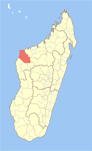
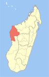
Besalampy is a district in western Madagascar. It is a part of Melaky Region and borders the districts of Soalala in northeast, Kandreho in east, Ambatomainty in southeast, Morafenobe in south and Maintirano in southwest. The area is 11,753 km2 (4,538 sq mi) and the population was estimated to be 37,782 in 2001.
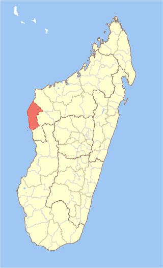
Maintirano is a district in western Madagascar. It is a part of Melaky Region and borders the districts of Besalampy in north, Morafenobe in east and Antsalova in south. The area is 10,031 km2 (3,873 sq mi) and the population was estimated to be 52,700 in 2001.
Ankilizato is a town and commune in southwestern Madagascar. It belongs to the district of Ampanihy, which is a part of Atsimo-Andrefana Region. The population of the commune was estimated to be approximately 7,000 in 2001 commune census.
Bemarivo Reserve is a wildlife reserve in the north-west of Madagascar. It was created in 1956 and covers an area of 12,080 hectares. The reserve is known for its fauna especially endemic birds.