Bekodoka

Last updated
Bekodoka
Madagascar location map.svg
Red pog.svg
Bekodoka
Location in Madagascar
Coordinates: 16°58′S45°6′E / 16.967°S 45.100°E / -16.967; 45.100
CountryFlag of Madagascar.svg  Madagascar
Region Melaky
District Besalampy
Elevation [1] 262 m (860 ft)
Population (2001) [2]
  Total 10,000
Time zone EAT (UTC3)

Bekodoka is a town and commune (Malagasy : kaominina) in western Madagascar. It belongs to the district of Besalampy, which is a part of Melaky Region. The population of the commune was estimated to be approximately 10,000 in 2001 commune census. [2]

Malagasy is an Austronesian language and the national language of Madagascar. Most people in Madagascar speak it as a first language as do some people of Malagasy descent elsewhere.

Madagascar island nation off the coast of Southeast Africa, in the Indian Ocean

Madagascar, officially the Republic of Madagascar, and previously known as the Malagasy Republic, is an island country in the Indian Ocean, approximately 400 kilometres off the coast of East Africa. The nation comprises the island of Madagascar and numerous smaller peripheral islands. Following the prehistoric breakup of the supercontinent Gondwana, Madagascar split from the Indian subcontinent around 88 million years ago, allowing native plants and animals to evolve in relative isolation. Consequently, Madagascar is a biodiversity hotspot; over 90% of its wildlife is found nowhere else on Earth. The island's diverse ecosystems and unique wildlife are threatened by the encroachment of the rapidly growing human population and other environmental threats.

Districts of Madagascar

Districts are second-level administrative divisions of Madagascar below the regions. There are 114 districts in Madagascar. Districts are in their turn divided into communes; while some of the districts in urban areas and offshore islands each consist of only one commune, most of the districts are divided typically into 5–20 communes.

Only primary schooling is available. The majority 90% of the population of the commune are farmers, while an additional 9% receives their livelihood from raising livestock. The most important crops are rice and raffia palm; also cassava is an important agricultural product. Services provide employment for 1% of the population. [2]

Rice cereal grain and seed of Oryza sativa

Rice is the seed of the grass species Oryza sativa or Oryza glaberrima. As a cereal grain, it is the most widely consumed staple food for a large part of the world's human population, especially in Asia. It is the agricultural commodity with the third-highest worldwide production, after sugarcane and maize.

Raffia palm genus of plants

Raffia palms (Raphia) are a genus of about twenty species of palms native to tropical regions of Africa, and especially Madagascar, with one species also occurring in Central and South America. R. taedigera is the source of raffia fibers, which are the veins of the leaves, and this species produces a fruit called "brazilia pods", "uxi nuts" or "uxi pods".

Cassava Species of plant

Manihot esculenta, commonly called cassava, manioc, yuca, macaxeira, mandioca, aipim and Brazilian arrowroot, is a woody shrub native to South America of the spurge family, Euphorbiaceae. It is extensively cultivated as an annual crop in tropical and subtropical regions for its edible starchy tuberous root, a major source of carbohydrates. Though it is often called yuca in Spanish and in the United States, it is not related to yucca, a shrub in the family Asparagaceae. Cassava, when dried to a powdery extract, is called tapioca; its fried, granular form is named garri.

References and notes

  1. Estimated based on DEM data from Shuttle Radar Topography Mission
  2. 1 2 3 "ILO census data". Cornell University. 2002. Retrieved 2008-03-03.

Coordinates: 16°58′S45°6′E / 16.967°S 45.100°E / -16.967; 45.100

Geographic coordinate system Coordinate system

A geographic coordinate system is a coordinate system that enables every location on Earth to be specified by a set of numbers, letters or symbols. The coordinates are often chosen such that one of the numbers represents a vertical position and two or three of the numbers represent a horizontal position; alternatively, a geographic position may be expressed in a combined three-dimensional Cartesian vector. A common choice of coordinates is latitude, longitude and elevation. To specify a location on a plane requires a map projection.


Related Research Articles

Soalala Place in Boeny, Madagascar

Soalala is a town and commune in western Madagascar. It belongs to the district of Soalala, which is a part of Boeny Region. The population of the commune was estimated to be approximately 15,000 in 2001 commune census.

Antsirabe Nord Place in Sava, Madagascar

Antsirabe Nord or Antsirabe Avaratra is a town and commune in northern Madagascar. It belongs to the district of Vohemar, which is a part of Sava Region. The population of the commune was estimated to be approximately 25,000 in 2001 commune census.
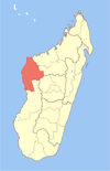
Matsondana Place in Sofia, Madagascar

Matsondana is a town and commune in Madagascar. It belongs to the district of Befandriana-Nord, which is a part of Sofia Region. The population of the commune was estimated to be approximately 40,000 in 2001 commune census.

Antanambao Andranolava Place in Boeny, Madagascar

Antanambao Andranolava is a town and commune in Madagascar. It belongs to the district of Marovoay, which is a part of Boeny Region. The population of the commune was estimated to be approximately 5,000 in 2001 commune census.

Anjiajia Place in Boeny, Madagascar

Anjiajia is a town and commune in Madagascar. It belongs to the district of Ambato-Boeni, which is a part of Boeny Region. The population of the commune was estimated to be approximately 13,000 in 2001 commune census.

Ambohipaky Place in Boeny, Madagascar

Ambohipaky is a town and commune in Madagascar. It belongs to the district of Soalala, which is a part of Boeny Region. The population of the commune was estimated to be approximately 7,000 in 2001 commune census.

Ambolodia Sud Place in Melaky, Madagascar

Ambolodia Sud or Ambolodia Atsimo is a town and commune in western Madagascar. It belongs to the district of Besalampy, which is a part of Melaky Region. The population of the commune was estimated to be approximately 2,000 in 2001 commune census.

Berevo Place in Menabe, Madagascar

Berevo is a town and commune in Madagascar. It belongs to the district of Belo sur Tsiribihina, which is a part of Menabe Region. The population of the commune was estimated to be approximately 3,000 in 2001 commune census.

Ankilimivory Place in Atsimo-Andrefana, Madagascar

Ankilimivory is a town and commune in southwestern Madagascar. It belongs to the district of Ampanihy, which is a part of Atsimo-Andrefana Region. The population of the commune was estimated to be approximately 15,000 in 2001 commune census.

Mandrofify Place in Atsimo-Andrefana, Madagascar

Mandrofify or Manorofify is a town and commune in Madagascar. It belongs to the district of Toliara II, which is a part of Atsimo-Andrefana Region. The town is situated at the Onilahy River. The population of the commune was estimated to be approximately 8,000 in 2001 commune census.

Ampasipotsy Gare Place in Alaotra-Mangoro, Madagascar

Ampasipotsy Gare is a town and commune in Madagascar. It belongs to the district of Moramanga, which is a part of Alaotra-Mangoro Region. The population of the commune was estimated to be approximately 7,000 in 2001 commune census.

Beforona Place in Alaotra-Mangoro, Madagascar

Beforona is a town and commune in Madagascar. It belongs to the district of Moramanga, which is a part of Alaotra-Mangoro Region. The population of the commune was estimated to be approximately 13,000 in 2001 commune census.

Sabotsy Anjiro Place in Alaotra-Mangoro, Madagascar

Sabotsy Anjiro is a town and commune in Madagascar. It belongs to the district of Moramanga, which is a part of Alaotra-Mangoro Region. The population of the commune was estimated to be approximately 15,000 in 2001 commune census.

Anjoma Ramartina Place in Vakinankaratra, Madagascar

Anjoma Ramartina is a town and commune in Madagascar. It belongs to the district of Betafo, which is a part of Vakinankaratra Region. The population of the commune was estimated to be approximately 15,000 in 2001 commune census.

Analavory, Miarinarivo Place in Itasy, Madagascar

Analavory is a town and commune in Madagascar. It belongs to the district of Miarinarivo, which is a part of Itasy Region. The population of the commune was estimated to be approximately 45,000 in 2001 commune census.

Sahatona Place in Haute Matsiatra, Madagascar

Sahatona is a town and commune in Madagascar. It belongs to the district of Ambohimahasoa, which is a part of Haute Matsiatra Region. The population of the commune was estimated to be approximately 10,000 in 2001 commune census.

Tataho Place in Vatovavy-Fitovinany, Madagascar

Tataho is a town and commune in Madagascar. It belongs to the district of Manakara, which is a part of Vatovavy-Fitovinany Region. The population of the commune was estimated to be approximately 4,000 in 2001 commune census.

Mahaela Place in Vatovavy-Fitovinany, Madagascar

Mahaela is a town and commune in Madagascar. It belongs to the district of Mananjary, which is a part of Vatovavy-Fitovinany Region. The population of the commune was estimated to be approximately 23,000 in 2001 commune census.

Alarobia Place in Analamanga, Madagascar

Alarobia is a town and commune in Madagascar. It belongs to the district of Manjakandriana, which is a part of Analamanga Region. The population of the commune was estimated to be approximately 16,000 in 2001 commune census.

Ambatomanga, Manjakandriana Place in Analamanga, Madagascar

Ambatomanga is a town and commune in Madagascar. It belongs to the district of Manjakandriana, which is a part of Analamanga Region. The population of the commune was estimated to be approximately 6,000 in 2001 commune census.