Armenia is a landlocked country situated in the Transcaucasus region, South Caucasus, bordered on the north and east by Georgia and Azerbaijan and on the south and west by Iran, Azerbaijan's exclave Nakhchivan, and Turkey. Geopolitically, Armenia can be considered as part of Europe.
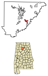
Hanceville is a city in Cullman County, Alabama, United States. At the 2020 census, the population was 3,217.

Criuleni is a city in Moldova, seat of the Criuleni District. The city administers two villages, Ohrincea and Zolonceni.

Düzce is the capital city of Düzce Province is the eighty-first Province in Turkey. The population is 367,087 and in 2009 was 125,240, an increase from 61,878 in 1990.

Charlotte is the largest parish of Saint Vincent and the Grenadines, situated on the eastern coast of the island of Saint Vincent. With an area of 149 km², its size is comparable to that of the British Virgin Islands.) The parish has the longest coastline of all the parishes and is also larger than the three smallest parishes combined. The parish possesses a very rough and rugged topography with very little flat land occurring towards the coast. as a result of these features, parts of the north of the parish cannot be accessed by a main road. Up until the building of a bridge over the Rabacca Dry River access to the north side of the river was not possible when rain caused the river to swell and make the path impassable.

Çınar is a district of Diyarbakır Province of Turkey. Its population is 74,207 according to Turkish government statistics as of 2018.

uMzinyathi is one of the 11 district municipalities ("districts") of KwaZulu-Natal province in South Africa. The seat of uMzinyathi is Dundee. The majority of its 456 452 people speak IsiZulu. The district code is DC24
Jama is one of the woredas in the Amhara Region of Ethiopia. Part of the Debub Wollo Zone, Jama is bordered on the southeast by the Qechene River which separates it from the Semien Shewa Zone, on the west by Kelala, on the north by Legahida, and on the northeast by Were Ilu. Towns in Jama include Dagolo, Faj, and Shul Afaf.
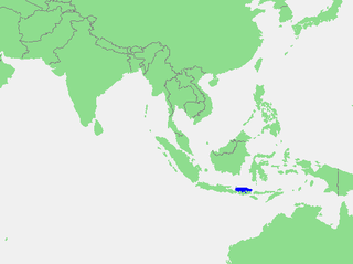
The Bali Sea is the body of water north of the island of Bali and south of Kangean Island in Indonesia. The sea forms the south-west part of the Flores Sea, and the Madura Strait opens into it from the west.

Rebolledo de la Torre is a municipality and town located in the province of Burgos, Castile and León, Spain. According to the 2004 census (INE), the municipality has a population of 167 inhabitants.
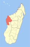
Beravina is a town and commune in western Madagascar. It belongs to the district of Morafenobe, which is a part of Melaky Region. The population of the commune was estimated to be approximately 3,000 in 2001 commune census.
Tansablogo is a village in the Salogo Department of Ganzourgou Province in central Burkina Faso. The village has a population of 800.

The Cabarita River, originally the Cabaritta, is a river in Jamaica. The Mayfield River is a tributary.
The Camelot River is a river of Fiordland National Park, New Zealand. It is formed from the confluence of the Elaine Stream and Cozette Burn and flows west into the Gaer Arm of Kaikiekie / Bradshaw Sound. The estuary is protected by the Kutu Parera Marine Reserve.
The Stewiacke Valley is a Canadian rural region in central Nova Scotia running from western Pictou County through southern Colchester County to the Shubenacadie River.

Grão-Pará is a municipality in the state of Santa Catarina in the South region of Brazil.

Kreitzerisen is a glacier, 8 nautical miles (15 km) long, flowing north between the Tertene Nunataks and Bamse Mountain in the Sør Rondane Mountains of Antarctica. It was mapped by Norwegian cartographers in 1957 from air photos taken by U.S. Navy Operation Highjump, 1946–47, and named for Lieutenant William R. Kreitzer, U.S. Navy, plane commander on one of the three Operation Highjump aerial crews which photographed this and other coastal areas between 14°E and 164°E.

Jessore, officially Jashore, is a major city in Jashore District situated in the south-western region of Bangladesh. It is the administrative centre (headquarter) of the eponymous district and the third largest city in Khulna Division. It is one of the industrious and developed cities in Bangladesh and it is the second developed city of Khulna Division. Jessore city consists of 9 wards and 73 mahalls. Jessore municipality was established in 1864. The area of the town is 21.15 km2. It has a population of about 2,98,000 according to the record of Jessore municipality. Jessore also has a domestic airport named as Jessore Airport.
This page is based on this
Wikipedia article Text is available under the
CC BY-SA 4.0 license; additional terms may apply.
Images, videos and audio are available under their respective licenses.